Map of Park County - Park County is a county located in the U.S. state of Colorado. Park County Map showing cities, highways, important places and water bodies. Get Where is Park County located in the map, major cities in Park county, population, areas, and places of interest.
Map of Park County, Colorado
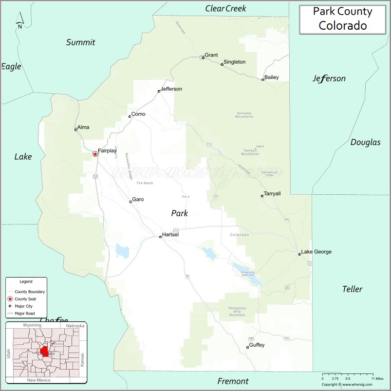
About Park County Map, Colorado: The map showing the county boundary, county seat, major cities, highways, water bodies and neighbouring counties.
Most Viewed Links
Map of Park County, Colorado
Park County is a county located in the U.S. state of Colorado. It's county seat is Fairplay. As per 2020 census, the population of Park County is 17720 people and population density is square miles. According to the United States Census Bureau, the county has a total area of 2,209.36 sq mi (5,722 km2). Park County was established on -13938.
Park County Facts
| Continent | North America |
| Country | United States |
| State | Colorado |
| County Seat | Fairplay |
| Largest City/Town | Fairplay |
| Established | 1861 |
| Total Area | 2,211 sq mi (5,726 sq km) |
| Land Area | 2,194 sq mi (5,682 sq km) |
| Water Area | 17 sq mi (44 sq km) |
| Population | 17,390 (Census 2020) |
| Population Density | 7.9 people per sq mi |
| Time Zone | Mountain Time Zone (MST/MDT) |
| Major Highways | US Highway 285, US Highway 24, State Highway 9 |
| Major Rivers | South Platte River, Tarryall Creek |
| Neighboring Counties | Jefferson County, Clear Creek County, Summit County, Lake County, Chaffee County, Fremont County, Teller County |
| Famous For | South Park basin, mountain recreation, gold mining history, and scenic alpine landscapes |
| Top Attractions | South Park City Museum, Kenosha Pass, Eleven Mile State Park, Mount Lincoln |
| Official Website | Official Website |
About Park County, Colorado
Park County is located in central Colorado in the United States and was established in 1861 as one of the original counties of the Colorado Territory. The county seat and largest town is Fairplay. The county is known for mountain scenery, historic mining towns, high-altitude valleys, fishing streams, and recreation in the South Park basin region.
Cities and Communities in Park County, Colorado
| City/Town | Population (Census 2020) | Latitude & Longitude |
|---|---|---|
| Fairplay (county seat) | 724 | 39.2247°N, 106.0019°W |
| Alma | 296 | 39.2869°N, 106.0628°W |
| Bailey | 9,000 | 39.4069°N, 105.4731°W |
| Como | 434 | 39.3158°N, 105.8928°W |
| Jefferson | Historic community | 39.3600°N, 105.8497°W |
| Hartsel | Historic community | 39.0192°N, 105.7958°W |
| Guffey nearby area | Mountain community | 38.7517°N, 105.5228°W |
| Lake George area | Recreation region | 39.0164°N, 105.4617°W |
Golf Courses in Park County, Colorado
| Golf Course | Location | Latitude & Longitude |
|---|---|---|
| Breckenridge Golf Club | Breckenridge nearby | 39.5142°N, 106.0328°W |
| Mount Massive Golf Course | Leadville nearby | 39.2522°N, 106.3139°W |
| Evergreen Golf Course | Evergreen nearby | 39.6339°N, 105.3178°W |
Roads and Highways in Park County, Colorado
Major highways connect the county to mountain recreation areas and central Colorado communities.
- US Highway 285 - major north-south highway connecting Fairplay with Denver and Buena Vista
- US Highway 24 - route linking South Park with Colorado Springs and Leadville regions
- Colorado State Highway 9 - scenic highway connecting Fairplay with Breckenridge and Cañon City
Neighboring Counties of Park County
- Jefferson County (northeast)
- Clear Creek County (north)
- Summit County (northwest)
- Lake County (west)
- Chaffee County (southwest)
- Fremont County (south)
- Teller County (southeast)
Top Attractions in Park County, Colorado
The county offers a mix of scenic, historical, and outdoor recreation attractions.
- South Park City Museum - restored mining-era museum complex in Fairplay
- Kenosha Pass - scenic mountain pass known for hiking and autumn aspen views
- Eleven Mile State Park - boating, fishing, and camping destination
- Mount Lincoln and Mosquito Range - hiking and alpine recreation area
- South Platte River headwaters - fishing and rafting opportunities
- Como Historic Railroad District - preserved railroad and mining heritage area
- Tarryall Reservoir recreation area - fishing, camping, and wildlife viewing
- Boreas Pass Scenic Road nearby - historic railroad route and mountain scenery
- Pike National Forest recreation areas - hiking, camping, and off-road trails
- Hoosier Pass - scenic mountain crossing between Park and Summit counties
- Buffalo Peaks Wilderness nearby - wilderness hiking and backpacking destination
- Gold panning and historic mining sites - attractions tied to Colorado Gold Rush history
Distance from Park County to Nearby Cities
The following distances are measured by road (driving).
- Fairplay to Breckenridge (Summit County), Colorado - 23 mi (37 km)
- Fairplay to Buena Vista (Chaffee County), Colorado - 39 mi (63 km)
- Fairplay to Denver (Denver County), Colorado - 85 mi (137 km)
- Fairplay to Colorado Springs (El Paso County), Colorado - 88 mi (142 km)
- Fairplay to Leadville (Lake County), Colorado - 61 mi (98 km)
- Fairplay to Aspen (Pitkin County), Colorado - 122 mi (196 km)
- Fairplay to Vail (Eagle County), Colorado - 70 mi (113 km)
- Fairplay to Cañon City (Fremont County), Colorado - 63 mi (101 km)
- Fairplay to Grand Junction (Mesa County), Colorado - 234 mi (377 km)
- Fairplay to Gunnison (Gunnison County), Colorado - 122 mi (196 km)
- Fairplay to Fort Collins (Larimer County), Colorado - 146 mi (235 km)
- Fairplay to Moab (Grand County), Utah - 330 mi (531 km)
FAQs about Park County
Park County is located in central Colorado within the Rocky Mountains and South Park basin region of the United States.
The population of Park County was 17,390 according to the Census 2020.
Park County is known for mountain scenery, gold mining history, outdoor recreation, and the South Park basin.
The county is served by US Highway 285, US Highway 24, and Colorado State Highway 9.
Popular attractions include South Park City Museum, Kenosha Pass, Eleven Mile State Park, and Mount Lincoln.
References
- QuickFacts - U.S. Census Bureau
- United States Census Bureau
- United States Geological Survey (USGS)
- National Geodetic Survey
- Official Website
- Adams County Map
- Alamosa County Map
- Arapahoe County Map
- Archuleta County Map
- Baca County Map
- Bent County Map
- Boulder County Map
- Broomfield County Map
- Chaffee County Map
- Cheyenne County Map
- Clear Creek County Map
- Conejos County Map
- Costilla County Map
- Crowley County Map
- Custer County Map
- Delta County Map
- Denver County Map
- Dolores County Map
- Douglas County Map
- Eagle County Map
- Elbert County Map
- El Paso County Map
- Fremont County Map
- Garfield County Map
- Gilpin County Map
- Grand County Map
- Gunnison County Map
- Hinsdale County Map
- Huerfano County Map
- Jackson County Map
- Jefferson County Map
- Kiowa County Map
- Kit Carson County Map
- Lake County Map
- La Plata County Map
- Larimer County Map
- Las Animas County Map
- Lincoln County Map
- Logan County Map
- Mesa County Map
- Mineral County Map
- Moffat County Map
- Montezuma County Map
- Montrose County Map
- Morgan County Map
- Otero County Map
- Ouray County Map
- Park County Map
- Phillips County Map
- Pitkin County Map
- Prowers County Map
- Pueblo County Map
- Rio Blanco County Map
- Rio Grande County Map
- Routt County Map
- Saguache County Map
- San Juan County Map
- San Miguel County Map
- Sedgwick County Map
- Summit County Map
- Teller County Map
- Washington County Map
- Weld County Map
- Yuma County Map
- Alabama Counties
- Alaska boroughs
- Arizona Counties
- Arkansas Counties
- California County Map
- Colorado Counties
- Connecticut Counties
- Delaware Counties
- Florida County Map
- Georgia County Map
- Hawaii Counties
- Idaho Counties
- Illinois Counties
- Indiana Counties
- Iowa Counties
- Kansas Counties
- Kentucky Counties
- Louisiana Counties
- Maine Counties
- Maryland Counties
- Massachusetts Counties
- Michigan County Map
- Minnesota Counties
- Mississippi Counties
- Missouri Counties
- Montana Counties
- Nebraska Counties
- Nevada Counties
- New York Counties
- New Hampshire Counties
- New Jersey Counties
- New Mexico Counties
- North Carolina Counties
- North Dakota Counties
- Ohio County Map
- Oklahoma Counties
- Oregon Counties
- Pennsylvania Counties
- Rhode Island Counties
- South Carolina Counties
- South Dakota Counties
- Map of Tennessee
- Texas County Map
- Utah Counties
- Vermont Counties
- Virginia Counties
- Washington Counties
- West Virginia Counties
- Wisconsin Counties
- Wyoming Counties