
Map of Adams County - Adams County is a county located in the U.S. state of Colorado. Adams County Map showing cities, highways, important places and water bodies. Get Where is Adams County located in the map, major cities in Adams county, population, areas, and places of interest.
Map of Adams County, Colorado
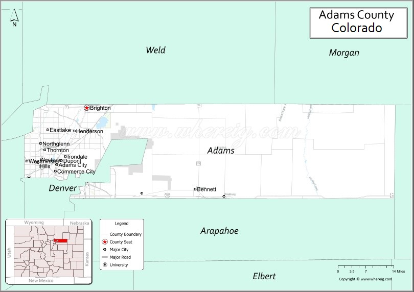
About Adams County Map, Colorado: The map showing the county boundary, county seat, major cities, highways, water bodies and neighbouring counties.
Most Viewed Links
Map of Adams County, Colorado
Adams County is a county located in the U.S. state of Colorado. It's county seat is Brighton. As per 2020 census, the population of Adams County is 522140 people and population density is square miles. According to the United States Census Bureau, the county has a total area of 1,182.29 sq mi (3,062 km2). Adams County was established on 1050.
Adams County Facts
| Continent | North America |
| Country | United States |
| State | Colorado |
| County Seat | Brighton |
| Largest City/Town | Thornton |
| Established | 1901 |
| Total Area | 1,182 sq mi (3,061 sq km) |
| Land Area | 1,168 sq mi (3,025 sq km) |
| Water Area | 14 sq mi (36 sq km) |
| Population | 519,572 (Census 2020) |
| Population Density | 444.8 people per sq mi |
| Time Zone | Mountain Time Zone (MST/MDT) |
| Major Highways | Interstate 25, Interstate 70, Interstate 76, Interstate 270, US Highway 6, US Highway 85, State Highway 2, State Highway 7 |
| Major Rivers | South Platte River, Clear Creek |
| Neighboring Counties | Weld County, Morgan County, Washington County, Arapahoe County, Denver County, Jefferson County, Broomfield County, Boulder County |
| Famous For | Denver metro suburbs, wildlife refuges, parks, and outdoor recreation |
| Top Attractions | Barr Lake State Park, Rocky Mountain Arsenal National Wildlife Refuge, Water World, Riverdale Regional Park |
| Official Website | Official Website |
About Adams County, Colorado
Adams County is located in the north-central part of Colorado in the United States and was established in 1901. The county seat is Brighton, while Thornton is the largest city. The county is part of the Denver metropolitan area and features a mix of suburban communities, prairie landscapes, rivers, parks, and agricultural land.
Cities and Towns in Adams County, Colorado
| City/Town | Population (Census 2020) | Latitude & Longitude |
|---|---|---|
| Brighton (county seat) | 40,083 | 39.9853°N, 104.8205°W |
| Thornton | 141,867 | 39.8680°N, 104.9719°W |
| Commerce City | 62,418 | 39.8083°N, 104.9339°W |
| Federal Heights | 14,382 | 39.8597°N, 105.0150°W |
| Northglenn | 38,131 | 39.8962°N, 104.9811°W |
| Bennett | 2,815 | 39.7589°N, 104.4275°W |
| Lochbuie | 8,414 | 40.0039°N, 104.7169°W |
| Watkins (CDP) | 653 | 39.7455°N, 104.5875°W |
| Twin Lakes (CDP) | 6,285 | 39.8244°N, 104.9500°W |
| Sherrelwood (CDP) | 19,228 | 39.8375°N, 104.9597°W |
| Welby (CDP) | 15,734 | 39.8380°N, 104.9591°W |
| Derby (CDP) | 8,932 | 39.8408°N, 104.9183°W |
| Todd Creek (CDP) | 4,784 | 40.0919°N, 104.9460°W |
Golf Courses in Adams County, Colorado
| Golf Course | Location | Latitude & Longitude |
|---|---|---|
| Riverdale Golf Courses | Brighton | 39.9150°N, 104.8897°W |
| Todd Creek Golf Club | Thornton | 40.1100°N, 104.9452°W |
| Buffalo Run Golf Course | Commerce City | 39.8610°N, 104.8654°W |
| Thorncreek Golf Course | Thornton | 39.9305°N, 104.9878°W |
| Heritage at Westmoor Golf Club | Westminster | 39.8853°N, 105.0340°W |
| Hyland Hills Golf Course | Westminster | 39.8502°N, 105.0194°W |
Roads and Highways in Adams County, Colorado
Major highways connect the county to nearby regions and cities.
- Interstate 25 - connects Thornton with Denver and Weld County
- Interstate 70 - links the county with Denver, Aurora, and eastern Colorado
- Interstate 76 - runs northeast toward Brighton and Nebraska
- Interstate 270 - connector highway between I-25 and I-70
- US Highway 85 - connects Brighton, Commerce City, and northern Colorado
- US Highway 6 - east-west route through the southern part of the county
- Colorado State Highway 2 - regional route through Commerce City and Brighton
- Colorado State Highway 7 - connects Brighton with Boulder County communities
Neighboring Counties of Adams County
- Weld County (north)
- Morgan County (northeast)
- Washington County (east)
- Arapahoe County (south)
- Denver County (southwest)
- Jefferson County (west)
- Broomfield County (northwest)
- Boulder County (northwest)
Top Attractions in Adams County, Colorado
The county offers a mix of natural and cultural attractions.
- Barr Lake State Park - large recreation area known for boating, fishing, and birdwatching
- Rocky Mountain Arsenal National Wildlife Refuge - wildlife refuge with bison, deer, trails, and scenic drives
- Water World - one of the largest water parks in the United States
- Riverdale Regional Park - park with trails, event facilities, and equestrian areas
- Brighton Oasis Family Aquatic Park - popular seasonal water attraction for families
- Dick's Sporting Goods Park - major soccer stadium and sports venue in Commerce City
- South Platte River Trail - scenic biking and walking trail along the river
- Mile High Flea Market - large outdoor market with vendors, rides, and food
- Clear Creek Valley Park - green space with picnic and trail facilities
- Bennett Historical Museum - museum focused on local pioneer and railroad history
Distance from Adams County to Nearby Cities
The following distances are measured by road (driving).
- Brighton to Denver (Denver County), Colorado - 22 mi (35 km)
- Brighton to Boulder (Boulder County), Colorado - 31 mi (50 km)
- Brighton to Greeley (Weld County), Colorado - 38 mi (61 km)
- Brighton to Fort Collins (Larimer County), Colorado - 58 mi (93 km)
- Brighton to Longmont (Boulder County), Colorado - 29 mi (47 km)
- Brighton to Aurora (Arapahoe County), Colorado - 25 mi (40 km)
- Brighton to Westminster (Adams County), Colorado - 17 mi (27 km)
- Brighton to Thornton (Adams County), Colorado - 13 mi (21 km)
- Brighton to Commerce City (Adams County), Colorado - 15 mi (24 km)
- Brighton to Golden (Jefferson County), Colorado - 33 mi (53 km)
- Brighton to Colorado Springs (El Paso County), Colorado - 92 mi (148 km)
- Brighton to Loveland (Larimer County), Colorado - 52 mi (84 km)
- Brighton to Castle Rock (Douglas County), Colorado - 52 mi (84 km)
- Brighton to Sterling (Logan County), Colorado - 112 mi (180 km)
FAQs about Adams County
Adams County is located in north-central Colorado and is part of the Denver metropolitan area in the United States.
The population of Adams County was 519,572 according to the Census 2020.
Adams County is known for its parks, wildlife refuges, suburban communities, and access to outdoor recreation near Denver.
The county is served by Interstate 25, Interstate 70, Interstate 76, Interstate 270, US Highway 6, and US Highway 85.
Yes, Adams County has several golf courses including Buffalo Run Golf Course, Thorncreek Golf Course, Todd Creek Golf Club, and Riverdale Golf Courses.
References
- QuickFacts - U.S. Census Bureau
- United States Census Bureau
- United States Geological Survey (USGS)
- National Geodetic Survey
- Official County Website
- Adams County Map
- Alamosa County Map
- Arapahoe County Map
- Archuleta County Map
- Baca County Map
- Bent County Map
- Boulder County Map
- Broomfield County Map
- Chaffee County Map
- Cheyenne County Map
- Clear Creek County Map
- Conejos County Map
- Costilla County Map
- Crowley County Map
- Custer County Map
- Delta County Map
- Denver County Map
- Dolores County Map
- Douglas County Map
- Eagle County Map
- Elbert County Map
- El Paso County Map
- Fremont County Map
- Garfield County Map
- Gilpin County Map
- Grand County Map
- Gunnison County Map
- Hinsdale County Map
- Huerfano County Map
- Jackson County Map
- Jefferson County Map
- Kiowa County Map
- Kit Carson County Map
- Lake County Map
- La Plata County Map
- Larimer County Map
- Las Animas County Map
- Lincoln County Map
- Logan County Map
- Mesa County Map
- Mineral County Map
- Moffat County Map
- Montezuma County Map
- Montrose County Map
- Morgan County Map
- Otero County Map
- Ouray County Map
- Park County Map
- Phillips County Map
- Pitkin County Map
- Prowers County Map
- Pueblo County Map
- Rio Blanco County Map
- Rio Grande County Map
- Routt County Map
- Saguache County Map
- San Juan County Map
- San Miguel County Map
- Sedgwick County Map
- Summit County Map
- Teller County Map
- Washington County Map
- Weld County Map
- Yuma County Map
- Alabama Counties
- Alaska boroughs
- Arizona Counties
- Arkansas Counties
- California County Map
- Colorado Counties
- Connecticut Counties
- Delaware Counties
- Florida County Map
- Georgia County Map
- Hawaii Counties
- Idaho Counties
- Illinois Counties
- Indiana Counties
- Iowa Counties
- Kansas Counties
- Kentucky Counties
- Louisiana Counties
- Maine Counties
- Maryland Counties
- Massachusetts Counties
- Michigan County Map
- Minnesota Counties
- Mississippi Counties
- Missouri Counties
- Montana Counties
- Nebraska Counties
- Nevada Counties
- New York Counties
- New Hampshire Counties
- New Jersey Counties
- New Mexico Counties
- North Carolina Counties
- North Dakota Counties
- Ohio County Map
- Oklahoma Counties
- Oregon Counties
- Pennsylvania Counties
- Rhode Island Counties
- South Carolina Counties
- South Dakota Counties
- Map of Tennessee
- Texas County Map
- Utah Counties
- Vermont Counties
- Virginia Counties
- Washington Counties
- West Virginia Counties
- Wisconsin Counties
- Wyoming Counties