Map of Fremont County - Fremont County is a county located in the U.S. state of Colorado. Fremont County Map showing cities, highways, important places and water bodies. Get Where is Fremont County located in the map, major cities in Fremont county, population, areas, and places of interest.
Map of Fremont County, Colorado
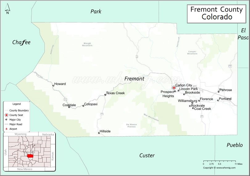
About Fremont County Map, Colorado: The map showing the county boundary, county seat, major cities, highways, water bodies and neighbouring counties.
Most Viewed Links
Map of Fremont County, Colorado
Fremont County is a county located in the U.S. state of Colorado. It's county seat is Cañon City. As per 2020 census, the population of Fremont County is 49661 people and population density is square miles. According to the United States Census Bureau, the county has a total area of 1,533.09 sq mi (3,971 km2). Fremont County was established on -13938.
Fremont County Facts
| Continent | North America |
| Country | United States |
| State | Colorado |
| County Seat | Canon City |
| Largest City/Town | Canon City |
| Established | 1861 |
| Total Area | 1,534 sq mi (3,973 sq km) |
| Land Area | 1,533 sq mi (3,970 sq km) |
| Water Area | 1 sq mi (3 sq km) |
| Population | 48,939 (Census 2020) |
| Population Density | 31.9 people per sq mi |
| Time Zone | Mountain Time Zone (MST/MDT) |
| Major Highways | US Highway 50, State Highway 9, State Highway 67, State Highway 115 |
| Major Rivers | Arkansas River |
| Neighboring Counties | Park County, Teller County, El Paso County, Pueblo County, Custer County, Saguache County, Chaffee County |
| Famous For | Royal Gorge, Arkansas River rafting, dinosaur fossils, and prison facilities |
| Top Attractions | Royal Gorge Bridge, Royal Gorge Route Railroad, Arkansas River, Dinosaur Depot Museum |
| Official Website | Official Website |
About Fremont County, Colorado
Fremont County is located in central Colorado in the United States and was established in 1861 as one of the original counties of the Colorado Territory. The county seat and largest city is Canon City. The county is known for dramatic canyon landscapes, river recreation, fossil discoveries, scenic railroads, and historic communities along the Arkansas River.
Cities and Towns in Fremont County, Colorado
| City/Town | Population (Census 2020) | Latitude & Longitude |
|---|---|---|
| Canon City (county seat) | 17,141 | 38.4494°N, 105.2253°W |
| Florence | 3,822 | 38.3908°N, 105.1172°W |
| Williamsburg | 714 | 38.3828°N, 104.9983°W |
| Brookside | 233 | 38.4806°N, 105.1964°W |
| Coal Creek | 343 | 38.3617°N, 105.1456°W |
| Rockvale | 511 | 38.3656°N, 105.1622°W |
| Penrose (CDP) | 3,685 | 38.4347°N, 105.0225°W |
| Lincoln Park (CDP) | 3,450 | 38.4700°N, 105.2122°W |
| Howard (CDP) | 723 | 38.4344°N, 105.8242°W |
| Cotopaxi (CDP) | 44 | 38.3706°N, 105.6925°W |
Golf Courses in Fremont County, Colorado
| Golf Course | Location | Latitude & Longitude |
|---|---|---|
| Four Mile Ranch Golf Club | Canon City | 38.4472°N, 105.2028°W |
| Shadow Hills Golf Club | Canon City | 38.4611°N, 105.2183°W |
| Desert Hawk Golf Course | Pueblo West nearby | 38.3497°N, 104.7203°W |
Roads and Highways in Fremont County, Colorado
Major highways connect the county to mountain valleys, southern Colorado cities, and recreation areas.
- US Highway 50 - major east-west route connecting Canon City with Pueblo, Salida, and western Colorado
- Colorado State Highway 9 - north-south highway connecting Fremont County with Park County and Custer County
- Colorado State Highway 67 - scenic highway linking Florence with Cripple Creek and Woodland Park
- Colorado State Highway 115 - route connecting Penrose and Canon City with Colorado Springs
Neighboring Counties of Fremont County
- Park County (north)
- Teller County (northwest)
- El Paso County (east)
- Pueblo County (southeast)
- Custer County (southwest)
- Saguache County (west)
- Chaffee County (northwest)
Top Attractions in Fremont County, Colorado
The county offers a mix of natural and historical attractions.
- Royal Gorge Bridge and Park - famous suspension bridge spanning the Arkansas River canyon
- Royal Gorge Route Railroad - scenic train rides through the Royal Gorge canyon
- Arkansas River Recreation Areas - rafting, kayaking, fishing, and hiking destinations
- Dinosaur Depot Museum - museum featuring dinosaur fossils and paleontology exhibits
- Florence Historic Main Street - antique shops, galleries, and preserved historic buildings
- Temple Canyon Park - hiking and rock climbing area with scenic canyon views
- Oil Well Flats Trail System - popular mountain biking and hiking trail network
- Phantom Canyon Road - scenic drive connecting Florence with Cripple Creek
- Garden Park Fossil Area - internationally known dinosaur fossil discovery site
- San Isabel National Forest access areas - camping, hiking, and mountain recreation
- Museum of Colorado Prisons - museum showcasing the history of Colorado correctional facilities
- Cotopaxi and Bighorn Sheep Canyon - rafting and wildlife viewing area along the Arkansas River
Distance from Fremont County to Nearby Cities
The following distances are measured by road (driving).
- Canon City to Pueblo (Pueblo County), Colorado - 40 mi (64 km)
- Canon City to Colorado Springs (El Paso County), Colorado - 45 mi (72 km)
- Canon City to Salida (Chaffee County), Colorado - 60 mi (97 km)
- Canon City to Denver (Denver County), Colorado - 118 mi (190 km)
- Canon City to Cripple Creek (Teller County), Colorado - 47 mi (76 km)
- Canon City to Westcliffe (Custer County), Colorado - 52 mi (84 km)
- Canon City to Breckenridge (Summit County), Colorado - 124 mi (200 km)
- Canon City to Gunnison (Gunnison County), Colorado - 135 mi (217 km)
- Canon City to Trinidad (Las Animas County), Colorado - 92 mi (148 km)
- Canon City to Grand Junction (Mesa County), Colorado - 240 mi (386 km)
- Canon City to Alamosa (Alamosa County), Colorado - 127 mi (204 km)
- Canon City to Estes Park (Larimer County), Colorado - 173 mi (278 km)
FAQs about Fremont County
Fremont County is located in central Colorado along the Arkansas River valley in the United States.
The population of Fremont County was 48,939 according to the Census 2020.
Fremont County is known for the Royal Gorge, Arkansas River rafting, dinosaur fossils, and scenic canyon landscapes.
The county is served by US Highway 50, Colorado State Highway 9, Colorado State Highway 67, and Colorado State Highway 115.
Yes, Fremont County has golf facilities including Four Mile Ranch Golf Club and Shadow Hills Golf Club.
References
- QuickFacts - U.S. Census Bureau
- United States Census Bureau
- United States Geological Survey (USGS)
- National Geodetic Survey
- Official Website
- Adams County Map
- Alamosa County Map
- Arapahoe County Map
- Archuleta County Map
- Baca County Map
- Bent County Map
- Boulder County Map
- Broomfield County Map
- Chaffee County Map
- Cheyenne County Map
- Clear Creek County Map
- Conejos County Map
- Costilla County Map
- Crowley County Map
- Custer County Map
- Delta County Map
- Denver County Map
- Dolores County Map
- Douglas County Map
- Eagle County Map
- Elbert County Map
- El Paso County Map
- Fremont County Map
- Garfield County Map
- Gilpin County Map
- Grand County Map
- Gunnison County Map
- Hinsdale County Map
- Huerfano County Map
- Jackson County Map
- Jefferson County Map
- Kiowa County Map
- Kit Carson County Map
- Lake County Map
- La Plata County Map
- Larimer County Map
- Las Animas County Map
- Lincoln County Map
- Logan County Map
- Mesa County Map
- Mineral County Map
- Moffat County Map
- Montezuma County Map
- Montrose County Map
- Morgan County Map
- Otero County Map
- Ouray County Map
- Park County Map
- Phillips County Map
- Pitkin County Map
- Prowers County Map
- Pueblo County Map
- Rio Blanco County Map
- Rio Grande County Map
- Routt County Map
- Saguache County Map
- San Juan County Map
- San Miguel County Map
- Sedgwick County Map
- Summit County Map
- Teller County Map
- Washington County Map
- Weld County Map
- Yuma County Map
- Alabama Counties
- Alaska boroughs
- Arizona Counties
- Arkansas Counties
- California County Map
- Colorado Counties
- Connecticut Counties
- Delaware Counties
- Florida County Map
- Georgia County Map
- Hawaii Counties
- Idaho Counties
- Illinois Counties
- Indiana Counties
- Iowa Counties
- Kansas Counties
- Kentucky Counties
- Louisiana Counties
- Maine Counties
- Maryland Counties
- Massachusetts Counties
- Michigan County Map
- Minnesota Counties
- Mississippi Counties
- Missouri Counties
- Montana Counties
- Nebraska Counties
- Nevada Counties
- New York Counties
- New Hampshire Counties
- New Jersey Counties
- New Mexico Counties
- North Carolina Counties
- North Dakota Counties
- Ohio County Map
- Oklahoma Counties
- Oregon Counties
- Pennsylvania Counties
- Rhode Island Counties
- South Carolina Counties
- South Dakota Counties
- Map of Tennessee
- Texas County Map
- Utah Counties
- Vermont Counties
- Virginia Counties
- Washington Counties
- West Virginia Counties
- Wisconsin Counties
- Wyoming Counties