Map of Douglas County - Douglas County is a county located in the U.S. state of Colorado. Douglas County Map showing cities, highways, important places and water bodies. Get Where is Douglas County located in the map, major cities in Douglas county, population, areas, and places of interest.
Map of Douglas County, Colorado
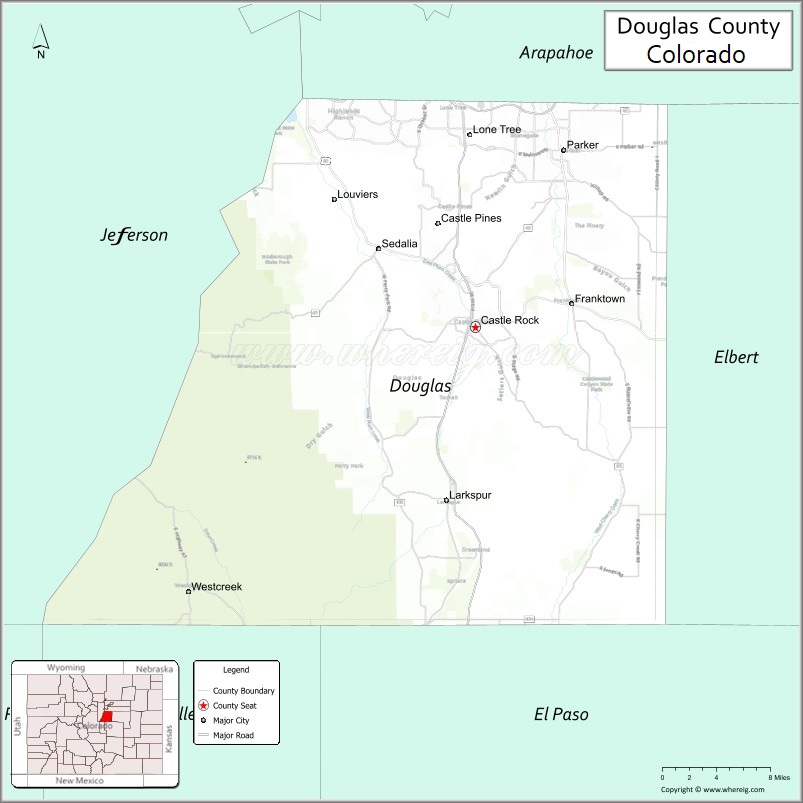
About Douglas County Map, Colorado: The map showing the county boundary, county seat, major cities, highways, water bodies and neighbouring counties.
Most Viewed Links
Map of Douglas County, Colorado
Douglas County is a county located in the U.S. state of Colorado. It's county seat is Castle Rock. As per 2020 census, the population of Douglas County is 368990 people and population density is square miles. According to the United States Census Bureau, the county has a total area of 842.30 sq mi (2,182 km2). Douglas County was established on -13938.
Douglas County Facts
| Continent | North America |
| Country | United States |
| State | Colorado |
| County Seat | Castle Rock |
| Largest City/Town | Castle Rock |
| Established | 1861 |
| Total Area | 844 sq mi (2,186 sq km) |
| Land Area | 840 sq mi (2,176 sq km) |
| Water Area | 4 sq mi (10 sq km) |
| Population | 357,978 (Census 2020) |
| Population Density | 426.2 people per sq mi |
| Time Zone | Mountain Time Zone (MST/MDT) |
| Major Highways | Interstate 25, E-470, US Highway 85, State Highway 83, State Highway 86 |
| Major Rivers | South Platte River, Cherry Creek |
| Neighboring Counties | Denver County, Arapahoe County, Elbert County, El Paso County, Jefferson County, Park County, Teller County |
| Famous For | Suburban communities, Castle Rock, outdoor recreation, and Denver metropolitan growth |
| Top Attractions | Castlewood Canyon State Park, Roxborough State Park nearby, Park Meadows Mall, Daniels Park |
| Official Website | Official Website |
About Douglas County, Colorado
Douglas County is located in north-central Colorado in the United States and was established in 1861 as one of the original counties of the Colorado Territory. The county seat and largest town is Castle Rock. The county is known for rapidly growing suburban communities, scenic open spaces, parks, trails, and its location between Denver and Colorado Springs.
Cities and Towns in Douglas County, Colorado
| City/Town | Population (Census 2020) | Latitude & Longitude |
|---|---|---|
| Castle Rock (county seat) | 73,158 | 39.3722°N, 104.8561°W |
| Parker | 58,512 | 39.5186°N, 104.7614°W |
| Lone Tree | 14,253 | 39.5539°N, 104.8897°W |
| Castle Pines | 11,773 | 39.4603°N, 104.8969°W |
| Highlands Ranch (CDP) | 105,631 | 39.5539°N, 104.9694°W |
| Franktown (CDP) | 396 | 39.3892°N, 104.7525°W |
| Larkspur | 183 | 39.2275°N, 104.8947°W |
| Louviers (CDP) | 264 | 39.4769°N, 105.0086°W |
| Sedalia (CDP) | 177 | 39.4372°N, 104.9597°W |
| The Pinery (CDP) | 10,315 | 39.4556°N, 104.7342°W |
Golf Courses in Douglas County, Colorado
| Golf Course | Location | Latitude & Longitude |
|---|---|---|
| Castle Pines Golf Club | Castle Rock | 39.4606°N, 104.8939°W |
| The Ridge at Castle Pines North | Castle Pines | 39.4669°N, 104.8964°W |
| Red Hawk Ridge Golf Course | Castle Rock | 39.3689°N, 104.8853°W |
| Plum Creek Golf Club | Castle Rock | 39.3436°N, 104.8639°W |
| Highlands Ranch Golf Club | Highlands Ranch | 39.5447°N, 104.9806°W |
| The Pinery Country Club | Parker | 39.4578°N, 104.7328°W |
| Colorado Golf Club | Parker | 39.4644°N, 104.6828°W |
Roads and Highways in Douglas County, Colorado
Major highways connect the county to Denver, Colorado Springs, and surrounding suburban communities.
- Interstate 25 - major north-south interstate connecting Castle Rock with Denver and Colorado Springs
- E-470 - toll highway connecting Douglas County with Denver International Airport and metro suburbs
- US Highway 85 - regional route connecting Sedalia and southern Denver metro communities
- Colorado State Highway 83 - scenic route linking Parker with Colorado Springs
- Colorado State Highway 86 - east-west route connecting Castle Rock with Franktown and eastern plains areas
Neighboring Counties of Douglas County
- Denver County (north)
- Arapahoe County (northeast)
- Elbert County (east)
- El Paso County (south)
- Teller County (southwest)
- Park County (west)
- Jefferson County (northwest)
Top Attractions in Douglas County, Colorado
The county offers a mix of natural and cultural attractions.
- Castlewood Canyon State Park - scenic canyon park with hiking trails, waterfalls, and historic ruins
- Daniels Park - open space area with mountain views and bison herds
- Park Meadows Mall - major shopping and entertainment destination in Lone Tree
- Roxborough State Park nearby - famous red rock formations and hiking trails
- Philip S. Miller Park - recreation area with trails, amphitheater, and adventure playground
- Castle Rock Outlets - large outlet shopping center along Interstate 25
- Bluffs Regional Park Trail - scenic trail system overlooking the Denver metro area
- Rueter-Hess Reservoir - recreation and wildlife viewing destination near Parker
- Chatfield State Park nearby - reservoir recreation area with boating and camping
- High Line Canal Trail - regional trail popular for biking and walking
- Larkspur Historical Society Museum - local history museum featuring ranching and pioneer exhibits
- Devil's Head Lookout Trail - mountain hiking trail leading to a historic fire lookout tower
Distance from Douglas County to Nearby Cities
The following distances are measured by road (driving).
- Castle Rock to Denver (Denver County), Colorado - 31 mi (50 km)
- Castle Rock to Colorado Springs (El Paso County), Colorado - 41 mi (66 km)
- Castle Rock to Parker (Douglas County), Colorado - 15 mi (24 km)
- Castle Rock to Boulder (Boulder County), Colorado - 54 mi (87 km)
- Castle Rock to Golden (Jefferson County), Colorado - 36 mi (58 km)
- Castle Rock to Aurora (Arapahoe County), Colorado - 29 mi (47 km)
- Castle Rock to Pueblo (Pueblo County), Colorado - 84 mi (135 km)
- Castle Rock to Fort Collins (Larimer County), Colorado - 96 mi (154 km)
- Castle Rock to Breckenridge (Summit County), Colorado - 87 mi (140 km)
- Castle Rock to Canon City (Fremont County), Colorado - 77 mi (124 km)
- Castle Rock to Limon (Lincoln County), Colorado - 80 mi (129 km)
- Castle Rock to Estes Park (Larimer County), Colorado - 96 mi (154 km)
FAQs about Douglas County
Douglas County is located in north-central Colorado between Denver and Colorado Springs in the United States.
The population of Douglas County was 357,978 according to the Census 2020.
Douglas County is known for suburban communities, parks, open spaces, golf courses, and rapid residential growth.
The county is served by Interstate 25, E-470, US Highway 85, Colorado State Highway 83, and Colorado State Highway 86.
Yes, Douglas County has several golf courses including Castle Pines Golf Club, Plum Creek Golf Club, and Highlands Ranch Golf Club.
References
- QuickFacts - U.S. Census Bureau
- United States Census Bureau
- United States Geological Survey (USGS)
- National Geodetic Survey
- Official Website
- Adams County Map
- Alamosa County Map
- Arapahoe County Map
- Archuleta County Map
- Baca County Map
- Bent County Map
- Boulder County Map
- Broomfield County Map
- Chaffee County Map
- Cheyenne County Map
- Clear Creek County Map
- Conejos County Map
- Costilla County Map
- Crowley County Map
- Custer County Map
- Delta County Map
- Denver County Map
- Dolores County Map
- Douglas County Map
- Eagle County Map
- Elbert County Map
- El Paso County Map
- Fremont County Map
- Garfield County Map
- Gilpin County Map
- Grand County Map
- Gunnison County Map
- Hinsdale County Map
- Huerfano County Map
- Jackson County Map
- Jefferson County Map
- Kiowa County Map
- Kit Carson County Map
- Lake County Map
- La Plata County Map
- Larimer County Map
- Las Animas County Map
- Lincoln County Map
- Logan County Map
- Mesa County Map
- Mineral County Map
- Moffat County Map
- Montezuma County Map
- Montrose County Map
- Morgan County Map
- Otero County Map
- Ouray County Map
- Park County Map
- Phillips County Map
- Pitkin County Map
- Prowers County Map
- Pueblo County Map
- Rio Blanco County Map
- Rio Grande County Map
- Routt County Map
- Saguache County Map
- San Juan County Map
- San Miguel County Map
- Sedgwick County Map
- Summit County Map
- Teller County Map
- Washington County Map
- Weld County Map
- Yuma County Map
- Alabama Counties
- Alaska boroughs
- Arizona Counties
- Arkansas Counties
- California County Map
- Colorado Counties
- Connecticut Counties
- Delaware Counties
- Florida County Map
- Georgia County Map
- Hawaii Counties
- Idaho Counties
- Illinois Counties
- Indiana Counties
- Iowa Counties
- Kansas Counties
- Kentucky Counties
- Louisiana Counties
- Maine Counties
- Maryland Counties
- Massachusetts Counties
- Michigan County Map
- Minnesota Counties
- Mississippi Counties
- Missouri Counties
- Montana Counties
- Nebraska Counties
- Nevada Counties
- New York Counties
- New Hampshire Counties
- New Jersey Counties
- New Mexico Counties
- North Carolina Counties
- North Dakota Counties
- Ohio County Map
- Oklahoma Counties
- Oregon Counties
- Pennsylvania Counties
- Rhode Island Counties
- South Carolina Counties
- South Dakota Counties
- Map of Tennessee
- Texas County Map
- Utah Counties
- Vermont Counties
- Virginia Counties
- Washington Counties
- West Virginia Counties
- Wisconsin Counties
- Wyoming Counties