Map of Logan County - Logan County is a county located in the U.S. state of Colorado. Logan County Map showing cities, highways, important places and water bodies. Get Where is Logan County located in the map, major cities in Logan county, population, areas, and places of interest.
Map of Logan County, Colorado
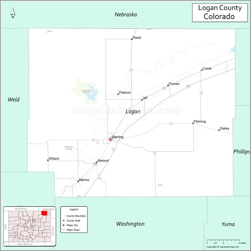
About Logan County Map, Colorado: The map showing the county boundary, county seat, major cities, highways, water bodies and neighbouring counties.
Most Viewed Links
Map of Logan County, Colorado
Logan County is a county located in the U.S. state of Colorado. It's county seat is Sterling. As per 2020 census, the population of Logan County is 21487 people and population density is square miles. According to the United States Census Bureau, the county has a total area of 1,845.31 sq mi (4,779 km2). Logan County was established on -4691.
Logan County Facts
| Continent | North America |
| Country | United States |
| State | Colorado |
| County Seat | Sterling |
| Largest City/Town | Sterling |
| Established | 1887 |
| Total Area | 1,845 sq mi (4,779 sq km) |
| Land Area | 1,839 sq mi (4,763 sq km) |
| Water Area | 6 sq mi (16 sq km) |
| Population | 21,928 (Census 2020) |
| Population Density | 11.9 people per sq mi |
| Time Zone | Mountain Time Zone (MST/MDT) |
| Major Highways | Interstate 76, US Highway 6, State Highway 14, State Highway 71 |
| Major Rivers | South Platte River |
| Neighboring Counties | Sedgwick County, Phillips County, Washington County, Morgan County, Weld County |
| Famous For | Agriculture, Sterling, South Platte River valley, and northeastern Colorado prairie landscapes |
| Top Attractions | North Sterling State Park, Overland Trail Museum, South Platte River, Prairie Trails Scenic Byway |
| Official Website | Official Website |
About Logan County, Colorado
Logan County is located in northeastern Colorado in the United States and was established in 1887. The county seat and largest city is Sterling. The county is known for agriculture, irrigation farming, prairie landscapes, outdoor recreation, and historic transportation routes across the High Plains.
Cities and Towns in Logan County, Colorado
| City/Town | Population (Census 2020) | Latitude & Longitude |
|---|---|---|
| Sterling (county seat) | 13,735 | 40.6255°N, 103.2077°W |
| Fleming | 428 | 40.6797°N, 102.8322°W |
| Crook | 110 | 40.8481°N, 102.8019°W |
| Iliff | 267 | 40.7694°N, 103.0447°W |
| Merino | 284 | 40.4842°N, 103.3519°W |
| Peetz (partly) | 170 | 40.9647°N, 103.1081°W |
| Padroni | 80 | 40.7739°N, 103.1111°W |
| Stoneham | 20 | 40.6147°N, 103.6228°W |
Golf Courses in Logan County, Colorado
| Golf Course | Location | Latitude & Longitude |
|---|---|---|
| Sky Ranch Golf Course | Sterling | 40.6203°N, 103.2014°W |
| Riverview Golf Club | Sterling | 40.6297°N, 103.2153°W |
| Holyoke Country Club | Holyoke nearby | 40.5822°N, 102.3008°W |
Roads and Highways in Logan County, Colorado
Major highways connect the county to northeastern Colorado communities and interstate transportation routes.
- Interstate 76 - major interstate connecting Sterling with Denver and Nebraska
- US Highway 6 - historic east-west highway serving Sterling and surrounding agricultural areas
- Colorado State Highway 14 - route linking Sterling with Fort Collins and northeastern Colorado towns
- Colorado State Highway 71 - north-south highway crossing eastern Colorado plains
Neighboring Counties of Logan County
- Sedgwick County (east)
- Phillips County (northeast)
- Washington County (south)
- Morgan County (southwest)
- Weld County (west)
Top Attractions in Logan County, Colorado
The county offers a mix of outdoor, historical, and prairie attractions.
- North Sterling State Park - reservoir recreation area for boating, fishing, and camping
- Overland Trail Museum - museum featuring pioneer history, railroads, and prairie life
- South Platte River recreation areas - fishing, wildlife viewing, and outdoor activities
- Prairie Trails Scenic Byway - scenic driving route across northeastern Colorado plains
- Sterling Historic Downtown - local shops, restaurants, and preserved architecture
- Logan County Fairgrounds - venue for rodeos, agricultural fairs, and community events
- Pawnee Pioneer Trails region nearby - historic routes and prairie landscapes
- Prewitt Reservoir nearby - fishing and wildlife recreation destination
- High Plains agricultural landscapes - irrigation farming and prairie scenery
- Riverside Park in Sterling - recreation area with trails and picnic spaces
- Historic Railroad Sites - rail history connected to Sterling and northeastern Colorado
- Prairie Wildlife Viewing Areas - habitat for migratory birds, deer, and pronghorn
Distance from Logan County to Nearby Cities
The following distances are measured by road (driving).
- Sterling to Fort Collins (Larimer County), Colorado - 92 mi (148 km)
- Sterling to Denver (Denver County), Colorado - 128 mi (206 km)
- Sterling to Greeley (Weld County), Colorado - 74 mi (119 km)
- Sterling to Holyoke (Phillips County), Colorado - 62 mi (100 km)
- Sterling to Sidney (Cheyenne County), Nebraska - 74 mi (119 km)
- Sterling to Cheyenne (Laramie County), Wyoming - 103 mi (166 km)
- Sterling to North Platte (Lincoln County), Nebraska - 143 mi (230 km)
- Sterling to Colorado Springs (El Paso County), Colorado - 197 mi (317 km)
- Sterling to Grand Junction (Mesa County), Colorado - 358 mi (576 km)
- Sterling to Scottsbluff (Scotts Bluff County), Nebraska - 96 mi (154 km)
- Sterling to Wichita (Sedgwick County), Kansas - 404 mi (650 km)
- Sterling to Omaha (Douglas County), Nebraska - 375 mi (604 km)
FAQs about Logan County
Logan County is located in northeastern Colorado within the High Plains region of the United States.
The population of Logan County was 21,928 according to the Census 2020.
Logan County is known for agriculture, Sterling, prairie landscapes, and outdoor recreation along the South Platte River.
The county is served by Interstate 76, US Highway 6, Colorado State Highway 14, and Colorado State Highway 71.
Popular attractions include North Sterling State Park, the Overland Trail Museum, the South Platte River, and prairie scenic byways.
References
- QuickFacts - U.S. Census Bureau
- United States Census Bureau
- United States Geological Survey (USGS)
- National Geodetic Survey
- Official Website
- Adams County Map
- Alamosa County Map
- Arapahoe County Map
- Archuleta County Map
- Baca County Map
- Bent County Map
- Boulder County Map
- Broomfield County Map
- Chaffee County Map
- Cheyenne County Map
- Clear Creek County Map
- Conejos County Map
- Costilla County Map
- Crowley County Map
- Custer County Map
- Delta County Map
- Denver County Map
- Dolores County Map
- Douglas County Map
- Eagle County Map
- Elbert County Map
- El Paso County Map
- Fremont County Map
- Garfield County Map
- Gilpin County Map
- Grand County Map
- Gunnison County Map
- Hinsdale County Map
- Huerfano County Map
- Jackson County Map
- Jefferson County Map
- Kiowa County Map
- Kit Carson County Map
- Lake County Map
- La Plata County Map
- Larimer County Map
- Las Animas County Map
- Lincoln County Map
- Logan County Map
- Mesa County Map
- Mineral County Map
- Moffat County Map
- Montezuma County Map
- Montrose County Map
- Morgan County Map
- Otero County Map
- Ouray County Map
- Park County Map
- Phillips County Map
- Pitkin County Map
- Prowers County Map
- Pueblo County Map
- Rio Blanco County Map
- Rio Grande County Map
- Routt County Map
- Saguache County Map
- San Juan County Map
- San Miguel County Map
- Sedgwick County Map
- Summit County Map
- Teller County Map
- Washington County Map
- Weld County Map
- Yuma County Map
- Alabama Counties
- Alaska boroughs
- Arizona Counties
- Arkansas Counties
- California County Map
- Colorado Counties
- Connecticut Counties
- Delaware Counties
- Florida County Map
- Georgia County Map
- Hawaii Counties
- Idaho Counties
- Illinois Counties
- Indiana Counties
- Iowa Counties
- Kansas Counties
- Kentucky Counties
- Louisiana Counties
- Maine Counties
- Maryland Counties
- Massachusetts Counties
- Michigan County Map
- Minnesota Counties
- Mississippi Counties
- Missouri Counties
- Montana Counties
- Nebraska Counties
- Nevada Counties
- New York Counties
- New Hampshire Counties
- New Jersey Counties
- New Mexico Counties
- North Carolina Counties
- North Dakota Counties
- Ohio County Map
- Oklahoma Counties
- Oregon Counties
- Pennsylvania Counties
- Rhode Island Counties
- South Carolina Counties
- South Dakota Counties
- Map of Tennessee
- Texas County Map
- Utah Counties
- Vermont Counties
- Virginia Counties
- Washington Counties
- West Virginia Counties
- Wisconsin Counties
- Wyoming Counties