Map of Archuleta County - Archuleta County is a county located in the U.S. state of Colorado. Archuleta County Map showing cities, highways, important places and water bodies. Get Where is Archuleta County located in the map, major cities in Archuleta county, population, areas, and places of interest.
Map of Archuleta County, Colorado
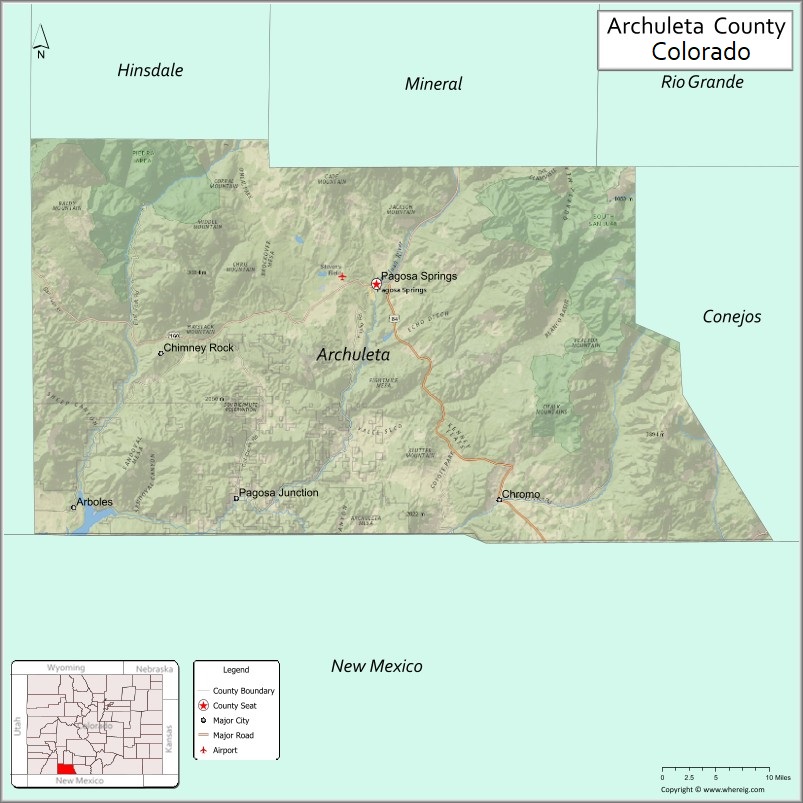
About Archuleta County Map, Colorado: The map showing the county boundary, county seat, major cities, highways, water bodies and neighbouring counties.
Most Viewed Links
Map of Archuleta County, Colorado
Archuleta County is a county located in the U.S. state of Colorado. It's county seat is Pagosa Springs. As per 2020 census, the population of Archuleta County is 13790 people and population density is square miles. According to the United States Census Bureau, the county has a total area of 1,354.53 sq mi (3,508 km2). Archuleta County was established on -5373.
Archuleta County Facts
| Continent | North America |
| Country | United States |
| State | Colorado |
| County Seat | Pagosa Springs |
| Largest City/Town | Pagosa Springs |
| Established | 1885 |
| Total Area | 1,356 sq mi (3,512 sq km) |
| Land Area | 1,350 sq mi (3,496 sq km) |
| Water Area | 6 sq mi (16 sq km) |
| Population | 13,359 (Census 2020) |
| Population Density | 9.9 people per sq mi |
| Time Zone | Mountain Time Zone (MST/MDT) |
| Major Highways | US Highway 160, State Highway 84 |
| Major Rivers | San Juan River, Piedra River |
| Neighboring Counties | Hinsdale County, Mineral County, Rio Grande County, Conejos County, La Plata County |
| Famous For | Pagosa Springs hot springs, San Juan National Forest, mountain scenery, and outdoor recreation |
| Top Attractions | Pagosa Hot Springs, Wolf Creek Pass, San Juan National Forest, Chimney Rock National Monument |
| Official Website | Official Website |
About Archuleta County, Colorado
Archuleta County is located in the southwestern part of Colorado in the United States and was established in 1885. The county seat and largest town is Pagosa Springs. The county is known for its mountain landscapes, forests, rivers, hot springs, and year-round outdoor recreation opportunities in the San Juan Mountains region.
Cities and Towns in Archuleta County, Colorado
| City/Town | Population (Census 2020) | Latitude & Longitude |
|---|---|---|
| Pagosa Springs (county seat) | 1,571 | 37.2694°N, 107.0098°W |
| Arboles (CDP) | 308 | 37.0289°N, 107.4198°W |
| Chromo (CDP) | 118 | 37.0369°N, 106.8431°W |
| Pagosa Springs West (CDP) | 1,884 | 37.2961°N, 107.0958°W |
| Piedra (CDP) | 14 | 37.2236°N, 107.3408°W |
Golf Courses in Archuleta County, Colorado
| Golf Course | Location | Latitude & Longitude |
|---|---|---|
| Pagosa Springs Golf Club | Pagosa Springs | 37.2928°N, 107.0731°W |
| Cloman Park Disc Golf Course | Pagosa Springs | 37.2639°N, 107.0178°W |
Roads and Highways in Archuleta County, Colorado
Major highways connect the county to mountain communities and nearby regions of Colorado and New Mexico.
- US Highway 160 - major east-west highway connecting Pagosa Springs with Durango and Alamosa
- Colorado State Highway 84 - southbound route connecting Pagosa Springs with Chama, New Mexico
Neighboring Counties of Archuleta County
- Hinsdale County (north)
- Mineral County (northeast)
- Rio Grande County (east)
- Conejos County (southeast)
- La Plata County (west)
Top Attractions in Archuleta County, Colorado
The county offers a mix of natural and cultural attractions.
- Pagosa Hot Springs - famous geothermal hot springs resort along the San Juan River
- San Juan National Forest - expansive forest area with hiking, camping, and scenic drives
- Wolf Creek Pass - scenic mountain pass known for skiing and mountain views
- Chimney Rock National Monument - archaeological site with ancient Puebloan ruins
- Treasure Falls - popular waterfall hiking destination near US Highway 160
- Williams Creek Reservoir - fishing and boating area surrounded by mountain scenery
- Piedra River Trail - scenic hiking trail along the Piedra River canyon
- Reservoir Hill Park - local recreation area with hiking and mountain biking trails
- Navajo Lake State Park - nearby recreation area popular for boating and fishing
- Fred Harman Art Museum - museum dedicated to the creator of the Red Ryder comic strip
- Rocky Mountain Wildlife Park - wildlife attraction featuring native Colorado animals
- Turkey Springs Trail System - outdoor recreation area popular for mountain biking and hiking
Distance from Archuleta County to Nearby Cities
The following distances are measured by road (driving).
- Pagosa Springs to Durango (La Plata County), Colorado - 60 mi (97 km)
- Pagosa Springs to Alamosa (Alamosa County), Colorado - 119 mi (192 km)
- Pagosa Springs to Cortez (Montezuma County), Colorado - 106 mi (171 km)
- Pagosa Springs to Farmington (San Juan County), New Mexico - 103 mi (166 km)
- Pagosa Springs to Chama (Rio Arriba County), New Mexico - 52 mi (84 km)
- Pagosa Springs to Santa Fe (Santa Fe County), New Mexico - 170 mi (274 km)
- Pagosa Springs to Gunnison (Gunnison County), Colorado - 176 mi (283 km)
- Pagosa Springs to Colorado Springs (El Paso County), Colorado - 256 mi (412 km)
- Pagosa Springs to Denver (Denver County), Colorado - 285 mi (459 km)
- Pagosa Springs to Montrose (Montrose County), Colorado - 153 mi (246 km)
- Pagosa Springs to Telluride (San Miguel County), Colorado - 131 mi (211 km)
- Pagosa Springs to Taos (Taos County), New Mexico - 129 mi (208 km)
FAQs about Archuleta County
Archuleta County is located in southwestern Colorado near the New Mexico border in the United States.
The population of Archuleta County was 13,359 according to the Census 2020.
Archuleta County is known for Pagosa Springs hot springs, mountain scenery, forests, and outdoor recreation activities.
The county is mainly served by US Highway 160 and Colorado State Highway 84.
Yes, Archuleta County has golf facilities including Pagosa Springs Golf Club near Pagosa Springs.
References
- QuickFacts - U.S. Census Bureau
- United States Census Bureau
- United States Geological Survey (USGS)
- National Geodetic Survey
- Official County Website
- Adams County Map
- Alamosa County Map
- Arapahoe County Map
- Archuleta County Map
- Baca County Map
- Bent County Map
- Boulder County Map
- Broomfield County Map
- Chaffee County Map
- Cheyenne County Map
- Clear Creek County Map
- Conejos County Map
- Costilla County Map
- Crowley County Map
- Custer County Map
- Delta County Map
- Denver County Map
- Dolores County Map
- Douglas County Map
- Eagle County Map
- Elbert County Map
- El Paso County Map
- Fremont County Map
- Garfield County Map
- Gilpin County Map
- Grand County Map
- Gunnison County Map
- Hinsdale County Map
- Huerfano County Map
- Jackson County Map
- Jefferson County Map
- Kiowa County Map
- Kit Carson County Map
- Lake County Map
- La Plata County Map
- Larimer County Map
- Las Animas County Map
- Lincoln County Map
- Logan County Map
- Mesa County Map
- Mineral County Map
- Moffat County Map
- Montezuma County Map
- Montrose County Map
- Morgan County Map
- Otero County Map
- Ouray County Map
- Park County Map
- Phillips County Map
- Pitkin County Map
- Prowers County Map
- Pueblo County Map
- Rio Blanco County Map
- Rio Grande County Map
- Routt County Map
- Saguache County Map
- San Juan County Map
- San Miguel County Map
- Sedgwick County Map
- Summit County Map
- Teller County Map
- Washington County Map
- Weld County Map
- Yuma County Map
- Alabama Counties
- Alaska boroughs
- Arizona Counties
- Arkansas Counties
- California County Map
- Colorado Counties
- Connecticut Counties
- Delaware Counties
- Florida County Map
- Georgia County Map
- Hawaii Counties
- Idaho Counties
- Illinois Counties
- Indiana Counties
- Iowa Counties
- Kansas Counties
- Kentucky Counties
- Louisiana Counties
- Maine Counties
- Maryland Counties
- Massachusetts Counties
- Michigan County Map
- Minnesota Counties
- Mississippi Counties
- Missouri Counties
- Montana Counties
- Nebraska Counties
- Nevada Counties
- New York Counties
- New Hampshire Counties
- New Jersey Counties
- New Mexico Counties
- North Carolina Counties
- North Dakota Counties
- Ohio County Map
- Oklahoma Counties
- Oregon Counties
- Pennsylvania Counties
- Rhode Island Counties
- South Carolina Counties
- South Dakota Counties
- Map of Tennessee
- Texas County Map
- Utah Counties
- Vermont Counties
- Virginia Counties
- Washington Counties
- West Virginia Counties
- Wisconsin Counties
- Wyoming Counties