Map of Kiowa County - Kiowa County is a county located in the U.S. state of Colorado. Kiowa County Map showing cities, highways, important places and water bodies. Get Where is Kiowa County located in the map, major cities in Kiowa county, population, areas, and places of interest.
Map of Kiowa County, Colorado
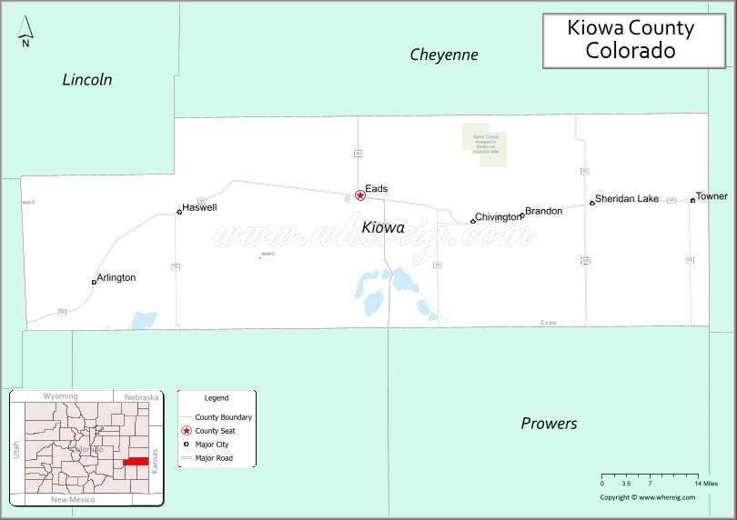
About Kiowa County Map, Colorado: The map showing the county boundary, county seat, major cities, highways, water bodies and neighbouring counties.
Most Viewed Links
Map of Kiowa County, Colorado
Kiowa County is a county located in the U.S. state of Colorado. It's county seat is Eads. As per 2020 census, the population of Kiowa County is 1452 people and population density is square miles. According to the United States Census Bureau, the county has a total area of 1,785.90 sq mi (4,625 km2). Kiowa County was established on -3915.
Kiowa County Facts
| Continent | North America |
| Country | United States |
| State | Colorado |
| County Seat | Eads |
| Largest City/Town | Eads |
| Established | 1889 |
| Total Area | 1,786 sq mi (4,626 sq km) |
| Land Area | 1,768 sq mi (4,579 sq km) |
| Water Area | 18 sq mi (47 sq km) |
| Population | 1,446 (Census 2020) |
| Population Density | 0.8 people per sq mi |
| Time Zone | Mountain Time Zone (MST/MDT) |
| Major Highways | US Highway 287, State Highway 96 |
| Major Rivers | Arkansas River watershed, Big Sandy Creek |
| Neighboring Counties | Crowley County, Bent County, Prowers County, Cheyenne County, Lincoln County |
| Famous For | Great Plains landscapes, ranching, farming, Sand Creek Massacre history, and prairie wildlife |
| Top Attractions | Sand Creek Massacre National Historic Site, Big Sandy Creek, Eads museums, prairie scenery |
| Official Website | Official Website |
About Kiowa County, Colorado
Kiowa County is located in southeastern Colorado in the United States and was established in 1889. The county seat and largest town is Eads. The county is known for open prairie landscapes, agriculture, ranching, wildlife habitats, and historical sites connected to the American West.
Cities and Communities in Kiowa County, Colorado
| City/Town | Population (Census 2020) | Latitude & Longitude |
|---|---|---|
| Eads (county seat) | 672 | 38.4806°N, 102.7781°W |
| Sheridan Lake | 66 | 38.4711°N, 102.2936°W |
| Towner | 20 | 38.4736°N, 102.6842°W |
| Arlington (historic community) | Historic site | 38.3425°N, 103.3450°W |
| Brandon (CDP) | 21 | 38.4600°N, 102.4472°W |
| Chivington (historic community) | Historic site | 38.4792°N, 102.5414°W |
Golf Courses in Kiowa County, Colorado
| Golf Course | Location | Latitude & Longitude |
|---|---|---|
| Eads Golf Course | Eads | 38.4825°N, 102.7803°W |
| Spreading Antlers Golf Course | Lamar nearby | 38.0872°N, 102.6200°W |
| Rocky Ford Country Club | Rocky Ford nearby | 38.0528°N, 103.7208°W |
Roads and Highways in Kiowa County, Colorado
Major highways connect the county to southeastern Colorado communities and regional agricultural areas.
- US Highway 287 - north-south highway connecting Eads with Lamar and Kit Carson
- Colorado State Highway 96 - east-west route linking Kiowa County with Pueblo and Kansas border communities
Neighboring Counties of Kiowa County
- Lincoln County (north)
- Cheyenne County (east)
- Prowers County (southeast)
- Bent County (southwest)
- Crowley County (west)
Top Attractions in Kiowa County, Colorado
The county offers a mix of historical and prairie attractions.
- Sand Creek Massacre National Historic Site - historic site commemorating an important event in American history
- Big Sandy Creek - scenic prairie waterway known for wildlife and photography
- Eads Heritage Museum - local museum featuring pioneer, railroad, and ranching history
- Kiowa County Fairgrounds - venue hosting rodeos, fairs, and agricultural events
- Comanche National Grassland nearby - prairie recreation area with birdwatching and hiking opportunities
- Prairie Wildlife Viewing Areas - habitat for pronghorn, deer, and migratory birds
- Historic Railroad Sites - remnants of rail lines important to southeastern Colorado settlement
- Old Chivington Area - historical community connected to frontier history
- Sheridan Lake Recreation Areas - fishing and outdoor recreation opportunities
- Colorado Plains Scenic Drives - rural landscapes and open prairie scenery
- Agricultural Heritage Sites - ranching and farming landmarks throughout the county
- Dark Sky Viewing Areas - remote plains locations known for excellent stargazing conditions
Distance from Kiowa County to Nearby Cities
The following distances are measured by road (driving).
- Eads to Lamar (Prowers County), Colorado - 61 mi (98 km)
- Eads to Pueblo (Pueblo County), Colorado - 114 mi (183 km)
- Eads to Colorado Springs (El Paso County), Colorado - 154 mi (248 km)
- Eads to La Junta (Otero County), Colorado - 71 mi (114 km)
- Eads to Kit Carson (Cheyenne County), Colorado - 74 mi (119 km)
- Eads to Dodge City (Ford County), Kansas - 131 mi (211 km)
- Eads to Denver (Denver County), Colorado - 207 mi (333 km)
- Eads to Garden City (Finney County), Kansas - 144 mi (232 km)
- Eads to Trinidad (Las Animas County), Colorado - 161 mi (259 km)
- Eads to Burlington (Kit Carson County), Colorado - 115 mi (185 km)
- Eads to Wichita (Sedgwick County), Kansas - 275 mi (443 km)
- Eads to Amarillo (Potter County), Texas - 295 mi (475 km)
FAQs about Kiowa County
Kiowa County is located in southeastern Colorado within the Great Plains region of the United States.
The population of Kiowa County was 1,446 according to the Census 2020.
Kiowa County is known for prairie landscapes, ranching, farming, and the Sand Creek Massacre National Historic Site.
The county is served by US Highway 287 and Colorado State Highway 96.
Popular attractions include Sand Creek Massacre National Historic Site, Big Sandy Creek, prairie wildlife areas, and local heritage museums.
References
- QuickFacts - U.S. Census Bureau
- United States Census Bureau
- United States Geological Survey (USGS)
- National Geodetic Survey
- Official Website
- Adams County Map
- Alamosa County Map
- Arapahoe County Map
- Archuleta County Map
- Baca County Map
- Bent County Map
- Boulder County Map
- Broomfield County Map
- Chaffee County Map
- Cheyenne County Map
- Clear Creek County Map
- Conejos County Map
- Costilla County Map
- Crowley County Map
- Custer County Map
- Delta County Map
- Denver County Map
- Dolores County Map
- Douglas County Map
- Eagle County Map
- Elbert County Map
- El Paso County Map
- Fremont County Map
- Garfield County Map
- Gilpin County Map
- Grand County Map
- Gunnison County Map
- Hinsdale County Map
- Huerfano County Map
- Jackson County Map
- Jefferson County Map
- Kiowa County Map
- Kit Carson County Map
- Lake County Map
- La Plata County Map
- Larimer County Map
- Las Animas County Map
- Lincoln County Map
- Logan County Map
- Mesa County Map
- Mineral County Map
- Moffat County Map
- Montezuma County Map
- Montrose County Map
- Morgan County Map
- Otero County Map
- Ouray County Map
- Park County Map
- Phillips County Map
- Pitkin County Map
- Prowers County Map
- Pueblo County Map
- Rio Blanco County Map
- Rio Grande County Map
- Routt County Map
- Saguache County Map
- San Juan County Map
- San Miguel County Map
- Sedgwick County Map
- Summit County Map
- Teller County Map
- Washington County Map
- Weld County Map
- Yuma County Map
- Alabama Counties
- Alaska boroughs
- Arizona Counties
- Arkansas Counties
- California County Map
- Colorado Counties
- Connecticut Counties
- Delaware Counties
- Florida County Map
- Georgia County Map
- Hawaii Counties
- Idaho Counties
- Illinois Counties
- Indiana Counties
- Iowa Counties
- Kansas Counties
- Kentucky Counties
- Louisiana Counties
- Maine Counties
- Maryland Counties
- Massachusetts Counties
- Michigan County Map
- Minnesota Counties
- Mississippi Counties
- Missouri Counties
- Montana Counties
- Nebraska Counties
- Nevada Counties
- New York Counties
- New Hampshire Counties
- New Jersey Counties
- New Mexico Counties
- North Carolina Counties
- North Dakota Counties
- Ohio County Map
- Oklahoma Counties
- Oregon Counties
- Pennsylvania Counties
- Rhode Island Counties
- South Carolina Counties
- South Dakota Counties
- Map of Tennessee
- Texas County Map
- Utah Counties
- Vermont Counties
- Virginia Counties
- Washington Counties
- West Virginia Counties
- Wisconsin Counties
- Wyoming Counties