Map of Washington County - Washington County is a county located in the U.S. state of Colorado. Washington County Map showing cities, highways, important places and water bodies. Get Where is Washington County located in the map, major cities in Washington county, population, areas, and places of interest.
Map of Washington County, Colorado
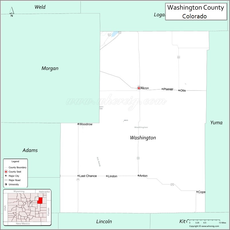
About Washington County Map, Colorado: The map showing the county boundary, county seat, major cities, highways, water bodies and neighbouring counties.
Most Viewed Links
Map of Washington County, Colorado
Washington County is a county located in the U.S. state of Colorado. It's county seat is Akron. As per 2020 census, the population of Washington County is 4861 people and population density is square miles. According to the United States Census Bureau, the county has a total area of 2,522.90 sq mi (6,534 km2). Washington County was established on -4707.
Washington County Facts
| Continent | North America |
| Country | United States |
| State | Colorado |
| County Seat | Akron |
| Largest City/Town | Akron |
| Established | 1887 |
| Total Area | 2,524 sq mi (6,538 sq km) |
| Land Area | 2,518 sq mi (6,522 sq km) |
| Water Area | 6 sq mi (16 sq km) |
| Population | 4,790 (Census 2020) |
| Population Density | 1.9 people per sq mi |
| Time Zone | Mountain Time Zone (MST/MDT) |
| Major Highways | Interstate 76, US Highway 34, US Highway 36, State Highway 71 |
| Major Rivers | Republican River watershed, Arikaree River |
| Neighboring Counties | Morgan County, Logan County, Yuma County, Kit Carson County, Lincoln County |
| Famous For | High Plains agriculture, prairie landscapes, Akron, and eastern Colorado ranching communities |
| Top Attractions | Old Town Museum, Washington County Fairgrounds, prairie wildlife areas, historic rail heritage |
| Official Website | Official Website |
About Washington County, Colorado
Washington County is located in northeastern Colorado in the United States and was established in 1887. The county seat and largest town is Akron. The county is known for agriculture, ranching, open prairie landscapes, small High Plains communities, and eastern Colorado transportation history.
Cities and Towns in Washington County, Colorado
| City/Town | Population (Census 2020) | Latitude & Longitude |
|---|---|---|
| Akron (county seat) | 1,757 | 40.1600°N, 103.2142°W |
| Otis | 475 | 40.1467°N, 102.9628°W |
| Woodrow | Historic community | 40.4008°N, 103.5017°W |
| Cope | Rural town | 39.6581°N, 102.8733°W |
| Lindon | Small farming community | 39.7033°N, 103.3706°W |
| Last Chance | Historic prairie settlement | 39.7394°N, 103.5942°W |
| Prairie grassland region | Rural landscape area | 40.0000°N, 103.2000°W |
| Republican River watershed | Agricultural region | 40.0500°N, 103.0000°W |
Golf Courses in Washington County, Colorado
| Golf Course | Location | Latitude & Longitude |
|---|---|---|
| Akron Municipal Golf Course | Akron | 40.1597°N, 103.2125°W |
| Riverview Golf Club | Sterling nearby | 40.6297°N, 103.2153°W |
| Fort Morgan Municipal Golf Course | Fort Morgan nearby | 40.2506°N, 103.7844°W |
Roads and Highways in Washington County, Colorado
Major highways connect the county to northeastern Colorado, Denver, and regional farming communities.
- Interstate 76 - major interstate linking the county with Denver and Nebraska
- US Highway 34 - east-west route connecting Akron with northeastern Colorado communities
- US Highway 36 - regional highway serving eastern Colorado prairie towns
- Colorado State Highway 71 - north-south highway crossing rural High Plains areas
Neighboring Counties of Washington County
- Morgan County (west)
- Logan County (northwest)
- Yuma County (east)
- Kit Carson County (south)
- Lincoln County (southwest)
Top Attractions in Washington County, Colorado
The county offers a mix of prairie scenery, agricultural heritage, and historical attractions.
- Old Town Museum in Akron - local history museum with pioneer and railroad exhibits
- Washington County Fairgrounds - rodeos, fairs, and agricultural community events
- Prairie wildlife viewing areas - birdwatching and High Plains wildlife habitat
- Historic railroad heritage sites - reminders of eastern Colorado transportation history
- Akron historic downtown district - local businesses and historic prairie-town architecture
- Republican River watershed landscapes - scenic agricultural and prairie environments
- Eastern Colorado scenic drives - open grasslands and rural High Plains views
- Small-town community festivals and fairs - local cultural and ranching traditions
- Prairie stargazing locations - dark sky viewing opportunities across open landscapes
- Historic homestead and farming areas - agricultural heritage attractions
- Ranchland and grassland photography spots - scenic prairie vistas and sunsets
- Regional hunting and outdoor recreation areas - seasonal wildlife and outdoor sports opportunities
Distance from Washington County to Nearby Cities
The following distances are measured by road (driving).
- Akron to Sterling (Logan County), Colorado - 55 mi (89 km)
- Akron to Fort Morgan (Morgan County), Colorado - 53 mi (85 km)
- Akron to Yuma (Yuma County), Colorado - 54 mi (87 km)
- Akron to Denver (Denver County), Colorado - 116 mi (187 km)
- Akron to Fort Collins (Larimer County), Colorado - 118 mi (190 km)
- Akron to Colorado Springs (El Paso County), Colorado - 187 mi (301 km)
- Akron to North Platte (Lincoln County), Nebraska - 178 mi (286 km)
- Akron to Cheyenne (Laramie County), Wyoming - 160 mi (257 km)
- Akron to Wichita (Sedgwick County), Kansas - 344 mi (554 km)
- Akron to Grand Junction (Mesa County), Colorado - 327 mi (526 km)
- Akron to Omaha (Douglas County), Nebraska - 366 mi (589 km)
- Akron to Amarillo (Potter County), Texas - 392 mi (631 km)
FAQs about Washington County
Washington County is located in northeastern Colorado within the High Plains region of the United States.
The population of Washington County was 4,790 according to the Census 2020.
Washington County is known for agriculture, prairie landscapes, ranching, and small eastern Colorado communities.
The county is served by Interstate 76, US Highway 34, US Highway 36, and Colorado State Highway 71.
Popular attractions include the Old Town Museum, prairie wildlife areas, county fairs, and historic railroad heritage sites.
References
- QuickFacts - U.S. Census Bureau
- United States Census Bureau
- United States Geological Survey (USGS)
- National Geodetic Survey
- Official Website
- Adams County Map
- Alamosa County Map
- Arapahoe County Map
- Archuleta County Map
- Baca County Map
- Bent County Map
- Boulder County Map
- Broomfield County Map
- Chaffee County Map
- Cheyenne County Map
- Clear Creek County Map
- Conejos County Map
- Costilla County Map
- Crowley County Map
- Custer County Map
- Delta County Map
- Denver County Map
- Dolores County Map
- Douglas County Map
- Eagle County Map
- Elbert County Map
- El Paso County Map
- Fremont County Map
- Garfield County Map
- Gilpin County Map
- Grand County Map
- Gunnison County Map
- Hinsdale County Map
- Huerfano County Map
- Jackson County Map
- Jefferson County Map
- Kiowa County Map
- Kit Carson County Map
- Lake County Map
- La Plata County Map
- Larimer County Map
- Las Animas County Map
- Lincoln County Map
- Logan County Map
- Mesa County Map
- Mineral County Map
- Moffat County Map
- Montezuma County Map
- Montrose County Map
- Morgan County Map
- Otero County Map
- Ouray County Map
- Park County Map
- Phillips County Map
- Pitkin County Map
- Prowers County Map
- Pueblo County Map
- Rio Blanco County Map
- Rio Grande County Map
- Routt County Map
- Saguache County Map
- San Juan County Map
- San Miguel County Map
- Sedgwick County Map
- Summit County Map
- Teller County Map
- Washington County Map
- Weld County Map
- Yuma County Map
- Alabama Counties
- Alaska boroughs
- Arizona Counties
- Arkansas Counties
- California County Map
- Colorado Counties
- Connecticut Counties
- Delaware Counties
- Florida County Map
- Georgia County Map
- Hawaii Counties
- Idaho Counties
- Illinois Counties
- Indiana Counties
- Iowa Counties
- Kansas Counties
- Kentucky Counties
- Louisiana Counties
- Maine Counties
- Maryland Counties
- Massachusetts Counties
- Michigan County Map
- Minnesota Counties
- Mississippi Counties
- Missouri Counties
- Montana Counties
- Nebraska Counties
- Nevada Counties
- New York Counties
- New Hampshire Counties
- New Jersey Counties
- New Mexico Counties
- North Carolina Counties
- North Dakota Counties
- Ohio County Map
- Oklahoma Counties
- Oregon Counties
- Pennsylvania Counties
- Rhode Island Counties
- South Carolina Counties
- South Dakota Counties
- Map of Tennessee
- Texas County Map
- Utah Counties
- Vermont Counties
- Virginia Counties
- Washington Counties
- West Virginia Counties
- Wisconsin Counties
- Wyoming Counties