Map of San Miguel County - San Miguel County is a county located in the U.S. state of Colorado. San Miguel County Map showing cities, highways, important places and water bodies. Get Where is San Miguel County located in the map, major cities in San Miguel county, population, areas, and places of interest.
Map of San Miguel County, Colorado
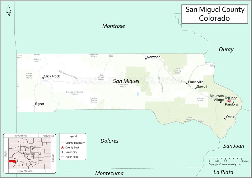
About San Miguel County Map, Colorado: The map showing the county boundary, county seat, major cities, highways, water bodies and neighbouring counties.
Most Viewed Links
Map of San Miguel County, Colorado
San Miguel County is a county located in the U.S. state of Colorado. It's county seat is Telluride. As per 2020 census, the population of San Miguel County is 8074 people and population density is square miles. According to the United States Census Bureau, the county has a total area of 1,290.76 sq mi (3,343 km2). San Miguel County was established on -6147.
San Miguel County Facts
| Continent | North America |
| Country | United States |
| State | Colorado |
| County Seat | Telluride |
| Largest City/Town | Telluride |
| Established | 1883 |
| Total Area | 1,289 sq mi (3,339 sq km) |
| Land Area | 1,287 sq mi (3,334 sq km) |
| Water Area | 2 sq mi (5 sq km) |
| Population | 8,072 (Census 2020) |
| Population Density | 6.3 people per sq mi |
| Time Zone | Mountain Time Zone (MST/MDT) |
| Major Highways | State Highway 145, State Highway 62 |
| Major Rivers | San Miguel River, Dolores River |
| Neighboring Counties | Montrose County, Ouray County, San Juan County, Dolores County, Mesa County |
| Famous For | Telluride Ski Resort, mountain festivals, alpine scenery, and mining history |
| Top Attractions | Telluride Ski Resort, Bridal Veil Falls, Telluride Historic District, Lizard Head Pass |
| Official Website | Official Website |
About San Miguel County, Colorado
San Miguel County is located in southwestern Colorado in the United States and was established in 1883. The county seat and largest town is Telluride. The county is known for dramatic mountain scenery, skiing, historic mining communities, outdoor recreation, and internationally recognized cultural festivals.
Cities and Communities in San Miguel County, Colorado
| City/Town | Population (Census 2020) | Latitude & Longitude |
|---|---|---|
| Telluride (county seat) | 2,511 | 37.9375°N, 107.8123°W |
| Mountain Village | 1,425 | 37.9319°N, 107.8562°W |
| Norwood | 1,451 | 38.1300°N, 108.2928°W |
| Ophir | 159 | 37.8569°N, 107.8289°W |
| Sawpit | 40 | 38.0006°N, 108.0592°W |
| Placerville | Historic community | 38.0222°N, 108.0522°W |
| Redvale area | Rural community | 38.2069°N, 108.4153°W |
| Lizard Head Pass region | Mountain recreation area | 37.8086°N, 107.9128°W |
Golf Courses in San Miguel County, Colorado
| Golf Course | Location | Latitude & Longitude |
|---|---|---|
| Telluride Golf Club | Mountain Village | 37.9361°N, 107.8481°W |
| Divide Ranch & Club | Ridgway nearby | 38.1517°N, 107.7581°W |
| Cobble Creek Golf Community | Montrose nearby | 38.4403°N, 107.8597°W |
Roads and Highways in San Miguel County, Colorado
Major highways connect the county to mountain recreation areas and southwestern Colorado communities.
- Colorado State Highway 145 - scenic highway linking Telluride with Cortez, Dolores, and Montrose regions
- Colorado State Highway 62 - route connecting Placerville with Ridgway and western mountain communities
Neighboring Counties of San Miguel County
- Montrose County (north)
- Ouray County (east)
- San Juan County (southeast)
- Dolores County (southwest)
- Mesa County (northwest)
Top Attractions in San Miguel County, Colorado
The county offers a mix of ski tourism, alpine scenery, and outdoor recreation attractions.
- Telluride Ski Resort - internationally known ski and snowboard destination
- Bridal Veil Falls - Colorado’s tallest free-falling waterfall located near Telluride
- Telluride Historic District - preserved mining-era downtown with shops, restaurants, and cultural sites
- Mountain Village Gondola - scenic free gondola transportation system between Telluride and Mountain Village
- Lizard Head Pass - scenic mountain pass known for hiking and alpine views
- Telluride Bluegrass Festival - famous annual music festival attracting international visitors
- Bear Creek Falls Trail - popular hiking route near Telluride
- San Miguel River recreation areas - fishing, rafting, and outdoor activities
- Alta Lakes - alpine lakes recreation area for camping and hiking
- Ophir Pass jeep trails - off-road recreation and scenic mountain exploration
- Uncompahgre National Forest recreation areas - hiking, camping, and wildlife viewing
- Historic mining ruins and ghost towns - preserved remnants of Colorado mining history
Distance from San Miguel County to Nearby Cities
The following distances are measured by road (driving).
- Telluride to Ouray (Ouray County), Colorado - 50 mi (80 km)
- Telluride to Montrose (Montrose County), Colorado - 67 mi (108 km)
- Telluride to Silverton (San Juan County), Colorado - 73 mi (117 km)
- Telluride to Cortez (Montezuma County), Colorado - 91 mi (146 km)
- Telluride to Durango (La Plata County), Colorado - 112 mi (180 km)
- Telluride to Grand Junction (Mesa County), Colorado - 129 mi (208 km)
- Telluride to Moab (Grand County), Utah - 138 mi (222 km)
- Telluride to Aspen (Pitkin County), Colorado - 170 mi (274 km)
- Telluride to Salt Lake City (Salt Lake County), Utah - 370 mi (595 km)
- Telluride to Denver (Denver County), Colorado - 330 mi (531 km)
- Telluride to Colorado Springs (El Paso County), Colorado - 381 mi (613 km)
- Telluride to Santa Fe (Santa Fe County), New Mexico - 315 mi (507 km)
FAQs about San Miguel County
San Miguel County is located in southwestern Colorado within the San Juan Mountains region of the United States.
The population of San Miguel County was 8,072 according to the Census 2020.
San Miguel County is known for Telluride Ski Resort, mountain festivals, alpine scenery, and mining history.
The county is served by Colorado State Highway 145 and Colorado State Highway 62.
Popular attractions include Telluride Ski Resort, Bridal Veil Falls, the Telluride Historic District, and Lizard Head Pass.
References
- QuickFacts - U.S. Census Bureau
- United States Census Bureau
- United States Geological Survey (USGS)
- National Geodetic Survey
- Official Website
- Adams County Map
- Alamosa County Map
- Arapahoe County Map
- Archuleta County Map
- Baca County Map
- Bent County Map
- Boulder County Map
- Broomfield County Map
- Chaffee County Map
- Cheyenne County Map
- Clear Creek County Map
- Conejos County Map
- Costilla County Map
- Crowley County Map
- Custer County Map
- Delta County Map
- Denver County Map
- Dolores County Map
- Douglas County Map
- Eagle County Map
- Elbert County Map
- El Paso County Map
- Fremont County Map
- Garfield County Map
- Gilpin County Map
- Grand County Map
- Gunnison County Map
- Hinsdale County Map
- Huerfano County Map
- Jackson County Map
- Jefferson County Map
- Kiowa County Map
- Kit Carson County Map
- Lake County Map
- La Plata County Map
- Larimer County Map
- Las Animas County Map
- Lincoln County Map
- Logan County Map
- Mesa County Map
- Mineral County Map
- Moffat County Map
- Montezuma County Map
- Montrose County Map
- Morgan County Map
- Otero County Map
- Ouray County Map
- Park County Map
- Phillips County Map
- Pitkin County Map
- Prowers County Map
- Pueblo County Map
- Rio Blanco County Map
- Rio Grande County Map
- Routt County Map
- Saguache County Map
- San Juan County Map
- San Miguel County Map
- Sedgwick County Map
- Summit County Map
- Teller County Map
- Washington County Map
- Weld County Map
- Yuma County Map
- Alabama Counties
- Alaska boroughs
- Arizona Counties
- Arkansas Counties
- California County Map
- Colorado Counties
- Connecticut Counties
- Delaware Counties
- Florida County Map
- Georgia County Map
- Hawaii Counties
- Idaho Counties
- Illinois Counties
- Indiana Counties
- Iowa Counties
- Kansas Counties
- Kentucky Counties
- Louisiana Counties
- Maine Counties
- Maryland Counties
- Massachusetts Counties
- Michigan County Map
- Minnesota Counties
- Mississippi Counties
- Missouri Counties
- Montana Counties
- Nebraska Counties
- Nevada Counties
- New York Counties
- New Hampshire Counties
- New Jersey Counties
- New Mexico Counties
- North Carolina Counties
- North Dakota Counties
- Ohio County Map
- Oklahoma Counties
- Oregon Counties
- Pennsylvania Counties
- Rhode Island Counties
- South Carolina Counties
- South Dakota Counties
- Map of Tennessee
- Texas County Map
- Utah Counties
- Vermont Counties
- Virginia Counties
- Washington Counties
- West Virginia Counties
- Wisconsin Counties
- Wyoming Counties