Map of Custer County - Custer County is a county located in the U.S. state of Colorado. Custer County Map showing cities, highways, important places and water bodies. Get Where is Custer County located in the map, major cities in Custer county, population, areas, and places of interest.
Map of Custer County, Colorado
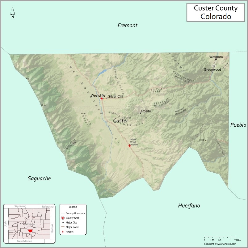
About Custer County Map, Colorado: The map showing the county boundary, county seat, major cities, highways, water bodies and neighbouring counties.
Most Viewed Links
Map of Custer County, Colorado
Custer County is a county located in the U.S. state of Colorado. It's county seat is Westcliffe. As per 2020 census, the population of Custer County is 5045 people and population density is square miles. According to the United States Census Bureau, the county has a total area of 739.24 sq mi (1,915 km2). Custer County was established on -8331.
Custer County Facts
| Continent | North America |
| Country | United States |
| State | Colorado |
| County Seat | Westcliffe |
| Largest City/Town | Westcliffe |
| Established | 1877 |
| Total Area | 740 sq mi (1,917 sq km) |
| Land Area | 737 sq mi (1,909 sq km) |
| Water Area | 3 sq mi (8 sq km) |
| Population | 4,981 (Census 2020) |
| Population Density | 6.8 people per sq mi |
| Time Zone | Mountain Time Zone (MST/MDT) |
| Major Highways | State Highway 69, State Highway 96 |
| Major Rivers | Arkansas River watershed, Grape Creek |
| Neighboring Counties | Fremont County, Huerfano County, Pueblo County, Saguache County |
| Famous For | Wet Mountain Valley, Sangre de Cristo Mountains, dark sky viewing, and outdoor recreation |
| Top Attractions | Great Sand Dunes nearby, Bishop Castle, Sangre de Cristo Wilderness, Westcliffe observatories |
| Official Website | Official Website |
About Custer County, Colorado
Custer County is located in south-central Colorado in the United States and was established in 1877. The county seat and largest town is Westcliffe. The county is known for scenic mountain valleys, ranching communities, dark night skies, hiking trails, and outdoor recreation near the Sangre de Cristo Mountains.
Cities and Towns in Custer County, Colorado
| City/Town | Population (Census 2020) | Latitude & Longitude |
|---|---|---|
| Westcliffe (county seat) | 568 | 38.1347°N, 105.4650°W |
| Silver Cliff | 587 | 38.1358°N, 105.4422°W |
| Rosita (CDP) | 89 | 38.1083°N, 105.3333°W |
| Wetmore (CDP) | 71 | 38.2378°N, 105.0831°W |
Golf Courses in Custer County, Colorado
| Golf Course | Location | Latitude & Longitude |
|---|---|---|
| Hollydot Golf Course | Colorado City | 37.9506°N, 104.8344°W |
| Wet Mountain Valley Recreation Golf Area | Westcliffe | 38.1372°N, 105.4656°W |
Roads and Highways in Custer County, Colorado
Major highways connect the county to mountain valleys and nearby southern Colorado communities.
- Colorado State Highway 69 - north-south highway connecting Westcliffe with Canon City and Walsenburg
- Colorado State Highway 96 - east-west route connecting Wetmore with Pueblo County and mountain areas
Neighboring Counties of Custer County
- Fremont County (north)
- Pueblo County (east)
- Huerfano County (south)
- Saguache County (west)
Top Attractions in Custer County, Colorado
The county offers a mix of natural and historical attractions.
- Sangre de Cristo Wilderness - wilderness area featuring mountain peaks, alpine lakes, and hiking trails
- Westcliffe Dark Sky Community - internationally recognized destination for astronomy and stargazing
- Bishop Castle - unique hand-built stone castle and roadside attraction near Wetmore
- Wet Mountain Valley - scenic valley surrounded by mountain ranges and ranchlands
- Silver Cliff Museum - local museum highlighting mining and pioneer history
- Lake DeWeese Reservoir - recreation area popular for fishing, boating, and camping
- Rainbow Trail - long-distance hiking trail along the Sangre de Cristo Mountains
- Hermit Pass - scenic mountain route with hiking and wildlife viewing opportunities
- San Isabel National Forest - forest recreation area with camping and scenic drives
- Westcliffe Observatory - astronomy center offering educational programs and sky viewing events
- Blanca Peak Scenic Views - panoramic mountain scenery visible from the valley region
- Historic Rosita Mining District - former mining settlement with historic sites and mountain scenery
Distance from Custer County to Nearby Cities
The following distances are measured by road (driving).
- Westcliffe to Canon City (Fremont County), Colorado - 52 mi (84 km)
- Westcliffe to Pueblo (Pueblo County), Colorado - 67 mi (108 km)
- Westcliffe to Walsenburg (Huerfano County), Colorado - 57 mi (92 km)
- Westcliffe to Salida (Chaffee County), Colorado - 73 mi (117 km)
- Westcliffe to Colorado Springs (El Paso County), Colorado - 82 mi (132 km)
- Westcliffe to Alamosa (Alamosa County), Colorado - 118 mi (190 km)
- Westcliffe to Denver (Denver County), Colorado - 170 mi (274 km)
- Westcliffe to Trinidad (Las Animas County), Colorado - 118 mi (190 km)
- Westcliffe to Gunnison (Gunnison County), Colorado - 146 mi (235 km)
- Westcliffe to Leadville (Lake County), Colorado - 117 mi (188 km)
- Westcliffe to Breckenridge (Summit County), Colorado - 136 mi (219 km)
- Westcliffe to Taos (Taos County), New Mexico - 183 mi (295 km)
FAQs about Custer County
Custer County is located in south-central Colorado within the Wet Mountain Valley region of the United States.
The population of Custer County was 4,981 according to the Census 2020.
Custer County is known for mountain scenery, dark sky stargazing, outdoor recreation, and the Sangre de Cristo Mountains.
The county is served by Colorado State Highway 69 and Colorado State Highway 96.
Custer County has nearby regional golf facilities and recreation golf areas serving the Wet Mountain Valley communities.
References
- QuickFacts - U.S. Census Bureau
- United States Census Bureau
- United States Geological Survey (USGS)
- National Geodetic Survey
- Official Website
- Adams County Map
- Alamosa County Map
- Arapahoe County Map
- Archuleta County Map
- Baca County Map
- Bent County Map
- Boulder County Map
- Broomfield County Map
- Chaffee County Map
- Cheyenne County Map
- Clear Creek County Map
- Conejos County Map
- Costilla County Map
- Crowley County Map
- Custer County Map
- Delta County Map
- Denver County Map
- Dolores County Map
- Douglas County Map
- Eagle County Map
- Elbert County Map
- El Paso County Map
- Fremont County Map
- Garfield County Map
- Gilpin County Map
- Grand County Map
- Gunnison County Map
- Hinsdale County Map
- Huerfano County Map
- Jackson County Map
- Jefferson County Map
- Kiowa County Map
- Kit Carson County Map
- Lake County Map
- La Plata County Map
- Larimer County Map
- Las Animas County Map
- Lincoln County Map
- Logan County Map
- Mesa County Map
- Mineral County Map
- Moffat County Map
- Montezuma County Map
- Montrose County Map
- Morgan County Map
- Otero County Map
- Ouray County Map
- Park County Map
- Phillips County Map
- Pitkin County Map
- Prowers County Map
- Pueblo County Map
- Rio Blanco County Map
- Rio Grande County Map
- Routt County Map
- Saguache County Map
- San Juan County Map
- San Miguel County Map
- Sedgwick County Map
- Summit County Map
- Teller County Map
- Washington County Map
- Weld County Map
- Yuma County Map
- Alabama Counties
- Alaska boroughs
- Arizona Counties
- Arkansas Counties
- California County Map
- Colorado Counties
- Connecticut Counties
- Delaware Counties
- Florida County Map
- Georgia County Map
- Hawaii Counties
- Idaho Counties
- Illinois Counties
- Indiana Counties
- Iowa Counties
- Kansas Counties
- Kentucky Counties
- Louisiana Counties
- Maine Counties
- Maryland Counties
- Massachusetts Counties
- Michigan County Map
- Minnesota Counties
- Mississippi Counties
- Missouri Counties
- Montana Counties
- Nebraska Counties
- Nevada Counties
- New York Counties
- New Hampshire Counties
- New Jersey Counties
- New Mexico Counties
- North Carolina Counties
- North Dakota Counties
- Ohio County Map
- Oklahoma Counties
- Oregon Counties
- Pennsylvania Counties
- Rhode Island Counties
- South Carolina Counties
- South Dakota Counties
- Map of Tennessee
- Texas County Map
- Utah Counties
- Vermont Counties
- Virginia Counties
- Washington Counties
- West Virginia Counties
- Wisconsin Counties
- Wyoming Counties