Map of Teller County - Teller County is a county located in the U.S. state of Colorado. Teller County Map showing cities, highways, important places and water bodies. Get Where is Teller County located in the map, major cities in Teller county, population, areas, and places of interest.
Map of Teller County, Colorado
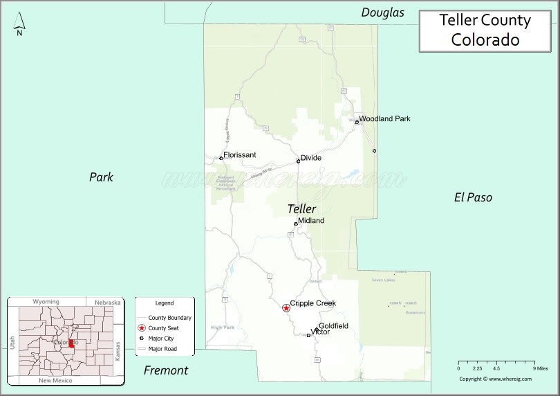
About Teller County Map, Colorado: The map showing the county boundary, county seat, major cities, highways, water bodies and neighbouring counties.
Most Viewed Links
Map of Teller County, Colorado
Teller County is a county located in the U.S. state of Colorado. It's county seat is Cripple Creek. As per 2020 census, the population of Teller County is 24926 people and population density is square miles. According to the United States Census Bureau, the county has a total area of 558.58 sq mi (1,447 km2). Teller County was established on -282.
Teller County Facts
| Continent | North America |
| Country | United States |
| State | Colorado |
| County Seat | Cripple Creek |
| Largest City/Town | Woodland Park |
| Established | 1899 |
| Total Area | 559 sq mi (1,448 sq km) |
| Land Area | 557 sq mi (1,443 sq km) |
| Water Area | 2 sq mi (5 sq km) |
| Population | 24,710 (Census 2020) |
| Population Density | 44.4 people per sq mi |
| Time Zone | Mountain Time Zone (MST/MDT) |
| Major Highways | US Highway 24, State Highway 67 |
| Major Rivers | South Platte River watershed, Fourmile Creek |
| Neighboring Counties | El Paso County, Park County, Fremont County, Douglas County, Jefferson County |
| Famous For | Cripple Creek gold mining history, mountain scenery, casinos, and outdoor recreation |
| Top Attractions | Cripple Creek casinos, Pikes Peak region, Mollie Kathleen Gold Mine, Mueller State Park |
| Official Website | Official Website |
About Teller County, Colorado
Teller County is located in central Colorado in the United States and was established in 1899. The county seat is Cripple Creek, while Woodland Park is the largest city. The county is known for historic gold mining towns, casino tourism, mountain recreation, forests, and scenic landscapes near Pikes Peak.
Cities and Towns in Teller County, Colorado
| City/Town | Population (Census 2020) | Latitude & Longitude |
|---|---|---|
| Woodland Park | 7,920 | 38.9939°N, 105.0569°W |
| Cripple Creek (county seat) | 1,115 | 38.7469°N, 105.1786°W |
| Victor | 397 | 38.7044°N, 105.1397°W |
| Florissant | 104 | 38.9456°N, 105.2861°W |
| Divide | Regional mountain community | 38.9450°N, 105.1583°W |
| Midland | Historic area | 38.8439°N, 105.1444°W |
| Cascade-Chipita Park nearby area | Mountain recreation region | 38.8964°N, 104.9728°W |
| Pikes Peak foothills region | Scenic mountain area | 38.9000°N, 105.1000°W |
Golf Courses in Teller County, Colorado
| Golf Course | Location | Latitude & Longitude |
|---|---|---|
| Shining Mountain Golf Club | Woodland Park | 39.0017°N, 105.0714°W |
| Patty Jewett Golf Course | Colorado Springs nearby | 38.8600°N, 104.7908°W |
| Kissing Camels Golf Club | Colorado Springs nearby | 38.8733°N, 104.8714°W |
Roads and Highways in Teller County, Colorado
Major highways connect the county to Colorado Springs, mountain communities, and recreation destinations.
- US Highway 24 - major route linking Woodland Park with Colorado Springs and central Colorado
- Colorado State Highway 67 - scenic highway connecting Cripple Creek, Divide, and Sedalia regions
Neighboring Counties of Teller County
- El Paso County (east)
- Douglas County (northeast)
- Jefferson County (north)
- Park County (west)
- Fremont County (southwest)
Top Attractions in Teller County, Colorado
The county offers a mix of mining heritage, mountain recreation, and scenic attractions.
- Cripple Creek casinos - historic gaming district and entertainment destination
- Mollie Kathleen Gold Mine - underground mine tours exploring Colorado gold mining history
- Mueller State Park - hiking, camping, wildlife viewing, and mountain scenery
- Florissant Fossil Beds National Monument - fossil displays and geological attractions
- Pikes Peak region recreation areas - hiking, scenic drives, and outdoor activities
- Cripple Creek & Victor Narrow Gauge Railroad - historic train rides through mining country
- Historic Downtown Cripple Creek - preserved Victorian buildings, museums, and casinos
- Victor Historic District - former mining town with preserved heritage architecture
- Rampart Reservoir nearby - fishing, boating, and camping destination
- American Eagles Overlook and Historic Mine Park - mining history exhibits and scenic views
- Woodland Park hiking and recreation trails - outdoor activities in the Pike National Forest
- Gold Camp Road scenic route - mountain drive with tunnels and historic railroad grades
Distance from Teller County to Nearby Cities
The following distances are measured by road (driving).
- Woodland Park to Colorado Springs (El Paso County), Colorado - 19 mi (31 km)
- Woodland Park to Cripple Creek (Teller County), Colorado - 24 mi (39 km)
- Woodland Park to Canon City (Fremont County), Colorado - 53 mi (85 km)
- Woodland Park to Denver (Denver County), Colorado - 88 mi (142 km)
- Woodland Park to Pueblo (Pueblo County), Colorado - 72 mi (116 km)
- Woodland Park to Breckenridge (Summit County), Colorado - 108 mi (174 km)
- Woodland Park to Salida (Chaffee County), Colorado - 79 mi (127 km)
- Woodland Park to Aspen (Pitkin County), Colorado - 181 mi (291 km)
- Woodland Park to Grand Junction (Mesa County), Colorado - 252 mi (406 km)
- Woodland Park to Santa Fe (Santa Fe County), New Mexico - 290 mi (467 km)
- Woodland Park to Albuquerque (Bernalillo County), New Mexico - 354 mi (570 km)
- Woodland Park to Cheyenne (Laramie County), Wyoming - 204 mi (328 km)
FAQs about Teller County
Teller County is located in central Colorado near the Pikes Peak region in the United States.
The population of Teller County was 24,710 according to the Census 2020.
Teller County is known for Cripple Creek gold mining history, casinos, mountain recreation, and scenic forests.
The county is served by US Highway 24 and Colorado State Highway 67.
Popular attractions include Cripple Creek casinos, Mueller State Park, the Mollie Kathleen Gold Mine, and Florissant Fossil Beds National Monument.
References
- QuickFacts - U.S. Census Bureau
- United States Census Bureau
- United States Geological Survey (USGS)
- National Geodetic Survey
- Official Website
- Adams County Map
- Alamosa County Map
- Arapahoe County Map
- Archuleta County Map
- Baca County Map
- Bent County Map
- Boulder County Map
- Broomfield County Map
- Chaffee County Map
- Cheyenne County Map
- Clear Creek County Map
- Conejos County Map
- Costilla County Map
- Crowley County Map
- Custer County Map
- Delta County Map
- Denver County Map
- Dolores County Map
- Douglas County Map
- Eagle County Map
- Elbert County Map
- El Paso County Map
- Fremont County Map
- Garfield County Map
- Gilpin County Map
- Grand County Map
- Gunnison County Map
- Hinsdale County Map
- Huerfano County Map
- Jackson County Map
- Jefferson County Map
- Kiowa County Map
- Kit Carson County Map
- Lake County Map
- La Plata County Map
- Larimer County Map
- Las Animas County Map
- Lincoln County Map
- Logan County Map
- Mesa County Map
- Mineral County Map
- Moffat County Map
- Montezuma County Map
- Montrose County Map
- Morgan County Map
- Otero County Map
- Ouray County Map
- Park County Map
- Phillips County Map
- Pitkin County Map
- Prowers County Map
- Pueblo County Map
- Rio Blanco County Map
- Rio Grande County Map
- Routt County Map
- Saguache County Map
- San Juan County Map
- San Miguel County Map
- Sedgwick County Map
- Summit County Map
- Teller County Map
- Washington County Map
- Weld County Map
- Yuma County Map
- Alabama Counties
- Alaska boroughs
- Arizona Counties
- Arkansas Counties
- California County Map
- Colorado Counties
- Connecticut Counties
- Delaware Counties
- Florida County Map
- Georgia County Map
- Hawaii Counties
- Idaho Counties
- Illinois Counties
- Indiana Counties
- Iowa Counties
- Kansas Counties
- Kentucky Counties
- Louisiana Counties
- Maine Counties
- Maryland Counties
- Massachusetts Counties
- Michigan County Map
- Minnesota Counties
- Mississippi Counties
- Missouri Counties
- Montana Counties
- Nebraska Counties
- Nevada Counties
- New York Counties
- New Hampshire Counties
- New Jersey Counties
- New Mexico Counties
- North Carolina Counties
- North Dakota Counties
- Ohio County Map
- Oklahoma Counties
- Oregon Counties
- Pennsylvania Counties
- Rhode Island Counties
- South Carolina Counties
- South Dakota Counties
- Map of Tennessee
- Texas County Map
- Utah Counties
- Vermont Counties
- Virginia Counties
- Washington Counties
- West Virginia Counties
- Wisconsin Counties
- Wyoming Counties