Map of Yuma County - Yuma County is a county located in the U.S. state of Colorado. Yuma County Map showing cities, highways, important places and water bodies. Get Where is Yuma County located in the map, major cities in Yuma county, population, areas, and places of interest.
Map of Yuma County, Colorado
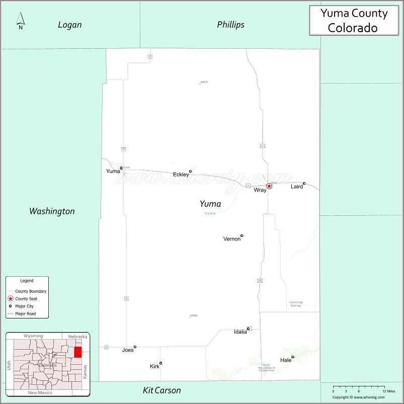
About Yuma County Map, Colorado: The map showing the county boundary, county seat, major cities, highways, water bodies and neighbouring counties.
Most Viewed Links
Map of Yuma County, Colorado
Yuma County is a county located in the U.S. state of Colorado. It's county seat is Wray. As per 2020 census, the population of Yuma County is 9941 people and population density is square miles. According to the United States Census Bureau, the county has a total area of 2,369.61 sq mi (6,137 km2). Yuma County was established on -3942.
Yuma County Facts
| Continent | North America |
| Country | United States |
| State | Colorado |
| County Seat | Wray |
| Largest City/Town | Wray |
| Established | 1889 |
| Total Area | 2,369 sq mi (6,136 sq km) |
| Land Area | 2,364 sq mi (6,123 sq km) |
| Water Area | 5 sq mi (13 sq km) |
| Population | 9,816 (Census 2020) |
| Population Density | 4.2 people per sq mi |
| Time Zone | Mountain Time Zone (MST/MDT) |
| Major Highways | US Highway 34, US Highway 36, US Highway 385, State Highway 59 |
| Major Rivers | Republican River, Arikaree River |
| Neighboring Counties | Washington County, Kit Carson County, Phillips County, Dundy County (NE), Cheyenne County (KS) |
| Famous For | High Plains agriculture, cattle ranching, prairie landscapes, and eastern Colorado communities |
| Top Attractions | Bonny Lake region, Yuma Museum, Wray Fish Hatchery, prairie wildlife areas |
| Official Website | Official Website |
About Yuma County, Colorado
Yuma County is located in northeastern Colorado in the United States and was established in 1889. The county seat and largest city is Wray. The county is known for farming, ranching, open prairie landscapes, small High Plains communities, and outdoor recreation opportunities in eastern Colorado.
Cities and Towns in Yuma County, Colorado
| City/Town | Population (Census 2020) | Latitude & Longitude |
|---|---|---|
| Wray (county seat) | 2,358 | 40.0750°N, 102.2238°W |
| Yuma | 3,456 | 40.1217°N, 102.7244°W |
| Eckley | 232 | 40.1125°N, 102.4878°W |
| Idalia | 97 | 39.7022°N, 102.2939°W |
| Kirk | Historic community | 39.6397°N, 102.5961°W |
| Beecher Island region | Historic prairie area | 39.7800°N, 102.1600°W |
| Bonny Reservoir region | Outdoor recreation area | 39.6200°N, 102.1800°W |
| Republican River Valley | Agricultural landscape area | 40.0000°N, 102.4000°W |
Golf Courses in Yuma County, Colorado
| Golf Course | Location | Latitude & Longitude |
|---|---|---|
| Indian Hills Golf Club | Yuma | 40.1244°N, 102.7211°W |
| Wray Golf Course | Wray | 40.0756°N, 102.2261°W |
| Holyoke Country Club | Holyoke nearby | 40.5825°N, 102.3036°W |
Roads and Highways in Yuma County, Colorado
Major highways connect the county to northeastern Colorado, Nebraska, Kansas, and regional prairie communities.
- US Highway 34 - east-west route connecting Yuma County with northeastern Colorado communities
- US Highway 36 - regional highway serving eastern Colorado and western Kansas
- US Highway 385 - north-south route linking Colorado with Nebraska and the Texas Panhandle
- Colorado State Highway 59 - rural highway connecting farming and ranching communities
Neighboring Counties of Yuma County
- Washington County (west)
- Phillips County (northwest)
- Kit Carson County (south)
- Dundy County, Nebraska (north)
- Cheyenne County, Kansas (east)
Top Attractions in Yuma County, Colorado
The county offers a mix of prairie recreation, local history, and agricultural heritage attractions.
- Bonny Lake region - boating, fishing, camping, and prairie recreation destination
- Yuma Museum - exhibits on county history, agriculture, and pioneer settlement
- Wray Fish Hatchery - outdoor recreation and wildlife attraction
- Beecher Island Battlefield historic site - important frontier-era historical landmark
- Republican River recreation areas - fishing, birdwatching, and nature activities
- Prairie wildlife viewing regions - migratory birds and High Plains wildlife habitat
- Historic downtown Wray - local businesses and small-town Colorado culture
- Eastern Colorado scenic drives - open grassland and agricultural landscapes
- County fairs and rodeos - celebrations of ranching and farming traditions
- Dark sky viewing areas - stargazing opportunities across rural prairie landscapes
- Historic homestead and railroad heritage locations - reminders of settlement history
- Prairie photography and sunset viewing spots - scenic High Plains environments
Distance from Yuma County to Nearby Cities
The following distances are measured by road (driving).
- Wray to Yuma (Yuma County), Colorado - 33 mi (53 km)
- Wray to Holyoke (Phillips County), Colorado - 37 mi (60 km)
- Wray to Akron (Washington County), Colorado - 54 mi (87 km)
- Wray to Sterling (Logan County), Colorado - 102 mi (164 km)
- Wray to Denver (Denver County), Colorado - 152 mi (245 km)
- Wray to Fort Collins (Larimer County), Colorado - 181 mi (291 km)
- Wray to North Platte (Lincoln County), Nebraska - 153 mi (246 km)
- Wray to Cheyenne (Laramie County), Wyoming - 223 mi (359 km)
- Wray to Wichita (Sedgwick County), Kansas - 295 mi (475 km)
- Wray to Colorado Springs (El Paso County), Colorado - 225 mi (362 km)
- Wray to Omaha (Douglas County), Nebraska - 336 mi (541 km)
- Wray to Amarillo (Potter County), Texas - 372 mi (599 km)
FAQs about Yuma County
Yuma County is located in northeastern Colorado near the Nebraska and Kansas borders in the United States.
The population of Yuma County was 9,816 according to the Census 2020.
Yuma County is known for agriculture, ranching, prairie landscapes, and eastern Colorado High Plains communities.
The county is served by US Highway 34, US Highway 36, US Highway 385, and Colorado State Highway 59.
Popular attractions include the Bonny Lake region, Beecher Island historic site, Yuma Museum, and prairie wildlife areas.
References
- QuickFacts - U.S. Census Bureau
- United States Census Bureau
- United States Geological Survey (USGS)
- National Geodetic Survey
- Official Website
- Adams County Map
- Alamosa County Map
- Arapahoe County Map
- Archuleta County Map
- Baca County Map
- Bent County Map
- Boulder County Map
- Broomfield County Map
- Chaffee County Map
- Cheyenne County Map
- Clear Creek County Map
- Conejos County Map
- Costilla County Map
- Crowley County Map
- Custer County Map
- Delta County Map
- Denver County Map
- Dolores County Map
- Douglas County Map
- Eagle County Map
- Elbert County Map
- El Paso County Map
- Fremont County Map
- Garfield County Map
- Gilpin County Map
- Grand County Map
- Gunnison County Map
- Hinsdale County Map
- Huerfano County Map
- Jackson County Map
- Jefferson County Map
- Kiowa County Map
- Kit Carson County Map
- Lake County Map
- La Plata County Map
- Larimer County Map
- Las Animas County Map
- Lincoln County Map
- Logan County Map
- Mesa County Map
- Mineral County Map
- Moffat County Map
- Montezuma County Map
- Montrose County Map
- Morgan County Map
- Otero County Map
- Ouray County Map
- Park County Map
- Phillips County Map
- Pitkin County Map
- Prowers County Map
- Pueblo County Map
- Rio Blanco County Map
- Rio Grande County Map
- Routt County Map
- Saguache County Map
- San Juan County Map
- San Miguel County Map
- Sedgwick County Map
- Summit County Map
- Teller County Map
- Washington County Map
- Weld County Map
- Yuma County Map
- Alabama Counties
- Alaska boroughs
- Arizona Counties
- Arkansas Counties
- California County Map
- Colorado Counties
- Connecticut Counties
- Delaware Counties
- Florida County Map
- Georgia County Map
- Hawaii Counties
- Idaho Counties
- Illinois Counties
- Indiana Counties
- Iowa Counties
- Kansas Counties
- Kentucky Counties
- Louisiana Counties
- Maine Counties
- Maryland Counties
- Massachusetts Counties
- Michigan County Map
- Minnesota Counties
- Mississippi Counties
- Missouri Counties
- Montana Counties
- Nebraska Counties
- Nevada Counties
- New York Counties
- New Hampshire Counties
- New Jersey Counties
- New Mexico Counties
- North Carolina Counties
- North Dakota Counties
- Ohio County Map
- Oklahoma Counties
- Oregon Counties
- Pennsylvania Counties
- Rhode Island Counties
- South Carolina Counties
- South Dakota Counties
- Map of Tennessee
- Texas County Map
- Utah Counties
- Vermont Counties
- Virginia Counties
- Washington Counties
- West Virginia Counties
- Wisconsin Counties
- Wyoming Counties