Map of Rio Blanco County - Rio Blanco County is a county located in the U.S. state of Colorado. Rio Blanco County Map showing cities, highways, important places and water bodies. Get Where is Rio Blanco County located in the map, major cities in Rio Blanco county, population, areas, and places of interest.
Map of Rio Blanco County, Colorado
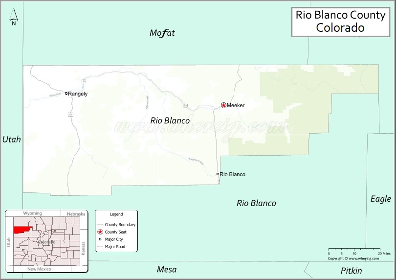
About Rio Blanco County Map, Colorado: The map showing the county boundary, county seat, major cities, highways, water bodies and neighbouring counties.
Most Viewed Links
Map of Rio Blanco County, Colorado
Rio Blanco County is a county located in the U.S. state of Colorado. It's county seat is Meeker. As per 2020 census, the population of Rio Blanco County is 6476 people and population density is square miles. According to the United States Census Bureau, the county has a total area of 3,226.24 sq mi (8,356 km2). Rio Blanco County was established on -3932.
Rio Blanco County Facts
| Continent | North America |
| Country | United States |
| State | Colorado |
| County Seat | Meeker |
| Largest City/Town | Rangely |
| Established | 1889 |
| Total Area | 3,223 sq mi (8,348 sq km) |
| Land Area | 3,221 sq mi (8,343 sq km) |
| Water Area | 2 sq mi (5 sq km) |
| Population | 6,529 (Census 2020) |
| Population Density | 2.0 people per sq mi |
| Time Zone | Mountain Time Zone (MST/MDT) |
| Major Highways | State Highway 13, State Highway 64 |
| Major Rivers | White River |
| Neighboring Counties | Moffat County, Garfield County, Mesa County, Uintah County (UT) |
| Famous For | White River Valley, ranching, energy resources, hunting, and western Colorado wilderness |
| Top Attractions | White River National Forest, Rangely Outdoor Museum, Meeker Sheepdog Trials, Flat Tops Wilderness |
| Official Website | Official Website |
About Rio Blanco County, Colorado
Rio Blanco County is located in northwestern Colorado in the United States and was established in 1889. The county seat is Meeker, while Rangely is the largest town. The county is known for ranching, oil and natural gas production, outdoor recreation, hunting, and scenic landscapes surrounding the White River Valley and Flat Tops Wilderness.
Cities and Communities in Rio Blanco County, Colorado
| City/Town | Population (Census 2020) | Latitude & Longitude |
|---|---|---|
| Rangely | 2,365 | 40.0894°N, 108.8040°W |
| Meeker (county seat) | 2,374 | 40.0375°N, 107.9131°W |
| Buford | Historic community | 40.0108°N, 107.9503°W |
| Rio Blanco community | Rural area | 39.7375°N, 108.1378°W |
| Piceance Creek area | Energy region | 39.8500°N, 108.2500°W |
| Flat Tops region | Mountain recreation area | 39.9600°N, 107.5200°W |
| Douglas Creek area | Scenic canyon region | 39.9300°N, 108.7800°W |
| White River Valley | Regional landscape area | 40.0200°N, 108.0000°W |
Golf Courses in Rio Blanco County, Colorado
| Golf Course | Location | Latitude & Longitude |
|---|---|---|
| Meeker Golf Course | Meeker | 40.0342°N, 107.9094°W |
| Cedar Ridges Golf Course | Rangely | 40.0928°N, 108.8011°W |
| Battlement Mesa Golf Club | Parachute nearby | 39.4472°N, 108.0464°W |
Roads and Highways in Rio Blanco County, Colorado
Major highways connect the county to northwestern Colorado, Utah, and mountain recreation regions.
- Colorado State Highway 13 - north-south highway linking Meeker, Rifle, Craig, and Wyoming
- Colorado State Highway 64 - east-west route connecting Rangely with Meeker and Dinosaur National Monument regions
Neighboring Counties of Rio Blanco County
- Moffat County (north)
- Garfield County (east)
- Mesa County (south)
- Uintah County, Utah (west)
Top Attractions in Rio Blanco County, Colorado
The county offers a mix of outdoor recreation, western heritage, and scenic wilderness attractions.
- Flat Tops Wilderness Area - hiking, camping, fishing, and alpine recreation destination
- White River National Forest recreation areas - mountain scenery and wildlife viewing opportunities
- Meeker Classic Sheepdog Championship Trials - internationally known sheepdog competition and festival
- Rangely Outdoor Museum - exhibits on local history, ranching, and energy development
- White River fishing and rafting areas - trout fishing and river recreation destination
- Piceance Basin scenic drives - rugged canyon landscapes and geological formations
- Douglas Creek Canyon - remote canyon scenery and wildlife habitat
- Historic Downtown Meeker - western heritage buildings, shops, and museums
- Rangely rock art and archaeology sites - petroglyph and cultural heritage attractions
- Hunting and wildlife recreation areas - elk, deer, and outdoor sports opportunities
- Harper Corner scenic region nearby - views toward Dinosaur National Monument landscapes
- High desert and mountain scenic routes - open western Colorado landscapes and recreation access
Distance from Rio Blanco County to Nearby Cities
The following distances are measured by road (driving).
- Meeker to Craig (Moffat County), Colorado - 48 mi (77 km)
- Meeker to Rifle (Garfield County), Colorado - 41 mi (66 km)
- Meeker to Rangely (Rio Blanco County), Colorado - 64 mi (103 km)
- Meeker to Grand Junction (Mesa County), Colorado - 105 mi (169 km)
- Meeker to Vernal (Uintah County), Utah - 92 mi (148 km)
- Meeker to Steamboat Springs (Routt County), Colorado - 94 mi (151 km)
- Meeker to Glenwood Springs (Garfield County), Colorado - 70 mi (113 km)
- Meeker to Aspen (Pitkin County), Colorado - 129 mi (208 km)
- Meeker to Denver (Denver County), Colorado - 236 mi (380 km)
- Meeker to Salt Lake City (Salt Lake County), Utah - 314 mi (505 km)
- Meeker to Moab (Grand County), Utah - 195 mi (314 km)
- Meeker to Colorado Springs (El Paso County), Colorado - 286 mi (460 km)
FAQs about Rio Blanco County
Rio Blanco County is located in northwestern Colorado near the Utah border in the United States.
The population of Rio Blanco County was 6,529 according to the Census 2020.
Rio Blanco County is known for ranching, outdoor recreation, energy resources, and the White River Valley.
The county is served by Colorado State Highway 13 and Colorado State Highway 64.
Popular attractions include the Flat Tops Wilderness, White River recreation areas, Meeker Sheepdog Trials, and the Rangely Outdoor Museum.
References
- QuickFacts - U.S. Census Bureau
- United States Census Bureau
- United States Geological Survey (USGS)
- National Geodetic Survey
- Official Website
- Adams County Map
- Alamosa County Map
- Arapahoe County Map
- Archuleta County Map
- Baca County Map
- Bent County Map
- Boulder County Map
- Broomfield County Map
- Chaffee County Map
- Cheyenne County Map
- Clear Creek County Map
- Conejos County Map
- Costilla County Map
- Crowley County Map
- Custer County Map
- Delta County Map
- Denver County Map
- Dolores County Map
- Douglas County Map
- Eagle County Map
- Elbert County Map
- El Paso County Map
- Fremont County Map
- Garfield County Map
- Gilpin County Map
- Grand County Map
- Gunnison County Map
- Hinsdale County Map
- Huerfano County Map
- Jackson County Map
- Jefferson County Map
- Kiowa County Map
- Kit Carson County Map
- Lake County Map
- La Plata County Map
- Larimer County Map
- Las Animas County Map
- Lincoln County Map
- Logan County Map
- Mesa County Map
- Mineral County Map
- Moffat County Map
- Montezuma County Map
- Montrose County Map
- Morgan County Map
- Otero County Map
- Ouray County Map
- Park County Map
- Phillips County Map
- Pitkin County Map
- Prowers County Map
- Pueblo County Map
- Rio Blanco County Map
- Rio Grande County Map
- Routt County Map
- Saguache County Map
- San Juan County Map
- San Miguel County Map
- Sedgwick County Map
- Summit County Map
- Teller County Map
- Washington County Map
- Weld County Map
- Yuma County Map
- Alabama Counties
- Alaska boroughs
- Arizona Counties
- Arkansas Counties
- California County Map
- Colorado Counties
- Connecticut Counties
- Delaware Counties
- Florida County Map
- Georgia County Map
- Hawaii Counties
- Idaho Counties
- Illinois Counties
- Indiana Counties
- Iowa Counties
- Kansas Counties
- Kentucky Counties
- Louisiana Counties
- Maine Counties
- Maryland Counties
- Massachusetts Counties
- Michigan County Map
- Minnesota Counties
- Mississippi Counties
- Missouri Counties
- Montana Counties
- Nebraska Counties
- Nevada Counties
- New York Counties
- New Hampshire Counties
- New Jersey Counties
- New Mexico Counties
- North Carolina Counties
- North Dakota Counties
- Ohio County Map
- Oklahoma Counties
- Oregon Counties
- Pennsylvania Counties
- Rhode Island Counties
- South Carolina Counties
- South Dakota Counties
- Map of Tennessee
- Texas County Map
- Utah Counties
- Vermont Counties
- Virginia Counties
- Washington Counties
- West Virginia Counties
- Wisconsin Counties
- Wyoming Counties