Map of Pueblo County - Pueblo County is a county located in the U.S. state of Colorado. Pueblo County Map showing cities, highways, important places and water bodies. Get Where is Pueblo County located in the map, major cities in Pueblo county, population, areas, and places of interest.
Map of Pueblo County, Colorado
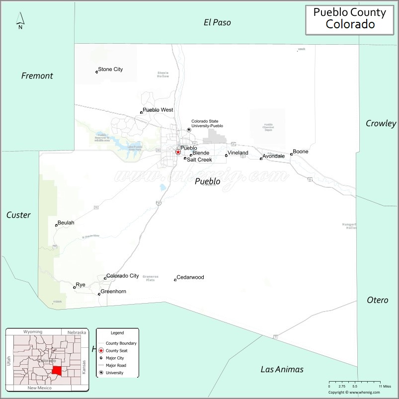
About Pueblo County Map, Colorado: The map showing the county boundary, county seat, major cities, highways, water bodies and neighbouring counties.
Most Viewed Links
Map of Pueblo County, Colorado
Pueblo County is a county located in the U.S. state of Colorado. It's county seat is Pueblo. As per 2020 census, the population of Pueblo County is 169622 people and population density is square miles. According to the United States Census Bureau, the county has a total area of 2,396.77 sq mi (6,208 km2). Pueblo County was established on -13938.
Pueblo County Facts
| Continent | North America |
| Country | United States |
| State | Colorado |
| County Seat | Pueblo |
| Largest City/Town | Pueblo |
| Established | 1861 |
| Total Area | 2,397 sq mi (6,208 sq km) |
| Land Area | 2,386 sq mi (6,180 sq km) |
| Water Area | 11 sq mi (28 sq km) |
| Population | 168,162 (Census 2020) |
| Population Density | 70.5 people per sq mi |
| Time Zone | Mountain Time Zone (MST/MDT) |
| Major Highways | Interstate 25, US Highway 50, State Highway 96, State Highway 78 |
| Major Rivers | Arkansas River, Fountain Creek, St. Charles River |
| Neighboring Counties | El Paso County, Fremont County, Custer County, Huerfano County, Otero County, Crowley County |
| Famous For | Steel industry history, Arkansas River, Pueblo chile peppers, and cultural heritage |
| Top Attractions | Pueblo Riverwalk, Lake Pueblo State Park, Historic Arkansas Riverwalk, Bishop Castle nearby |
| Official Website | Official Website |
About Pueblo County, Colorado
Pueblo County is located in southern Colorado in the United States and was established in 1861 as one of the original counties of the Colorado Territory. The county seat and largest city is Pueblo. The county is known for steel manufacturing history, cultural diversity, agriculture, outdoor recreation, and the Arkansas River corridor.
Cities and Towns in Pueblo County, Colorado
| City/Town | Population (Census 2020) | Latitude & Longitude |
|---|---|---|
| Pueblo (county seat) | 111,876 | 38.2544°N, 104.6091°W |
| Pueblo West (CDP) | 34,114 | 38.3528°N, 104.7227°W |
| Boone | 284 | 38.2625°N, 104.2553°W |
| Rye | 153 | 37.9186°N, 104.9314°W |
| Avondale | 674 | 38.2375°N, 104.3892°W |
| Vineland | 269 | 38.2389°N, 104.4919°W |
| Colorado City | 2,112 | 37.9453°N, 104.8353°W |
| Beulah Valley | Mountain community | 38.0756°N, 104.9867°W |
Golf Courses in Pueblo County, Colorado
| Golf Course | Location | Latitude & Longitude |
|---|---|---|
| Walking Stick Golf Course | Pueblo | 38.2861°N, 104.5672°W |
| Pueblo Country Club | Pueblo | 38.3008°N, 104.6219°W |
| Desert Hawk Golf Course | Pueblo West | 38.3558°N, 104.7386°W |
| Elmwood Golf Course | Pueblo | 38.2825°N, 104.6200°W |
Roads and Highways in Pueblo County, Colorado
Major highways connect the county to southern Colorado communities and interstate transportation routes.
- Interstate 25 - major north-south interstate connecting Pueblo with Denver, Colorado Springs, and New Mexico
- US Highway 50 - east-west route linking Pueblo with western Colorado and Kansas
- Colorado State Highway 96 - regional highway serving southeastern Colorado communities
- Colorado State Highway 78 - scenic route connecting Pueblo with the Wet Mountain Valley region
Neighboring Counties of Pueblo County
- El Paso County (north)
- Fremont County (west)
- Custer County (west)
- Huerfano County (southwest)
- Otero County (east)
- Crowley County (northeast)
Top Attractions in Pueblo County, Colorado
The county offers a mix of cultural, historical, and outdoor recreation attractions.
- Historic Arkansas Riverwalk of Pueblo - downtown waterfront attraction with restaurants, shops, and boat rides
- Lake Pueblo State Park - boating, camping, fishing, and hiking destination
- Pueblo Zoo - family-friendly zoo featuring wildlife exhibits and educational programs
- Union Avenue Historic District - preserved historic district with restaurants and local businesses
- Pueblo Weisbrod Aircraft Museum - aviation and military history museum
- Bishop Castle nearby - unique handmade stone castle attraction in the mountains
- Arkansas River Trail System - biking, walking, and riverside recreation paths
- Rosemount Museum - historic Victorian mansion and cultural landmark
- Pueblo Chile & Frijoles Festival - annual event celebrating local food and culture
- Nature and Wildlife Discovery Center - environmental education and outdoor recreation area
- San Isabel National Forest nearby - mountain recreation and hiking opportunities
- Steelworks Museum - exhibits on Pueblo’s steel and industrial history
Distance from Pueblo County to Nearby Cities
The following distances are measured by road (driving).
- Pueblo to Colorado Springs (El Paso County), Colorado - 45 mi (72 km)
- Pueblo to Cañon City (Fremont County), Colorado - 40 mi (64 km)
- Pueblo to Walsenburg (Huerfano County), Colorado - 51 mi (82 km)
- Pueblo to Denver (Denver County), Colorado - 113 mi (182 km)
- Pueblo to La Junta (Otero County), Colorado - 60 mi (97 km)
- Pueblo to Salida (Chaffee County), Colorado - 100 mi (161 km)
- Pueblo to Trinidad (Las Animas County), Colorado - 84 mi (135 km)
- Pueblo to Grand Junction (Mesa County), Colorado - 285 mi (459 km)
- Pueblo to Amarillo (Potter County), Texas - 307 mi (494 km)
- Pueblo to Santa Fe (Santa Fe County), New Mexico - 235 mi (378 km)
- Pueblo to Albuquerque (Bernalillo County), New Mexico - 347 mi (558 km)
- Pueblo to Wichita (Sedgwick County), Kansas - 339 mi (546 km)
FAQs about Pueblo County
Pueblo County is located in southern Colorado along the Arkansas River in the United States.
The population of Pueblo County was 168,162 according to the Census 2020.
Pueblo County is known for its steel industry history, Pueblo chile peppers, Arkansas River attractions, and cultural heritage.
The county is served by Interstate 25, US Highway 50, Colorado State Highway 96, and Colorado State Highway 78.
Popular attractions include the Pueblo Riverwalk, Lake Pueblo State Park, Pueblo Zoo, and the Steelworks Museum.
References
- QuickFacts - U.S. Census Bureau
- United States Census Bureau
- United States Geological Survey (USGS)
- National Geodetic Survey
- Official Website
- Adams County Map
- Alamosa County Map
- Arapahoe County Map
- Archuleta County Map
- Baca County Map
- Bent County Map
- Boulder County Map
- Broomfield County Map
- Chaffee County Map
- Cheyenne County Map
- Clear Creek County Map
- Conejos County Map
- Costilla County Map
- Crowley County Map
- Custer County Map
- Delta County Map
- Denver County Map
- Dolores County Map
- Douglas County Map
- Eagle County Map
- Elbert County Map
- El Paso County Map
- Fremont County Map
- Garfield County Map
- Gilpin County Map
- Grand County Map
- Gunnison County Map
- Hinsdale County Map
- Huerfano County Map
- Jackson County Map
- Jefferson County Map
- Kiowa County Map
- Kit Carson County Map
- Lake County Map
- La Plata County Map
- Larimer County Map
- Las Animas County Map
- Lincoln County Map
- Logan County Map
- Mesa County Map
- Mineral County Map
- Moffat County Map
- Montezuma County Map
- Montrose County Map
- Morgan County Map
- Otero County Map
- Ouray County Map
- Park County Map
- Phillips County Map
- Pitkin County Map
- Prowers County Map
- Pueblo County Map
- Rio Blanco County Map
- Rio Grande County Map
- Routt County Map
- Saguache County Map
- San Juan County Map
- San Miguel County Map
- Sedgwick County Map
- Summit County Map
- Teller County Map
- Washington County Map
- Weld County Map
- Yuma County Map
- Alabama Counties
- Alaska boroughs
- Arizona Counties
- Arkansas Counties
- California County Map
- Colorado Counties
- Connecticut Counties
- Delaware Counties
- Florida County Map
- Georgia County Map
- Hawaii Counties
- Idaho Counties
- Illinois Counties
- Indiana Counties
- Iowa Counties
- Kansas Counties
- Kentucky Counties
- Louisiana Counties
- Maine Counties
- Maryland Counties
- Massachusetts Counties
- Michigan County Map
- Minnesota Counties
- Mississippi Counties
- Missouri Counties
- Montana Counties
- Nebraska Counties
- Nevada Counties
- New York Counties
- New Hampshire Counties
- New Jersey Counties
- New Mexico Counties
- North Carolina Counties
- North Dakota Counties
- Ohio County Map
- Oklahoma Counties
- Oregon Counties
- Pennsylvania Counties
- Rhode Island Counties
- South Carolina Counties
- South Dakota Counties
- Map of Tennessee
- Texas County Map
- Utah Counties
- Vermont Counties
- Virginia Counties
- Washington Counties
- West Virginia Counties
- Wisconsin Counties
- Wyoming Counties