Map of Lake County - Lake County is a county located in the U.S. state of Colorado. Lake County Map showing cities, highways, important places and water bodies. Get Where is Lake County located in the map, major cities in Lake county, population, areas, and places of interest.
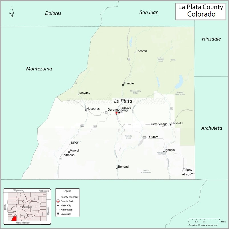
Map of La Plata County, Colorado
About Lake County Map, Colorado: The map showing the county boundary, county seat, major cities, highways, water bodies and neighbouring counties.
Most Viewed Links
Map of La Plata County, Colorado
La Plata County is a county located in the U.S. state of Colorado. It's county seat is Durango. As per 2020 census, the population of La Plata County is 56250 people and population density is square miles. According to the United States Census Bureau, the county has a total area of 1,700.44 sq mi (4,404 km2). La Plata County was established on -9454.
La Plata County Facts
| Continent | North America |
| Country | United States |
| State | Colorado |
| County Seat | Durango |
| Largest City/Town | Durango |
| Established | 1874 |
| Total Area | 1,700 sq mi (4,403 sq km) |
| Land Area | 1,692 sq mi (4,383 sq km) |
| Water Area | 8 sq mi (20 sq km) |
| Population | 55,533 (Census 2020) |
| Population Density | 32.8 people per sq mi |
| Time Zone | Mountain Time Zone (MST/MDT) |
| Major Highways | US Highway 160, US Highway 550, State Highway 172 |
| Major Rivers | Animas River, La Plata River |
| Neighboring Counties | Montezuma County, San Juan County, Hinsdale County, Archuleta County, San Juan County (NM) |
| Famous For | Durango, mountain recreation, historic railroads, skiing, and San Juan Mountain scenery |
| Top Attractions | Durango & Silverton Narrow Gauge Railroad, Purgatory Resort, Mesa Verde nearby, Animas River |
| Official Website | Official Website |
About La Plata County, Colorado
La Plata County is located in southwestern Colorado in the United States and was established in 1874. The county seat and largest city is Durango. The county is known for mountain scenery, outdoor recreation, historic railroads, skiing, river activities, and tourism in the San Juan Mountains region.
Cities and Towns in La Plata County, Colorado
| City/Town | Population (Census 2020) | Latitude & Longitude |
|---|---|---|
| Durango (county seat) | 19,071 | 37.2753°N, 107.8801°W |
| Bayfield | 2,838 | 37.2256°N, 107.5987°W |
| Ignacio | 852 | 37.1153°N, 107.6331°W |
| Hermosa | 2,100 | 37.4339°N, 107.8392°W |
| Forest Lakes (CDP) | 426 | 37.4633°N, 107.5278°W |
| Vallecito (CDP) | 406 | 37.3728°N, 107.5756°W |
| Oxford (CDP) | 610 | 37.1603°N, 107.7531°W |
| Rockwood (historic site) | Historic railroad stop | 37.4722°N, 107.8050°W |
Golf Courses in La Plata County, Colorado
| Golf Course | Location | Latitude & Longitude |
|---|---|---|
| Hillcrest Golf Club | Durango | 37.2981°N, 107.8742°W |
| Dalton Ranch Golf Club | Durango | 37.4489°N, 107.8353°W |
| Conquistador Golf Course | Cortez nearby | 37.3494°N, 108.5889°W |
| Pagosa Springs Golf Club | Pagosa Springs nearby | 37.2694°N, 107.0372°W |
Roads and Highways in La Plata County, Colorado
Major highways connect the county to mountain resorts, New Mexico, and southwestern Colorado communities.
- US Highway 160 - major east-west highway connecting Durango with Pagosa Springs and Cortez
- US Highway 550 - scenic route linking Durango with Silverton, Montrose, and New Mexico
- Colorado State Highway 172 - route connecting Ignacio with southern La Plata County and New Mexico
Neighboring Counties of La Plata County
- Hinsdale County (north)
- San Juan County, Colorado (northwest)
- Montezuma County (west)
- Archuleta County (east)
- San Juan County, New Mexico (south)
Top Attractions in La Plata County, Colorado
The county offers a mix of natural, recreational, and historical attractions.
- Durango & Silverton Narrow Gauge Railroad - historic scenic train ride through the San Juan Mountains
- Purgatory Resort - ski resort offering winter sports and summer mountain recreation
- Animas River Trail - riverside recreation path through Durango
- Mesa Verde National Park nearby - UNESCO World Heritage Site featuring ancient cliff dwellings
- San Juan National Forest - forest recreation area with hiking, camping, and fishing
- Vallecito Lake - reservoir popular for boating, camping, and fishing
- Historic Downtown Durango - restaurants, galleries, shops, and preserved architecture
- Durango Hot Springs Resort - geothermal pools and spa destination
- Engineer Mountain and Hermosa Creek areas - hiking and mountain biking destinations
- Fort Lewis College overlook areas - scenic views of Durango and surrounding mountains
- James Ranch and local farms - agritourism and local food attractions
- Pinkerton Hot Springs - roadside geothermal spring landmark
Distance from La Plata County to Nearby Cities
The following distances are measured by road (driving).
- Durango to Cortez (Montezuma County), Colorado - 46 mi (74 km)
- Durango to Pagosa Springs (Archuleta County), Colorado - 60 mi (97 km)
- Durango to Silverton (San Juan County), Colorado - 48 mi (77 km)
- Durango to Farmington (San Juan County), New Mexico - 48 mi (77 km)
- Durango to Telluride (San Miguel County), Colorado - 111 mi (179 km)
- Durango to Montrose (Montrose County), Colorado - 129 mi (208 km)
- Durango to Alamosa (Alamosa County), Colorado - 148 mi (238 km)
- Durango to Santa Fe (Santa Fe County), New Mexico - 215 mi (346 km)
- Durango to Grand Junction (Mesa County), Colorado - 164 mi (264 km)
- Durango to Denver (Denver County), Colorado - 337 mi (542 km)
- Durango to Moab (Grand County), Utah - 167 mi (269 km)
- Durango to Phoenix (Maricopa County), Arizona - 454 mi (731 km)
FAQs about La Plata County
La Plata County is located in southwestern Colorado within the San Juan Mountains region of the United States.
The population of La Plata County was 55,533 according to the Census 2020.
La Plata County is known for Durango, mountain recreation, skiing, historic railroads, and scenic San Juan Mountain landscapes.
The county is served by US Highway 160, US Highway 550, and Colorado State Highway 172.
Popular attractions include the Durango & Silverton Narrow Gauge Railroad, Purgatory Resort, Vallecito Lake, and the Animas River.
References
- QuickFacts - U.S. Census Bureau
- United States Census Bureau
- United States Geological Survey (USGS)
- National Geodetic Survey
- Official Website
- Adams County Map
- Alamosa County Map
- Arapahoe County Map
- Archuleta County Map
- Baca County Map
- Bent County Map
- Boulder County Map
- Broomfield County Map
- Chaffee County Map
- Cheyenne County Map
- Clear Creek County Map
- Conejos County Map
- Costilla County Map
- Crowley County Map
- Custer County Map
- Delta County Map
- Denver County Map
- Dolores County Map
- Douglas County Map
- Eagle County Map
- Elbert County Map
- El Paso County Map
- Fremont County Map
- Garfield County Map
- Gilpin County Map
- Grand County Map
- Gunnison County Map
- Hinsdale County Map
- Huerfano County Map
- Jackson County Map
- Jefferson County Map
- Kiowa County Map
- Kit Carson County Map
- Lake County Map
- La Plata County Map
- Larimer County Map
- Las Animas County Map
- Lincoln County Map
- Logan County Map
- Mesa County Map
- Mineral County Map
- Moffat County Map
- Montezuma County Map
- Montrose County Map
- Morgan County Map
- Otero County Map
- Ouray County Map
- Park County Map
- Phillips County Map
- Pitkin County Map
- Prowers County Map
- Pueblo County Map
- Rio Blanco County Map
- Rio Grande County Map
- Routt County Map
- Saguache County Map
- San Juan County Map
- San Miguel County Map
- Sedgwick County Map
- Summit County Map
- Teller County Map
- Washington County Map
- Weld County Map
- Yuma County Map
- Alabama Counties
- Alaska boroughs
- Arizona Counties
- Arkansas Counties
- California County Map
- Colorado Counties
- Connecticut Counties
- Delaware Counties
- Florida County Map
- Georgia County Map
- Hawaii Counties
- Idaho Counties
- Illinois Counties
- Indiana Counties
- Iowa Counties
- Kansas Counties
- Kentucky Counties
- Louisiana Counties
- Maine Counties
- Maryland Counties
- Massachusetts Counties
- Michigan County Map
- Minnesota Counties
- Mississippi Counties
- Missouri Counties
- Montana Counties
- Nebraska Counties
- Nevada Counties
- New York Counties
- New Hampshire Counties
- New Jersey Counties
- New Mexico Counties
- North Carolina Counties
- North Dakota Counties
- Ohio County Map
- Oklahoma Counties
- Oregon Counties
- Pennsylvania Counties
- Rhode Island Counties
- South Carolina Counties
- South Dakota Counties
- Map of Tennessee
- Texas County Map
- Utah Counties
- Vermont Counties
- Virginia Counties
- Washington Counties
- West Virginia Counties
- Wisconsin Counties
- Wyoming Counties