Map of Pitkin County - Pitkin County is a county located in the U.S. state of Colorado. Pitkin County Map showing cities, highways, important places and water bodies. Get Where is Pitkin County located in the map, major cities in Pitkin county, population, areas, and places of interest.
Map of Pitkin County, Colorado
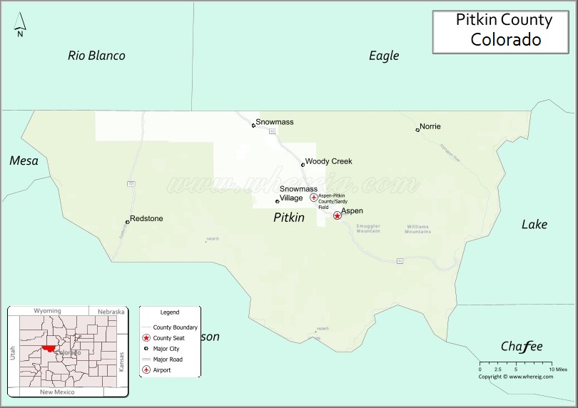
About Pitkin County Map, Colorado: The map showing the county boundary, county seat, major cities, highways, water bodies and neighbouring counties.
Most Viewed Links
Map of Pitkin County, Colorado
Pitkin County is a county located in the U.S. state of Colorado. It's county seat is Aspen. As per 2020 census, the population of Pitkin County is 17348 people and population density is square miles. According to the United States Census Bureau, the county has a total area of 970.37 sq mi (2,513 km2). Pitkin County was established on -6884.
Pitkin County Facts
| Continent | North America |
| Country | United States |
| State | Colorado |
| County Seat | Aspen |
| Largest City/Town | Aspen |
| Established | 1881 |
| Total Area | 973 sq mi (2,520 sq km) |
| Land Area | 971 sq mi (2,515 sq km) |
| Water Area | 2 sq mi (5 sq km) |
| Population | 17,358 (Census 2020) |
| Population Density | 17.9 people per sq mi |
| Time Zone | Mountain Time Zone (MST/MDT) |
| Major Highways | State Highway 82 |
| Major Rivers | Roaring Fork River, Crystal River |
| Neighboring Counties | Eagle County, Garfield County, Gunnison County, Lake County, Chaffee County |
| Famous For | Aspen ski resorts, luxury tourism, mountain scenery, and outdoor recreation |
| Top Attractions | Aspen Mountain, Maroon Bells, Snowmass Village, Independence Pass |
| Official Website | Official Website |
About Pitkin County, Colorado
Pitkin County is located in central Colorado in the United States and was established in 1881. The county seat and largest city is Aspen. The county is known for world-famous ski resorts, alpine scenery, luxury tourism, cultural festivals, and year-round outdoor recreation in the Rocky Mountains.
Cities and Communities in Pitkin County, Colorado
| City/Town | Population (Census 2020) | Latitude & Longitude |
|---|---|---|
| Aspen (county seat) | 7,004 | 39.1911°N, 106.8175°W |
| Snowmass Village | 3,056 | 39.2130°N, 106.9378°W |
| Woody Creek | 290 | 39.2694°N, 106.8936°W |
| Basalt (partly) | 3,984 | 39.3689°N, 107.0328°W |
| Redstone nearby area | Historic mountain community | 39.1844°N, 107.2389°W |
| Ashcroft Ghost Town | Historic site | 39.0008°N, 106.8025°W |
| Maroon Creek area | Scenic recreation region | 39.0989°N, 106.9439°W |
| Independence Pass area | Mountain recreation region | 39.1086°N, 106.5622°W |
Golf Courses in Pitkin County, Colorado
| Golf Course | Location | Latitude & Longitude |
|---|---|---|
| Aspen Golf Club | Aspen | 39.2044°N, 106.8392°W |
| Snowmass Club Golf Course | Snowmass Village | 39.1886°N, 106.9481°W |
| River Valley Ranch Golf Club | Carbondale nearby | 39.4044°N, 107.2128°W |
Roads and Highways in Pitkin County, Colorado
Major highways connect the county to central Colorado mountain communities and recreation areas.
- Colorado State Highway 82 - scenic mountain highway connecting Aspen with Glenwood Springs and Independence Pass
Neighboring Counties of Pitkin County
- Eagle County (north)
- Garfield County (northwest)
- Gunnison County (south)
- Lake County (east)
- Chaffee County (southeast)
Top Attractions in Pitkin County, Colorado
The county offers a mix of luxury tourism, outdoor recreation, and scenic mountain attractions.
- Maroon Bells - iconic mountain peaks and one of Colorado’s most photographed scenic locations
- Aspen Mountain Ski Resort - famous ski destination located above downtown Aspen
- Snowmass Village - major ski and recreation resort area
- Independence Pass - scenic high-altitude mountain pass with panoramic views
- Aspen Music Festival and School - internationally known summer music and cultural event
- Ashcroft Ghost Town - preserved mining-era ghost town near Aspen
- Roaring Fork River recreation areas - fishing, rafting, and hiking opportunities
- John Denver Sanctuary - riverside memorial park and garden in Aspen
- White River National Forest recreation areas - hiking, camping, and mountain biking trails
- Aspen Highlands and Buttermilk ski areas - winter sports and scenic alpine recreation
- Castle Creek Valley - scenic mountain drive with historic sites and hiking trails
- Downtown Aspen - luxury shopping, restaurants, galleries, and cultural attractions
Distance from Pitkin County to Nearby Cities
The following distances are measured by road (driving).
- Aspen to Glenwood Springs (Garfield County), Colorado - 41 mi (66 km)
- Aspen to Vail (Eagle County), Colorado - 102 mi (164 km)
- Aspen to Leadville (Lake County), Colorado - 58 mi (93 km)
- Aspen to Gunnison (Gunnison County), Colorado - 109 mi (175 km)
- Aspen to Grand Junction (Mesa County), Colorado - 125 mi (201 km)
- Aspen to Denver (Denver County), Colorado - 199 mi (320 km)
- Aspen to Colorado Springs (El Paso County), Colorado - 221 mi (356 km)
- Aspen to Breckenridge (Summit County), Colorado - 96 mi (154 km)
- Aspen to Montrose (Montrose County), Colorado - 146 mi (235 km)
- Aspen to Moab (Grand County), Utah - 244 mi (393 km)
- Aspen to Salt Lake City (Salt Lake County), Utah - 354 mi (570 km)
- Aspen to Santa Fe (Santa Fe County), New Mexico - 356 mi (573 km)
FAQs about Pitkin County
Pitkin County is located in central Colorado within the Rocky Mountains region of the United States.
The population of Pitkin County was 17,358 according to the Census 2020.
Pitkin County is known for Aspen ski resorts, luxury tourism, alpine scenery, and outdoor recreation.
The county is primarily served by Colorado State Highway 82.
Popular attractions include Maroon Bells, Aspen Mountain, Snowmass Village, and Independence Pass.
References
- QuickFacts - U.S. Census Bureau
- United States Census Bureau
- United States Geological Survey (USGS)
- National Geodetic Survey
- Official Website
- Adams County Map
- Alamosa County Map
- Arapahoe County Map
- Archuleta County Map
- Baca County Map
- Bent County Map
- Boulder County Map
- Broomfield County Map
- Chaffee County Map
- Cheyenne County Map
- Clear Creek County Map
- Conejos County Map
- Costilla County Map
- Crowley County Map
- Custer County Map
- Delta County Map
- Denver County Map
- Dolores County Map
- Douglas County Map
- Eagle County Map
- Elbert County Map
- El Paso County Map
- Fremont County Map
- Garfield County Map
- Gilpin County Map
- Grand County Map
- Gunnison County Map
- Hinsdale County Map
- Huerfano County Map
- Jackson County Map
- Jefferson County Map
- Kiowa County Map
- Kit Carson County Map
- Lake County Map
- La Plata County Map
- Larimer County Map
- Las Animas County Map
- Lincoln County Map
- Logan County Map
- Mesa County Map
- Mineral County Map
- Moffat County Map
- Montezuma County Map
- Montrose County Map
- Morgan County Map
- Otero County Map
- Ouray County Map
- Park County Map
- Phillips County Map
- Pitkin County Map
- Prowers County Map
- Pueblo County Map
- Rio Blanco County Map
- Rio Grande County Map
- Routt County Map
- Saguache County Map
- San Juan County Map
- San Miguel County Map
- Sedgwick County Map
- Summit County Map
- Teller County Map
- Washington County Map
- Weld County Map
- Yuma County Map
- Alabama Counties
- Alaska boroughs
- Arizona Counties
- Arkansas Counties
- California County Map
- Colorado Counties
- Connecticut Counties
- Delaware Counties
- Florida County Map
- Georgia County Map
- Hawaii Counties
- Idaho Counties
- Illinois Counties
- Indiana Counties
- Iowa Counties
- Kansas Counties
- Kentucky Counties
- Louisiana Counties
- Maine Counties
- Maryland Counties
- Massachusetts Counties
- Michigan County Map
- Minnesota Counties
- Mississippi Counties
- Missouri Counties
- Montana Counties
- Nebraska Counties
- Nevada Counties
- New York Counties
- New Hampshire Counties
- New Jersey Counties
- New Mexico Counties
- North Carolina Counties
- North Dakota Counties
- Ohio County Map
- Oklahoma Counties
- Oregon Counties
- Pennsylvania Counties
- Rhode Island Counties
- South Carolina Counties
- South Dakota Counties
- Map of Tennessee
- Texas County Map
- Utah Counties
- Vermont Counties
- Virginia Counties
- Washington Counties
- West Virginia Counties
- Wisconsin Counties
- Wyoming Counties