Map of La Plata County - La Plata County is a county located in the U.S. state of Colorado. La Plata County Map showing cities, highways, important places and water bodies. Get Where is La Plata County located in the map, major cities in La Plata county, population, areas, and places of interest.
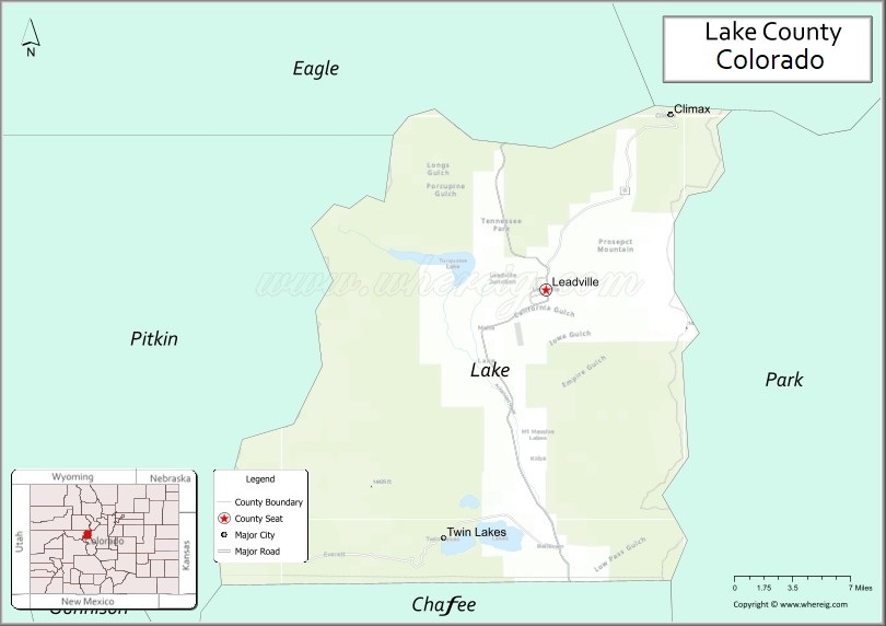
Map of Lake County, Colorado
About La Plata County Map, Colorado: The map showing the county boundary, county seat, major cities, highways, water bodies and neighbouring counties.
Most Viewed Links
Map of Lake County, Colorado
Lake County is a county located in the U.S. state of Colorado. It's county seat is Leadville. As per 2020 census, the population of Lake County is 7407 people and population density is square miles. According to the United States Census Bureau, the county has a total area of 383.55 sq mi (993 km2). Lake County was established on -13938.
Lake County Facts
| Continent | North America |
| Country | United States |
| State | Colorado |
| County Seat | Leadville |
| Largest City/Town | Leadville |
| Established | 1877 |
| Total Area | 384 sq mi (995 sq km) |
| Land Area | 377 sq mi (976 sq km) |
| Water Area | 7 sq mi (18 sq km) |
| Population | 7,436 (Census 2020) |
| Population Density | 19.7 people per sq mi |
| Time Zone | Mountain Time Zone (MST/MDT) |
| Major Highways | US Highway 24, State Highway 91, State Highway 82 |
| Major Rivers | Arkansas River, Lake Fork Arkansas River |
| Neighboring Counties | Summit County, Eagle County, Pitkin County, Chaffee County, Park County |
| Famous For | Leadville, mining history, high-altitude scenery, and outdoor recreation |
| Top Attractions | Leadville Historic District, Twin Lakes, Mount Elbert, Turquoise Lake |
| Official Website | Official Website |
About Lake County, Colorado
Lake County is located in central Colorado in the United States and was established in 1877. The county seat and largest city is Leadville. The county is known for mining history, mountain scenery, alpine lakes, high-elevation recreation, and some of Colorado’s tallest mountain peaks.
Cities and Communities in Lake County, Colorado
| City/Town | Population (Census 2020) | Latitude & Longitude |
|---|---|---|
| Leadville (county seat) | 2,633 | 39.2508°N, 106.2925°W |
| Twin Lakes (CDP) | 171 | 39.0825°N, 106.3817°W |
| Turquoise Lake communities | Regional area | 39.2794°N, 106.3742°W |
| Climax (historic mining area) | Historic site | 39.3675°N, 106.1831°W |
| Leadville North (CDP) | 1,648 | 39.2769°N, 106.3042°W |
| Stringtown (historic community) | Historic site | 39.2525°N, 106.2950°W |
Golf Courses in Lake County, Colorado
| Golf Course | Location | Latitude & Longitude |
|---|---|---|
| Mount Massive Golf Course | Leadville | 39.2522°N, 106.3139°W |
| Copper Creek Golf Course | Copper Mountain nearby | 39.5025°N, 106.1514°W |
| Breckenridge Golf Club | Breckenridge nearby | 39.5142°N, 106.0328°W |
Roads and Highways in Lake County, Colorado
Major highways connect the county to mountain passes, ski resorts, and central Colorado recreation areas.
- US Highway 24 - major route connecting Leadville with Buena Vista, Minturn, and Colorado Springs
- Colorado State Highway 91 - highway linking Leadville with Copper Mountain and Interstate 70
- Colorado State Highway 82 - scenic route connecting Twin Lakes with Independence Pass and Aspen
Neighboring Counties of Lake County
- Summit County (north)
- Eagle County (northwest)
- Pitkin County (west)
- Chaffee County (south)
- Park County (east)
Top Attractions in Lake County, Colorado
The county offers a mix of natural and historical attractions.
- Leadville Historic District - preserved mining-era downtown with museums and Victorian buildings
- Twin Lakes - scenic alpine lakes popular for boating, fishing, and camping
- Mount Elbert - highest mountain peak in Colorado and a major hiking destination
- Turquoise Lake Recreation Area - reservoir with camping, fishing, and mountain scenery
- Leadville Colorado & Southern Railroad - scenic train rides through mountain landscapes
- National Mining Hall of Fame and Museum - museum dedicated to mining history and heritage
- Independence Pass nearby - scenic mountain pass connecting to Aspen
- Mount Massive Wilderness - hiking and backpacking destination in the Sawatch Range
- Climax Mine Area - historic molybdenum mining region
- Arkansas Headwaters Recreation Area - rafting, fishing, and outdoor recreation
- Mineral Belt Trail - paved recreation trail circling Leadville with mountain views
- Camp Hale Historic Area nearby - former military training site and recreation area
Distance from Lake County to Nearby Cities
The following distances are measured by road (driving).
- Leadville to Breckenridge (Summit County), Colorado - 45 mi (72 km)
- Leadville to Aspen (Pitkin County), Colorado - 104 mi (167 km)
- Leadville to Vail (Eagle County), Colorado - 52 mi (84 km)
- Leadville to Buena Vista (Chaffee County), Colorado - 34 mi (55 km)
- Leadville to Denver (Denver County), Colorado - 101 mi (163 km)
- Leadville to Colorado Springs (El Paso County), Colorado - 126 mi (203 km)
- Leadville to Glenwood Springs (Garfield County), Colorado - 85 mi (137 km)
- Leadville to Salida (Chaffee County), Colorado - 61 mi (98 km)
- Leadville to Grand Junction (Mesa County), Colorado - 173 mi (278 km)
- Leadville to Gunnison (Gunnison County), Colorado - 105 mi (169 km)
- Leadville to Estes Park (Larimer County), Colorado - 157 mi (253 km)
- Leadville to Moab (Grand County), Utah - 282 mi (454 km)
FAQs about Lake County
Lake County is located in central Colorado within the Rocky Mountains region of the United States.
The population of Lake County was 7,436 according to the Census 2020.
Lake County is known for Leadville, mining history, alpine lakes, and Colorado's high mountain peaks.
The county is served by US Highway 24, Colorado State Highway 91, and Colorado State Highway 82.
Popular attractions include Leadville Historic District, Twin Lakes, Mount Elbert, and Turquoise Lake Recreation Area.
References
- QuickFacts - U.S. Census Bureau
- United States Census Bureau
- United States Geological Survey (USGS)
- National Geodetic Survey
- Official Website
- Adams County Map
- Alamosa County Map
- Arapahoe County Map
- Archuleta County Map
- Baca County Map
- Bent County Map
- Boulder County Map
- Broomfield County Map
- Chaffee County Map
- Cheyenne County Map
- Clear Creek County Map
- Conejos County Map
- Costilla County Map
- Crowley County Map
- Custer County Map
- Delta County Map
- Denver County Map
- Dolores County Map
- Douglas County Map
- Eagle County Map
- Elbert County Map
- El Paso County Map
- Fremont County Map
- Garfield County Map
- Gilpin County Map
- Grand County Map
- Gunnison County Map
- Hinsdale County Map
- Huerfano County Map
- Jackson County Map
- Jefferson County Map
- Kiowa County Map
- Kit Carson County Map
- Lake County Map
- La Plata County Map
- Larimer County Map
- Las Animas County Map
- Lincoln County Map
- Logan County Map
- Mesa County Map
- Mineral County Map
- Moffat County Map
- Montezuma County Map
- Montrose County Map
- Morgan County Map
- Otero County Map
- Ouray County Map
- Park County Map
- Phillips County Map
- Pitkin County Map
- Prowers County Map
- Pueblo County Map
- Rio Blanco County Map
- Rio Grande County Map
- Routt County Map
- Saguache County Map
- San Juan County Map
- San Miguel County Map
- Sedgwick County Map
- Summit County Map
- Teller County Map
- Washington County Map
- Weld County Map
- Yuma County Map
- Alabama Counties
- Alaska boroughs
- Arizona Counties
- Arkansas Counties
- California County Map
- Colorado Counties
- Connecticut Counties
- Delaware Counties
- Florida County Map
- Georgia County Map
- Hawaii Counties
- Idaho Counties
- Illinois Counties
- Indiana Counties
- Iowa Counties
- Kansas Counties
- Kentucky Counties
- Louisiana Counties
- Maine Counties
- Maryland Counties
- Massachusetts Counties
- Michigan County Map
- Minnesota Counties
- Mississippi Counties
- Missouri Counties
- Montana Counties
- Nebraska Counties
- Nevada Counties
- New York Counties
- New Hampshire Counties
- New Jersey Counties
- New Mexico Counties
- North Carolina Counties
- North Dakota Counties
- Ohio County Map
- Oklahoma Counties
- Oregon Counties
- Pennsylvania Counties
- Rhode Island Counties
- South Carolina Counties
- South Dakota Counties
- Map of Tennessee
- Texas County Map
- Utah Counties
- Vermont Counties
- Virginia Counties
- Washington Counties
- West Virginia Counties
- Wisconsin Counties
- Wyoming Counties