Map of El Paso County - El Paso County is a county located in the U.S. state of Colorado. El Paso County Map showing cities, highways, important places and water bodies. Get Where is El Paso County located in the map, major cities in El Paso county, population, areas, and places of interest.
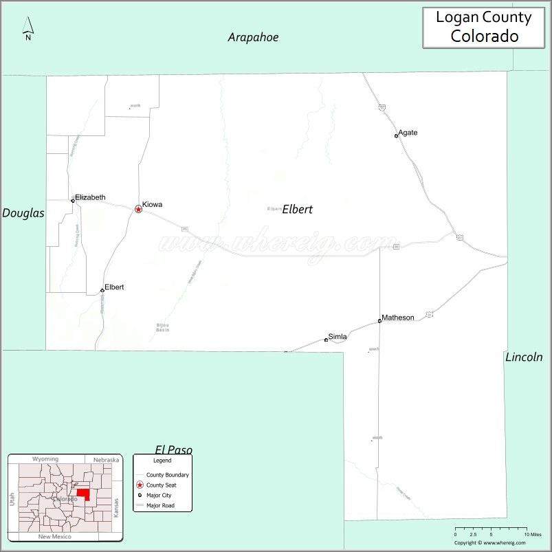
Map of Elbert County, Colorado
About El Paso County Map, Colorado: The map showing the county boundary, county seat, major cities, highways, water bodies and neighbouring counties.
Most Viewed Links
Map of Elbert County, Colorado
Elbert County is a county located in the U.S. state of Colorado. It's county seat is Kiowa. As per 2020 census, the population of Elbert County is 27128 people and population density is square miles. According to the United States Census Bureau, the county has a total area of 1,849.08 sq mi (4,789 km2). Elbert County was established on -9462.
Elbert County Facts
| Continent | North America |
| Country | United States |
| State | Colorado |
| County Seat | Kiowa |
| Largest City/Town | Elizabeth |
| Established | 1874 |
| Total Area | 1,851 sq mi (4,794 sq km) |
| Land Area | 1,851 sq mi (4,794 sq km) |
| Water Area | 0.7 sq mi (1.8 sq km) |
| Population | 26,062 (Census 2020) |
| Population Density | 14.1 people per sq mi |
| Time Zone | Mountain Time Zone (MST/MDT) |
| Major Highways | State Highway 83, State Highway 86, State Highway 94 |
| Major Rivers | South Platte River watershed, Kiowa Creek |
| Neighboring Counties | Douglas County, Arapahoe County, El Paso County, Lincoln County, Adams County |
| Famous For | Ranching, rolling plains, rural communities, and scenic Front Range views |
| Top Attractions | Castlewood Canyon nearby, Agate fossil beds, ranch landscapes, Elizabeth parks |
| Official Website | Official Website |
About Elbert County, Colorado
Elbert County is located in east-central Colorado in the United States and was established in 1874. The county seat is Kiowa, while Elizabeth is the largest town. The county is known for ranching, open prairie landscapes, horse properties, rural living, and panoramic views of the Front Range mountains.
Cities and Towns in Elbert County, Colorado
| City/Town | Population (Census 2020) | Latitude & Longitude |
|---|---|---|
| Kiowa (county seat) | 725 | 39.3475°N, 104.4658°W |
| Elizabeth | 1,675 | 39.3600°N, 104.5950°W |
| Simla | 618 | 39.1411°N, 104.0844°W |
| Agate (CDP) | 38 | 39.4608°N, 103.9417°W |
| Elbert (CDP) | 230 | 39.2161°N, 104.5364°W |
| Matheson (CDP) | 79 | 39.1719°N, 103.9797°W |
| Ponderosa Park (CDP) | 3,400 | 39.3794°N, 104.7625°W |
| Comanche Creek (CDP) | 460 | 39.2750°N, 104.5661°W |
Golf Courses in Elbert County, Colorado
| Golf Course | Location | Latitude & Longitude |
|---|---|---|
| Spring Valley Golf Club | Elizabeth | 39.3703°N, 104.6078°W |
| Antler Creek Golf Course | Falcon nearby | 38.9642°N, 104.5931°W |
| Kings Deer Golf Club | Monument nearby | 39.1003°N, 104.8508°W |
Roads and Highways in Elbert County, Colorado
Major highways connect the county to the Denver metropolitan area, Colorado Springs, and eastern plains communities.
- Colorado State Highway 83 - north-south route connecting Elizabeth with Parker and Colorado Springs
- Colorado State Highway 86 - east-west route connecting Kiowa with Castle Rock and eastern Colorado
- Colorado State Highway 94 - highway connecting Elbert County with Colorado Springs and Lincoln County
Neighboring Counties of Elbert County
- Adams County (north)
- Arapahoe County (northwest)
- Douglas County (west)
- El Paso County (south)
- Lincoln County (east)
Top Attractions in Elbert County, Colorado
The county offers a mix of natural and historical attractions.
- Agate Fossil Beds Area - region known for fossil discoveries and prairie landscapes
- Castlewood Canyon State Park nearby - scenic canyon park with hiking trails and historic dam ruins
- Elbert County Fairgrounds - venue hosting rodeos, fairs, and community events
- Elizabeth Historic Downtown - small-town district with shops, restaurants, and local events
- Kiowa Creek Prairie Areas - scenic grasslands and ranching landscapes
- Ponderosa Pine Forest Areas - rolling hills and forested recreation spots in western Elbert County
- Russellville Historic Sites - rural pioneer and ranching heritage locations
- Comanche Creek Valley - scenic rural landscapes and wildlife viewing opportunities
- Bijou Basin Open Spaces - prairie scenery with birdwatching and photography opportunities
- Front Range Scenic Views - panoramic mountain vistas visible throughout western Elbert County
- Ramah Reservoir nearby - regional fishing and recreation destination
- Horse Ranch Communities - equestrian culture and riding areas popular throughout the county
Distance from Elbert County to Nearby Cities
The following distances are measured by road (driving).
- Kiowa to Castle Rock (Douglas County), Colorado - 26 mi (42 km)
- Kiowa to Denver (Denver County), Colorado - 41 mi (66 km)
- Kiowa to Colorado Springs (El Paso County), Colorado - 49 mi (79 km)
- Kiowa to Parker (Douglas County), Colorado - 20 mi (32 km)
- Kiowa to Limon (Lincoln County), Colorado - 57 mi (92 km)
- Kiowa to Aurora (Arapahoe County), Colorado - 32 mi (51 km)
- Kiowa to Pueblo (Pueblo County), Colorado - 93 mi (150 km)
- Kiowa to Fort Collins (Larimer County), Colorado - 105 mi (169 km)
- Kiowa to Burlington (Kit Carson County), Colorado - 125 mi (201 km)
- Kiowa to Canon City (Fremont County), Colorado - 92 mi (148 km)
- Kiowa to Estes Park (Larimer County), Colorado - 110 mi (177 km)
- Kiowa to Trinidad (Las Animas County), Colorado - 150 mi (241 km)
FAQs about Elbert County
Elbert County is located in east-central Colorado between the Front Range and eastern plains regions of the United States.
The population of Elbert County was 26,062 according to the Census 2020.
Elbert County is known for ranching, prairie landscapes, rural communities, and scenic views of the Rocky Mountains.
The county is served by Colorado State Highway 83, Colorado State Highway 86, and Colorado State Highway 94.
Yes, Elbert County has golf facilities including Spring Valley Golf Club and nearby regional golf courses.
References
- QuickFacts - U.S. Census Bureau
- United States Census Bureau
- United States Geological Survey (USGS)
- National Geodetic Survey
- Official Website
- Adams County Map
- Alamosa County Map
- Arapahoe County Map
- Archuleta County Map
- Baca County Map
- Bent County Map
- Boulder County Map
- Broomfield County Map
- Chaffee County Map
- Cheyenne County Map
- Clear Creek County Map
- Conejos County Map
- Costilla County Map
- Crowley County Map
- Custer County Map
- Delta County Map
- Denver County Map
- Dolores County Map
- Douglas County Map
- Eagle County Map
- Elbert County Map
- El Paso County Map
- Fremont County Map
- Garfield County Map
- Gilpin County Map
- Grand County Map
- Gunnison County Map
- Hinsdale County Map
- Huerfano County Map
- Jackson County Map
- Jefferson County Map
- Kiowa County Map
- Kit Carson County Map
- Lake County Map
- La Plata County Map
- Larimer County Map
- Las Animas County Map
- Lincoln County Map
- Logan County Map
- Mesa County Map
- Mineral County Map
- Moffat County Map
- Montezuma County Map
- Montrose County Map
- Morgan County Map
- Otero County Map
- Ouray County Map
- Park County Map
- Phillips County Map
- Pitkin County Map
- Prowers County Map
- Pueblo County Map
- Rio Blanco County Map
- Rio Grande County Map
- Routt County Map
- Saguache County Map
- San Juan County Map
- San Miguel County Map
- Sedgwick County Map
- Summit County Map
- Teller County Map
- Washington County Map
- Weld County Map
- Yuma County Map
- Alabama Counties
- Alaska boroughs
- Arizona Counties
- Arkansas Counties
- California County Map
- Colorado Counties
- Connecticut Counties
- Delaware Counties
- Florida County Map
- Georgia County Map
- Hawaii Counties
- Idaho Counties
- Illinois Counties
- Indiana Counties
- Iowa Counties
- Kansas Counties
- Kentucky Counties
- Louisiana Counties
- Maine Counties
- Maryland Counties
- Massachusetts Counties
- Michigan County Map
- Minnesota Counties
- Mississippi Counties
- Missouri Counties
- Montana Counties
- Nebraska Counties
- Nevada Counties
- New York Counties
- New Hampshire Counties
- New Jersey Counties
- New Mexico Counties
- North Carolina Counties
- North Dakota Counties
- Ohio County Map
- Oklahoma Counties
- Oregon Counties
- Pennsylvania Counties
- Rhode Island Counties
- South Carolina Counties
- South Dakota Counties
- Map of Tennessee
- Texas County Map
- Utah Counties
- Vermont Counties
- Virginia Counties
- Washington Counties
- West Virginia Counties
- Wisconsin Counties
- Wyoming Counties