Map of Delta County - Delta County is a county located in the U.S. state of Colorado. Delta County Map showing cities, highways, important places and water bodies. Get Where is Delta County located in the map, major cities in Delta county, population, areas, and places of interest.
Map of Delta County, Colorado
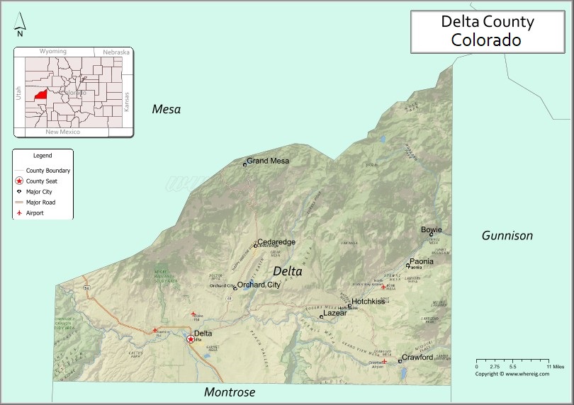
About Delta County Map, Colorado: The map showing the county boundary, county seat, major cities, highways, water bodies and neighbouring counties.
Most Viewed Links
Map of Delta County, Colorado
Delta County is a county located in the U.S. state of Colorado. It's county seat is Delta. As per 2020 census, the population of Delta County is 31661 people and population density is square miles. According to the United States Census Bureau, the county has a total area of 1,149.44 sq mi (2,977 km2). Delta County was established on -6166.
Delta County Facts
| Continent | North America |
| Country | United States |
| State | Colorado |
| County Seat | Delta |
| Largest City/Town | Delta |
| Established | 1883 |
| Total Area | 1,149 sq mi (2,976 sq km) |
| Land Area | 1,142 sq mi (2,957 sq km) |
| Water Area | 7 sq mi (18 sq km) |
| Population | 31,602 (Census 2020) |
| Population Density | 27.7 people per sq mi |
| Time Zone | Mountain Time Zone (MST/MDT) |
| Major Highways | US Highway 50, State Highway 92, State Highway 133, State Highway 348 |
| Major Rivers | Gunnison River, Uncompahgre River, North Fork Gunnison River |
| Neighboring Counties | Mesa County, Gunnison County, Montrose County, Ouray County, Pitkin County |
| Famous For | Fruit orchards, wineries, Black Canyon region, and Western Colorado mountain scenery |
| Top Attractions | Grand Mesa, Black Canyon nearby, Paonia vineyards, Gunnison River recreation |
| Official Website | Official Website |
About Delta County, Colorado
Delta County is located in western Colorado in the United States and was established in 1883. The county seat and largest city is Delta. The county is known for fertile agricultural valleys, orchards, wineries, scenic mesas, outdoor recreation, and access to the Black Canyon and Grand Mesa regions.
Cities and Towns in Delta County, Colorado
| City/Town | Population (Census 2020) | Latitude & Longitude |
|---|---|---|
| Delta (county seat) | 9,035 | 38.7422°N, 108.0689°W |
| Cedaredge | 2,279 | 38.9011°N, 107.9267°W |
| Crawford | 431 | 38.7053°N, 107.6439°W |
| Hotchkiss | 944 | 38.7992°N, 107.7194°W |
| Orchard City | 3,106 | 38.8092°N, 107.9714°W |
| Paonia | 1,502 | 38.8694°N, 107.5925°W |
| Austin (CDP) | 170 | 38.7869°N, 107.9500°W |
| Lazear (CDP) | 206 | 38.7994°N, 107.7636°W |
| Eckert (CDP) | 1,480 | 38.8425°N, 107.9753°W |
| Cory (CDP) | 79 | 38.7883°N, 108.1086°W |
Golf Courses in Delta County, Colorado
| Golf Course | Location | Latitude & Longitude |
|---|---|---|
| Devil's Thumb Golf Club | Delta | 38.7419°N, 108.0542°W |
| Cedaredge Golf Club | Cedaredge | 38.9047°N, 107.9258°W |
| Black Canyon Golf Course | Montrose area | 38.4783°N, 107.8761°W |
Roads and Highways in Delta County, Colorado
Major highways connect the county to western Colorado valleys, mountain communities, and recreation areas.
- US Highway 50 - major east-west route connecting Delta with Montrose and Grand Junction
- Colorado State Highway 92 - scenic route running along the North Rim of the Black Canyon region
- Colorado State Highway 133 - highway connecting Paonia with Carbondale and McClure Pass
- Colorado State Highway 348 - local connector route serving Delta and nearby communities
Neighboring Counties of Delta County
- Mesa County (northwest)
- Gunnison County (east)
- Pitkin County (northeast)
- Ouray County (south)
- Montrose County (southwest)
Top Attractions in Delta County, Colorado
The county offers a mix of natural and cultural attractions.
- Grand Mesa - large flat-topped mountain known for lakes, forests, and outdoor recreation
- Paonia Vineyards and Wineries - scenic wine country producing local Colorado wines
- Black Canyon of the Gunnison National Park nearby - dramatic canyon landscapes and hiking trails
- Gunnison River Recreation Areas - fishing, rafting, and wildlife viewing destinations
- Crawford State Park - reservoir recreation area popular for boating and camping
- Cedaredge Applefest - annual festival celebrating local orchards and agriculture
- Paonia Reservoir - mountain reservoir offering fishing and scenic camping opportunities
- Delta County Historical Museum - museum featuring pioneer and agricultural history exhibits
- Dominguez-Escalante National Conservation Area nearby - canyon scenery and hiking trails
- Surface Creek Valley - scenic agricultural valley famous for orchards and mountain views
- Needlerock Mountain Views - dramatic volcanic rock formation visible near Crawford
- Hotchkiss Pioneer Town Museum - local history museum with historic buildings and artifacts
Distance from Delta County to Nearby Cities
The following distances are measured by road (driving).
- Delta to Montrose (Montrose County), Colorado - 22 mi (35 km)
- Delta to Grand Junction (Mesa County), Colorado - 39 mi (63 km)
- Delta to Gunnison (Gunnison County), Colorado - 95 mi (153 km)
- Delta to Aspen (Pitkin County), Colorado - 129 mi (208 km)
- Delta to Telluride (San Miguel County), Colorado - 90 mi (145 km)
- Delta to Durango (La Plata County), Colorado - 160 mi (257 km)
- Delta to Colorado Springs (El Paso County), Colorado - 252 mi (406 km)
- Delta to Denver (Denver County), Colorado - 255 mi (410 km)
- Delta to Moab (Grand County), Utah - 145 mi (233 km)
- Delta to Rifle (Garfield County), Colorado - 103 mi (166 km)
- Delta to Salida (Chaffee County), Colorado - 173 mi (278 km)
- Delta to Cortez (Montezuma County), Colorado - 132 mi (212 km)
FAQs about Delta County
Delta County is located in western Colorado between the Grand Mesa and Gunnison River regions in the United States.
The population of Delta County was 31,602 according to the Census 2020.
Delta County is known for orchards, wineries, mountain scenery, agriculture, and outdoor recreation opportunities.
The county is served by US Highway 50, Colorado State Highway 92, and Colorado State Highway 133.
Yes, Delta County has golf facilities including Devil's Thumb Golf Club and Cedaredge Golf Club.
References
- QuickFacts - U.S. Census Bureau
- United States Census Bureau
- United States Geological Survey (USGS)
- National Geodetic Survey
- Official Website
- Adams County Map
- Alamosa County Map
- Arapahoe County Map
- Archuleta County Map
- Baca County Map
- Bent County Map
- Boulder County Map
- Broomfield County Map
- Chaffee County Map
- Cheyenne County Map
- Clear Creek County Map
- Conejos County Map
- Costilla County Map
- Crowley County Map
- Custer County Map
- Delta County Map
- Denver County Map
- Dolores County Map
- Douglas County Map
- Eagle County Map
- Elbert County Map
- El Paso County Map
- Fremont County Map
- Garfield County Map
- Gilpin County Map
- Grand County Map
- Gunnison County Map
- Hinsdale County Map
- Huerfano County Map
- Jackson County Map
- Jefferson County Map
- Kiowa County Map
- Kit Carson County Map
- Lake County Map
- La Plata County Map
- Larimer County Map
- Las Animas County Map
- Lincoln County Map
- Logan County Map
- Mesa County Map
- Mineral County Map
- Moffat County Map
- Montezuma County Map
- Montrose County Map
- Morgan County Map
- Otero County Map
- Ouray County Map
- Park County Map
- Phillips County Map
- Pitkin County Map
- Prowers County Map
- Pueblo County Map
- Rio Blanco County Map
- Rio Grande County Map
- Routt County Map
- Saguache County Map
- San Juan County Map
- San Miguel County Map
- Sedgwick County Map
- Summit County Map
- Teller County Map
- Washington County Map
- Weld County Map
- Yuma County Map
- Alabama Counties
- Alaska boroughs
- Arizona Counties
- Arkansas Counties
- California County Map
- Colorado Counties
- Connecticut Counties
- Delaware Counties
- Florida County Map
- Georgia County Map
- Hawaii Counties
- Idaho Counties
- Illinois Counties
- Indiana Counties
- Iowa Counties
- Kansas Counties
- Kentucky Counties
- Louisiana Counties
- Maine Counties
- Maryland Counties
- Massachusetts Counties
- Michigan County Map
- Minnesota Counties
- Mississippi Counties
- Missouri Counties
- Montana Counties
- Nebraska Counties
- Nevada Counties
- New York Counties
- New Hampshire Counties
- New Jersey Counties
- New Mexico Counties
- North Carolina Counties
- North Dakota Counties
- Ohio County Map
- Oklahoma Counties
- Oregon Counties
- Pennsylvania Counties
- Rhode Island Counties
- South Carolina Counties
- South Dakota Counties
- Map of Tennessee
- Texas County Map
- Utah Counties
- Vermont Counties
- Virginia Counties
- Washington Counties
- West Virginia Counties
- Wisconsin Counties
- Wyoming Counties