Map of Jefferson County - Jefferson County is a county located in the U.S. state of Colorado. Jefferson County Map showing cities, highways, important places and water bodies. Get Where is Jefferson County located in the map, major cities in Jefferson county, population, areas, and places of interest.
Map of Jefferson County, Colorado
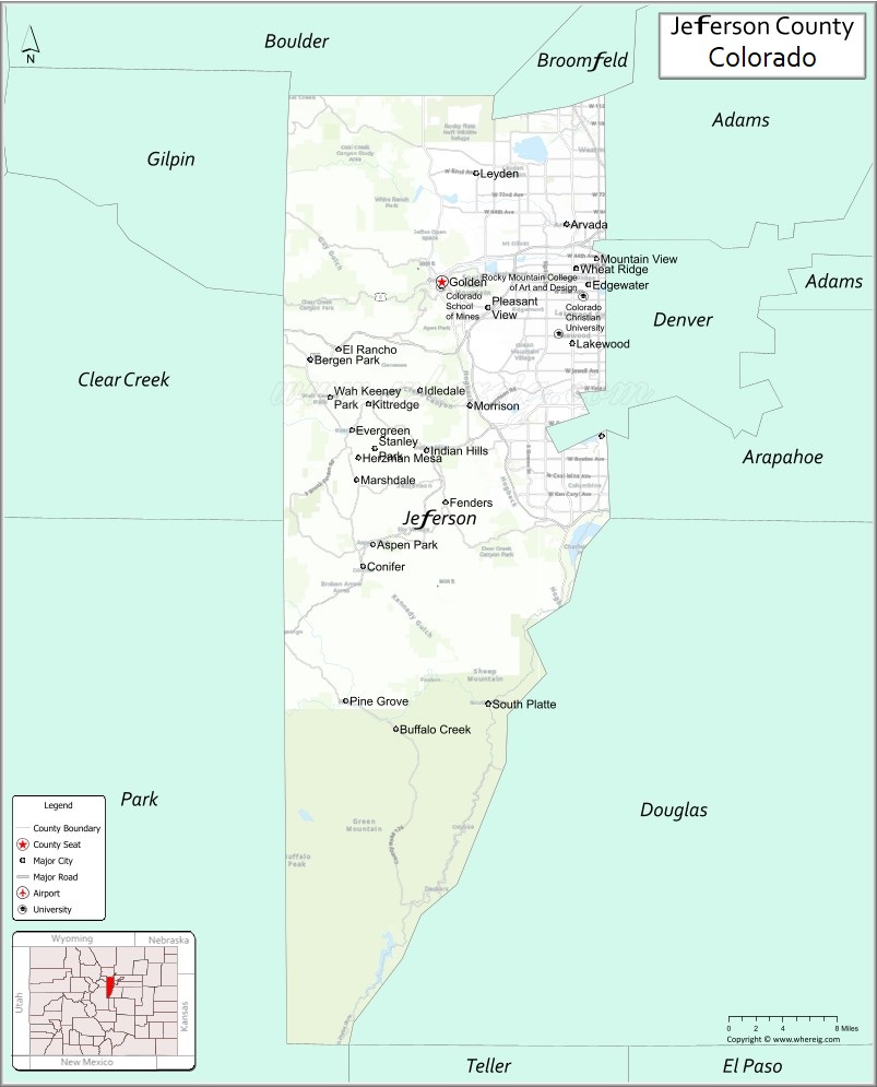
About Jefferson County Map, Colorado: The map showing the county boundary, county seat, major cities, highways, water bodies and neighbouring counties.
Most Viewed Links
Map of Jefferson County, Colorado
Jefferson County is a county located in the U.S. state of Colorado. It's county seat is Golden. As per 2020 census, the population of Jefferson County is 579581 people and population density is square miles. According to the United States Census Bureau, the county has a total area of 772.85 sq mi (2,002 km2). Jefferson County was established on -13938.
Jefferson County Facts
| Continent | North America |
| Country | United States |
| State | Colorado |
| County Seat | Golden |
| Largest City/Town | Lakewood |
| Established | 1861 |
| Total Area | 774 sq mi (2,005 sq km) |
| Land Area | 764 sq mi (1,979 sq km) |
| Water Area | 10 sq mi (26 sq km) |
| Population | 582,910 (Census 2020) |
| Population Density | 762.9 people per sq mi |
| Time Zone | Mountain Time Zone (MST/MDT) |
| Major Highways | Interstate 70, US Highway 6, US Highway 285, State Highway 93, C-470 |
| Major Rivers | South Platte River, Clear Creek |
| Neighboring Counties | Boulder County, Gilpin County, Clear Creek County, Park County, Douglas County, Denver County, Adams County, Arapahoe County |
| Famous For | Red Rocks Amphitheatre, Golden, mountain parks, breweries, and Denver suburbs |
| Top Attractions | Red Rocks Park, Lookout Mountain, Coors Brewery, Dinosaur Ridge |
| Official Website | Official Website |
About Jefferson County, Colorado
Jefferson County is located in north-central Colorado in the United States and was established in 1861 as one of the original counties of the Colorado Territory. The county seat is Golden, while Lakewood is the largest city. The county is known for mountain parks, outdoor recreation, historic landmarks, suburban communities, and attractions near the Denver metropolitan area.
Cities and Towns in Jefferson County, Colorado
| City/Town | Population (Census 2020) | Latitude & Longitude |
|---|---|---|
| Golden (county seat) | 20,399 | 39.7555°N, 105.2211°W |
| Lakewood | 155,984 | 39.7047°N, 105.0814°W |
| Arvada | 124,402 | 39.8028°N, 105.0875°W |
| Wheat Ridge | 32,284 | 39.7661°N, 105.0772°W |
| Littleton (partly) | 45,652 | 39.6133°N, 105.0166°W |
| Edgewater | 5,170 | 39.7533°N, 105.0647°W |
| Evergreen (CDP) | 9,307 | 39.6333°N, 105.3172°W |
| Conifer (CDP) | 8,355 | 39.5197°N, 105.3050°W |
| Morrison | 430 | 39.6539°N, 105.1911°W |
| Genesee (CDP) | 3,609 | 39.7014°N, 105.2722°W |
Golf Courses in Jefferson County, Colorado
| Golf Course | Location | Latitude & Longitude |
|---|---|---|
| Fossil Trace Golf Club | Golden | 39.7406°N, 105.2158°W |
| Fox Hollow Golf Course | Lakewood | 39.6378°N, 105.1453°W |
| Evergreen Golf Course | Evergreen | 39.6436°N, 105.3214°W |
| Indian Tree Golf Club | Arvada | 39.8303°N, 105.1069°W |
| The Club at Rolling Hills | Golden | 39.7011°N, 105.1928°W |
Roads and Highways in Jefferson County, Colorado
Major highways connect the county to Denver, the Rocky Mountains, and western Colorado.
- Interstate 70 - major interstate connecting Denver with mountain resorts and western Colorado
- US Highway 6 - route linking Golden with Clear Creek Canyon and Denver metro areas
- US Highway 285 - major southwest route through Conifer toward the mountains and southern Colorado
- Colorado State Highway 93 - scenic highway connecting Golden with Boulder
- C-470 - beltway highway serving southern and western Denver suburbs
Neighboring Counties of Jefferson County
- Boulder County (north)
- Gilpin County (northwest)
- Clear Creek County (west)
- Park County (southwest)
- Douglas County (south)
- Arapahoe County (southeast)
- Denver County (east)
- Adams County (northeast)
Top Attractions in Jefferson County, Colorado
The county offers a mix of natural, historical, and recreational attractions.
- Red Rocks Park and Amphitheatre - world-famous outdoor concert venue and hiking destination
- Lookout Mountain - scenic overlook and historic Buffalo Bill Museum site
- Coors Brewery Tour - famous brewery attraction in Golden
- Dinosaur Ridge - paleontology site featuring dinosaur tracks and fossils
- Golden Gate Canyon State Park - mountain recreation area with hiking and camping
- Mount Falcon Park - scenic park with hiking trails and Denver skyline views
- Clear Creek Canyon Park - canyon recreation area for climbing, biking, and rafting
- Colorado Railroad Museum - railroad history museum in Golden
- Apex Park - mountain biking and hiking trail network
- Bear Creek Lake Park - recreation area with lakes, trails, and camping
- Evergreen Lake - mountain lake popular for kayaking, skating, and fishing
- Buffalo Bill Museum and Grave - historic museum and gravesite atop Lookout Mountain
Distance from Jefferson County to Nearby Cities
The following distances are measured by road (driving).
- Golden to Denver (Denver County), Colorado - 15 mi (24 km)
- Golden to Boulder (Boulder County), Colorado - 22 mi (35 km)
- Golden to Colorado Springs (El Paso County), Colorado - 78 mi (126 km)
- Golden to Fort Collins (Larimer County), Colorado - 68 mi (109 km)
- Golden to Idaho Springs (Clear Creek County), Colorado - 32 mi (51 km)
- Golden to Breckenridge (Summit County), Colorado - 78 mi (126 km)
- Golden to Vail (Eagle County), Colorado - 97 mi (156 km)
- Golden to Estes Park (Larimer County), Colorado - 57 mi (92 km)
- Golden to Grand Junction (Mesa County), Colorado - 247 mi (398 km)
- Golden to Pueblo (Pueblo County), Colorado - 120 mi (193 km)
- Golden to Aspen (Pitkin County), Colorado - 199 mi (320 km)
- Golden to Moab (Grand County), Utah - 356 mi (573 km)
FAQs about Jefferson County
Jefferson County is located in north-central Colorado along the western edge of the Denver metropolitan area in the United States.
The population of Jefferson County was 582,910 according to the Census 2020.
Jefferson County is known for Red Rocks Amphitheatre, Golden, mountain parks, breweries, and outdoor recreation.
The county is served by Interstate 70, US Highway 6, US Highway 285, Colorado State Highway 93, and C-470.
Popular attractions include Red Rocks Park, Lookout Mountain, Dinosaur Ridge, and the Coors Brewery in Golden.
References
- QuickFacts - U.S. Census Bureau
- United States Census Bureau
- United States Geological Survey (USGS)
- National Geodetic Survey
- Official Website
- Adams County Map
- Alamosa County Map
- Arapahoe County Map
- Archuleta County Map
- Baca County Map
- Bent County Map
- Boulder County Map
- Broomfield County Map
- Chaffee County Map
- Cheyenne County Map
- Clear Creek County Map
- Conejos County Map
- Costilla County Map
- Crowley County Map
- Custer County Map
- Delta County Map
- Denver County Map
- Dolores County Map
- Douglas County Map
- Eagle County Map
- Elbert County Map
- El Paso County Map
- Fremont County Map
- Garfield County Map
- Gilpin County Map
- Grand County Map
- Gunnison County Map
- Hinsdale County Map
- Huerfano County Map
- Jackson County Map
- Jefferson County Map
- Kiowa County Map
- Kit Carson County Map
- Lake County Map
- La Plata County Map
- Larimer County Map
- Las Animas County Map
- Lincoln County Map
- Logan County Map
- Mesa County Map
- Mineral County Map
- Moffat County Map
- Montezuma County Map
- Montrose County Map
- Morgan County Map
- Otero County Map
- Ouray County Map
- Park County Map
- Phillips County Map
- Pitkin County Map
- Prowers County Map
- Pueblo County Map
- Rio Blanco County Map
- Rio Grande County Map
- Routt County Map
- Saguache County Map
- San Juan County Map
- San Miguel County Map
- Sedgwick County Map
- Summit County Map
- Teller County Map
- Washington County Map
- Weld County Map
- Yuma County Map
- Alabama Counties
- Alaska boroughs
- Arizona Counties
- Arkansas Counties
- California County Map
- Colorado Counties
- Connecticut Counties
- Delaware Counties
- Florida County Map
- Georgia County Map
- Hawaii Counties
- Idaho Counties
- Illinois Counties
- Indiana Counties
- Iowa Counties
- Kansas Counties
- Kentucky Counties
- Louisiana Counties
- Maine Counties
- Maryland Counties
- Massachusetts Counties
- Michigan County Map
- Minnesota Counties
- Mississippi Counties
- Missouri Counties
- Montana Counties
- Nebraska Counties
- Nevada Counties
- New York Counties
- New Hampshire Counties
- New Jersey Counties
- New Mexico Counties
- North Carolina Counties
- North Dakota Counties
- Ohio County Map
- Oklahoma Counties
- Oregon Counties
- Pennsylvania Counties
- Rhode Island Counties
- South Carolina Counties
- South Dakota Counties
- Map of Tennessee
- Texas County Map
- Utah Counties
- Vermont Counties
- Virginia Counties
- Washington Counties
- West Virginia Counties
- Wisconsin Counties
- Wyoming Counties