Map of Ouray County - Ouray County is a county located in the U.S. state of Colorado. Ouray County Map showing cities, highways, important places and water bodies. Get Where is Ouray County located in the map, major cities in Ouray county, population, areas, and places of interest.
Map of Ouray County, Colorado
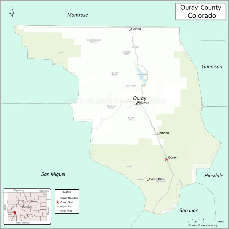
About Ouray County Map, Colorado: The map showing the county boundary, county seat, major cities, highways, water bodies and neighbouring counties.
Most Viewed Links
Map of Ouray County, Colorado
Ouray County is a county located in the U.S. state of Colorado. It's county seat is Ouray. As per 2020 census, the population of Ouray County is 5035 people and population density is square miles. According to the United States Census Bureau, the county has a total area of 542.30 sq mi (1,405 km2). Ouray County was established on -8381.
Ouray County Facts
| Continent | North America |
| Country | United States |
| State | Colorado |
| County Seat | Ouray |
| Largest City/Town | Ouray |
| Established | 1877 |
| Total Area | 542 sq mi (1,404 sq km) |
| Land Area | 542 sq mi (1,404 sq km) |
| Water Area | 0.2 sq mi (0.5 sq km) |
| Population | 4,564 (Census 2020) |
| Population Density | 8.4 people per sq mi |
| Time Zone | Mountain Time Zone (MST/MDT) |
| Major Highways | US Highway 550, State Highway 62 |
| Major Rivers | Uncompahgre River |
| Neighboring Counties | Montrose County, San Miguel County, Hinsdale County, San Juan County |
| Famous For | Ouray hot springs, San Juan Mountains, scenic drives, and alpine recreation |
| Top Attractions | Ouray Hot Springs, Million Dollar Highway, Box Canyon Falls, Yankee Boy Basin |
| Official Website | Official Website |
About Ouray County, Colorado
Ouray County is located in southwestern Colorado in the United States and was established in 1877. The county seat and largest town is Ouray. The county is known for dramatic alpine scenery, hot springs, mountain passes, mining history, and outdoor recreation in the San Juan Mountains.
Cities and Towns in Ouray County, Colorado
| City/Town | Population (Census 2020) | Latitude & Longitude |
|---|---|---|
| Ouray (county seat) | 898 | 38.0228°N, 107.6714°W |
| Ridgway | 1,183 | 38.1528°N, 107.7556°W |
| Colona (CDP) | 500 | 38.3306°N, 107.7756°W |
| Portland (historic site) | Historic mining area | 38.0408°N, 107.6761°W |
| Ironton (ghost town) | Historic site | 37.9322°N, 107.6528°W |
| Camp Bird Mine area | Historic mining district | 38.0106°N, 107.6931°W |
| Dallas Divide area | Scenic mountain region | 38.1861°N, 107.8069°W |
| Yankee Boy Basin area | Alpine recreation area | 37.9906°N, 107.7392°W |
Golf Courses in Ouray County, Colorado
| Golf Course | Location | Latitude & Longitude |
|---|---|---|
| Divide Ranch & Club | Ridgway | 38.1517°N, 107.7581°W |
| Cobble Creek Golf Community | Montrose nearby | 38.4403°N, 107.8597°W |
| The Bridges Golf & Country Club | Montrose nearby | 38.4517°N, 107.8636°W |
Roads and Highways in Ouray County, Colorado
Major highways connect the county to scenic mountain passes and southwestern Colorado communities.
- US Highway 550 - famous Million Dollar Highway route connecting Ouray with Silverton and Montrose
- Colorado State Highway 62 - scenic route linking Ridgway with Telluride and western mountain regions
Neighboring Counties of Ouray County
- Montrose County (north)
- San Miguel County (west)
- Hinsdale County (east)
- San Juan County (south)
Top Attractions in Ouray County, Colorado
The county offers a mix of scenic, recreational, and historical attractions.
- Ouray Hot Springs Pool - geothermal hot springs complex surrounded by mountain scenery
- Million Dollar Highway - scenic mountain drive featuring dramatic cliffs and alpine views
- Box Canyon Falls Park - waterfall attraction located within a narrow canyon in Ouray
- Yankee Boy Basin - alpine basin known for wildflowers, jeep roads, and hiking trails
- Ridgway State Park - boating, camping, fishing, and recreation area
- Ouray Ice Park - internationally known ice climbing destination during winter
- Historic Downtown Ouray - Victorian architecture, shops, and restaurants
- Alpine Loop Scenic Byway nearby - off-road and mountain driving route through former mining districts
- Camp Bird Mine historic area - preserved mining heritage and mountain scenery
- Sneffels Range recreation areas - hiking and mountaineering destination
- Uncompahgre Gorge and River trails - scenic walking and outdoor recreation areas
- Dallas Divide viewpoints - panoramic views of Mount Sneffels and surrounding mountains
Distance from Ouray County to Nearby Cities
The following distances are measured by road (driving).
- Ouray to Montrose (Montrose County), Colorado - 36 mi (58 km)
- Ouray to Telluride (San Miguel County), Colorado - 50 mi (80 km)
- Ouray to Silverton (San Juan County), Colorado - 24 mi (39 km)
- Ouray to Durango (La Plata County), Colorado - 71 mi (114 km)
- Ouray to Grand Junction (Mesa County), Colorado - 101 mi (163 km)
- Ouray to Gunnison (Gunnison County), Colorado - 110 mi (177 km)
- Ouray to Moab (Grand County), Utah - 132 mi (212 km)
- Ouray to Aspen (Pitkin County), Colorado - 151 mi (243 km)
- Ouray to Denver (Denver County), Colorado - 327 mi (526 km)
- Ouray to Colorado Springs (El Paso County), Colorado - 378 mi (608 km)
- Ouray to Salt Lake City (Salt Lake County), Utah - 366 mi (589 km)
- Ouray to Santa Fe (Santa Fe County), New Mexico - 313 mi (504 km)
FAQs about Ouray County
Ouray County is located in southwestern Colorado within the San Juan Mountains region of the United States.
The population of Ouray County was 4,564 according to the Census 2020.
Ouray County is known for alpine scenery, hot springs, mountain passes, and outdoor recreation.
The county is served by US Highway 550 and Colorado State Highway 62.
Popular attractions include Ouray Hot Springs, the Million Dollar Highway, Box Canyon Falls, and Yankee Boy Basin.
References
- QuickFacts - U.S. Census Bureau
- United States Census Bureau
- United States Geological Survey (USGS)
- National Geodetic Survey
- Official Website
- Adams County Map
- Alamosa County Map
- Arapahoe County Map
- Archuleta County Map
- Baca County Map
- Bent County Map
- Boulder County Map
- Broomfield County Map
- Chaffee County Map
- Cheyenne County Map
- Clear Creek County Map
- Conejos County Map
- Costilla County Map
- Crowley County Map
- Custer County Map
- Delta County Map
- Denver County Map
- Dolores County Map
- Douglas County Map
- Eagle County Map
- Elbert County Map
- El Paso County Map
- Fremont County Map
- Garfield County Map
- Gilpin County Map
- Grand County Map
- Gunnison County Map
- Hinsdale County Map
- Huerfano County Map
- Jackson County Map
- Jefferson County Map
- Kiowa County Map
- Kit Carson County Map
- Lake County Map
- La Plata County Map
- Larimer County Map
- Las Animas County Map
- Lincoln County Map
- Logan County Map
- Mesa County Map
- Mineral County Map
- Moffat County Map
- Montezuma County Map
- Montrose County Map
- Morgan County Map
- Otero County Map
- Ouray County Map
- Park County Map
- Phillips County Map
- Pitkin County Map
- Prowers County Map
- Pueblo County Map
- Rio Blanco County Map
- Rio Grande County Map
- Routt County Map
- Saguache County Map
- San Juan County Map
- San Miguel County Map
- Sedgwick County Map
- Summit County Map
- Teller County Map
- Washington County Map
- Weld County Map
- Yuma County Map
- Alabama Counties
- Alaska boroughs
- Arizona Counties
- Arkansas Counties
- California County Map
- Colorado Counties
- Connecticut Counties
- Delaware Counties
- Florida County Map
- Georgia County Map
- Hawaii Counties
- Idaho Counties
- Illinois Counties
- Indiana Counties
- Iowa Counties
- Kansas Counties
- Kentucky Counties
- Louisiana Counties
- Maine Counties
- Maryland Counties
- Massachusetts Counties
- Michigan County Map
- Minnesota Counties
- Mississippi Counties
- Missouri Counties
- Montana Counties
- Nebraska Counties
- Nevada Counties
- New York Counties
- New Hampshire Counties
- New Jersey Counties
- New Mexico Counties
- North Carolina Counties
- North Dakota Counties
- Ohio County Map
- Oklahoma Counties
- Oregon Counties
- Pennsylvania Counties
- Rhode Island Counties
- South Carolina Counties
- South Dakota Counties
- Map of Tennessee
- Texas County Map
- Utah Counties
- Vermont Counties
- Virginia Counties
- Washington Counties
- West Virginia Counties
- Wisconsin Counties
- Wyoming Counties