Map of Dolores County - Dolores County is a county located in the U.S. state of Colorado. Dolores County Map showing cities, highways, important places and water bodies. Get Where is Dolores County located in the map, major cities in Dolores county, population, areas, and places of interest.
Map of Dolores County, Colorado
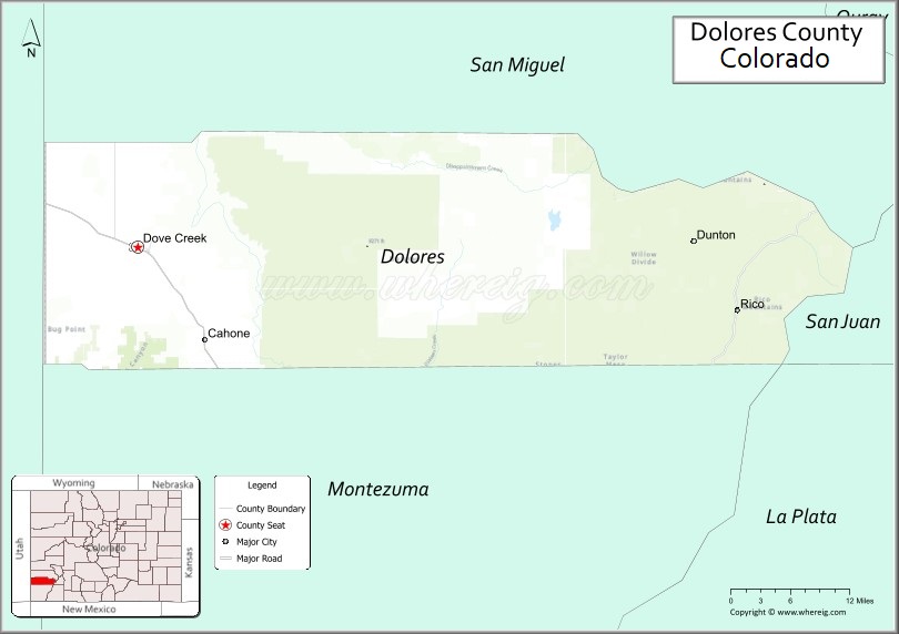
About Dolores County Map, Colorado: The map showing the county boundary, county seat, major cities, highways, water bodies and neighbouring counties.
Most Viewed Links
Map of Dolores County, Colorado
Dolores County is a county located in the U.S. state of Colorado. It's county seat is Dove Creek. As per 2020 census, the population of Dolores County is 2397 people and population density is square miles. According to the United States Census Bureau, the county has a total area of 1,076.93 sq mi (2,789 km2). Dolores County was established on -6875.
Dolores County Facts
| Continent | North America |
| Country | United States |
| State | Colorado |
| County Seat | Dove Creek |
| Largest City/Town | Dove Creek |
| Established | 1881 |
| Total Area | 1,067 sq mi (2,763 sq km) |
| Land Area | 1,061 sq mi (2,748 sq km) |
| Water Area | 6 sq mi (16 sq km) |
| Population | 2,288 (Census 2020) |
| Population Density | 2.2 people per sq mi |
| Time Zone | Mountain Time Zone (MST/MDT) |
| Major Highways | US Highway 491, State Highway 145 |
| Major Rivers | Dolores River, San Miguel River watershed |
| Neighboring Counties | Montezuma County, San Miguel County, Montrose County, San Juan County (Utah) |
| Famous For | Canyons, archaeological sites, bean farming, and scenic southwestern Colorado landscapes |
| Top Attractions | Canyons of the Ancients nearby, Dolores River, Lone Mesa State Park, San Juan National Forest |
| Official Website | Official Website |
About Dolores County, Colorado
Dolores County is located in southwestern Colorado in the United States and was established in 1881. The county seat and largest town is Dove Creek. The county is known for its canyon landscapes, Native American archaeological history, outdoor recreation, farming, and remote high-desert scenery.
Cities and Towns in Dolores County, Colorado
| City/Town | Population (Census 2020) | Latitude & Longitude |
|---|---|---|
| Dove Creek (county seat) | 635 | 37.7661°N, 108.9050°W |
| Rico | 288 | 37.6936°N, 108.0328°W |
| Dunton (ghost town area) | Historic site | 37.8097°N, 108.1017°W |
| Cahone (CDP) | 22 | 37.6644°N, 108.7942°W |
| Egnar (CDP) | 31 | 37.9258°N, 108.7153°W |
Golf Courses in Dolores County, Colorado
| Golf Course | Location | Latitude & Longitude |
|---|---|---|
| Dove Creek Recreation Golf Area | Dove Creek | 37.7669°N, 108.9042°W |
| Rico Mountain Recreation Area | Rico | 37.6928°N, 108.0319°W |
Roads and Highways in Dolores County, Colorado
Major highways connect the county to southwestern Colorado communities and neighboring Utah regions.
- US Highway 491 - major north-south route connecting Dove Creek with Cortez and Monticello, Utah
- Colorado State Highway 145 - scenic highway linking Rico with Telluride and Dolores
Neighboring Counties of Dolores County
- Montezuma County (south)
- San Miguel County (north)
- Montrose County (northeast)
- San Juan County, Utah (west)
Top Attractions in Dolores County, Colorado
The county offers a mix of natural and historical attractions.
- Dolores River Canyon - scenic canyon area popular for rafting, fishing, and hiking
- Lone Mesa State Park - remote park area with camping, wildlife viewing, and hiking trails
- Canyons of the Ancients nearby - archaeological region with ancient Puebloan sites and ruins
- Rico Historic District - former mining town with preserved mountain architecture
- San Juan National Forest - forest recreation area with camping and mountain trails
- Dunton Hot Springs - historic resort area with geothermal springs and restored cabins
- Groundhog Reservoir - reservoir recreation area for fishing, boating, and camping
- Disappointment Valley - scenic high desert valley with dramatic landscapes
- Boggy Draw Recreation Area nearby - mountain biking and hiking trail system
- Dolores County Historical Society Museum - local history exhibits and pioneer artifacts
- McPhee Recreation Areas nearby - outdoor recreation around Colorado's large reservoir system
- Cahone Pioneer Sites - historic rural settlements and ranching landscapes
Distance from Dolores County to Nearby Cities
The following distances are measured by road (driving).
- Dove Creek to Cortez (Montezuma County), Colorado - 23 mi (37 km)
- Dove Creek to Telluride (San Miguel County), Colorado - 95 mi (153 km)
- Dove Creek to Durango (La Plata County), Colorado - 84 mi (135 km)
- Dove Creek to Montrose (Montrose County), Colorado - 116 mi (187 km)
- Dove Creek to Grand Junction (Mesa County), Colorado - 145 mi (233 km)
- Dove Creek to Moab (Grand County), Utah - 113 mi (182 km)
- Dove Creek to Monticello (San Juan County), Utah - 31 mi (50 km)
- Dove Creek to Pagosa Springs (Archuleta County), Colorado - 126 mi (203 km)
- Dove Creek to Farmington (San Juan County), New Mexico - 97 mi (156 km)
- Dove Creek to Denver (Denver County), Colorado - 390 mi (628 km)
- Dove Creek to Colorado Springs (El Paso County), Colorado - 334 mi (538 km)
- Dove Creek to Cortez Municipal Airport - 25 mi (40 km)
FAQs about Dolores County
Dolores County is located in southwestern Colorado near the Utah border in the United States.
The population of Dolores County was 2,288 according to the Census 2020.
Dolores County is known for canyon scenery, archaeological history, bean farming, and outdoor recreation.
The county is served by US Highway 491 and Colorado State Highway 145.
Dolores County has recreation golf and outdoor leisure areas serving communities such as Dove Creek and Rico.
References
- QuickFacts - U.S. Census Bureau
- United States Census Bureau
- United States Geological Survey (USGS)
- National Geodetic Survey
- Official Website
- Adams County Map
- Alamosa County Map
- Arapahoe County Map
- Archuleta County Map
- Baca County Map
- Bent County Map
- Boulder County Map
- Broomfield County Map
- Chaffee County Map
- Cheyenne County Map
- Clear Creek County Map
- Conejos County Map
- Costilla County Map
- Crowley County Map
- Custer County Map
- Delta County Map
- Denver County Map
- Dolores County Map
- Douglas County Map
- Eagle County Map
- Elbert County Map
- El Paso County Map
- Fremont County Map
- Garfield County Map
- Gilpin County Map
- Grand County Map
- Gunnison County Map
- Hinsdale County Map
- Huerfano County Map
- Jackson County Map
- Jefferson County Map
- Kiowa County Map
- Kit Carson County Map
- Lake County Map
- La Plata County Map
- Larimer County Map
- Las Animas County Map
- Lincoln County Map
- Logan County Map
- Mesa County Map
- Mineral County Map
- Moffat County Map
- Montezuma County Map
- Montrose County Map
- Morgan County Map
- Otero County Map
- Ouray County Map
- Park County Map
- Phillips County Map
- Pitkin County Map
- Prowers County Map
- Pueblo County Map
- Rio Blanco County Map
- Rio Grande County Map
- Routt County Map
- Saguache County Map
- San Juan County Map
- San Miguel County Map
- Sedgwick County Map
- Summit County Map
- Teller County Map
- Washington County Map
- Weld County Map
- Yuma County Map
- Alabama Counties
- Alaska boroughs
- Arizona Counties
- Arkansas Counties
- California County Map
- Colorado Counties
- Connecticut Counties
- Delaware Counties
- Florida County Map
- Georgia County Map
- Hawaii Counties
- Idaho Counties
- Illinois Counties
- Indiana Counties
- Iowa Counties
- Kansas Counties
- Kentucky Counties
- Louisiana Counties
- Maine Counties
- Maryland Counties
- Massachusetts Counties
- Michigan County Map
- Minnesota Counties
- Mississippi Counties
- Missouri Counties
- Montana Counties
- Nebraska Counties
- Nevada Counties
- New York Counties
- New Hampshire Counties
- New Jersey Counties
- New Mexico Counties
- North Carolina Counties
- North Dakota Counties
- Ohio County Map
- Oklahoma Counties
- Oregon Counties
- Pennsylvania Counties
- Rhode Island Counties
- South Carolina Counties
- South Dakota Counties
- Map of Tennessee
- Texas County Map
- Utah Counties
- Vermont Counties
- Virginia Counties
- Washington Counties
- West Virginia Counties
- Wisconsin Counties
- Wyoming Counties