Map of Phillips County - Phillips County is a county located in the U.S. state of Colorado. Phillips County Map showing cities, highways, important places and water bodies. Get Where is Phillips County located in the map, major cities in Phillips county, population, areas, and places of interest.
Map of Phillips County, Colorado
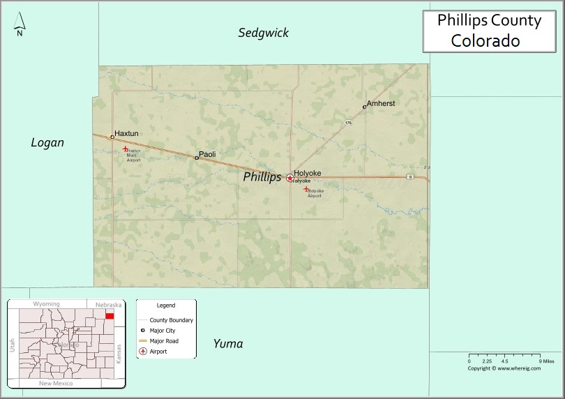
About Phillips County Map, Colorado: The map showing the county boundary, county seat, major cities, highways, water bodies and neighbouring counties.
Most Viewed Links
Map of Phillips County, Colorado
Phillips County is a county located in the U.S. state of Colorado. It's county seat is Holyoke. As per 2020 census, the population of Phillips County is 4512 people and population density is square miles. According to the United States Census Bureau, the county has a total area of 688.30 sq mi (1,783 km2). Phillips County was established on -3930.
Phillips County Facts
| Continent | North America |
| Country | United States |
| State | Colorado |
| County Seat | Holyoke |
| Largest City/Town | Holyoke |
| Established | 1889 |
| Total Area | 688 sq mi (1,782 sq km) |
| Land Area | 688 sq mi (1,782 sq km) |
| Water Area | 0.2 sq mi (0.5 sq km) |
| Population | 4,530 (Census 2020) |
| Population Density | 6.6 people per sq mi |
| Time Zone | Mountain Time Zone (MST/MDT) |
| Major Highways | US Highway 6, US Highway 385, State Highway 23 |
| Major Rivers | Frenchman Creek watershed, South Platte River basin |
| Neighboring Counties | Sedgwick County, Logan County, Yuma County, Perkins County (NE), Chase County (NE) |
| Famous For | Agriculture, High Plains scenery, Holyoke, and northeastern Colorado farming communities |
| Top Attractions | Holyoke Heritage Center, High Plains prairie landscapes, local fairs, birdwatching areas |
| Official Website | Official Website |
About Phillips County, Colorado
Phillips County is located in northeastern Colorado in the United States and was established in 1889. The county seat and largest city is Holyoke. The county is known for agriculture, ranching, prairie landscapes, and small High Plains communities near the Nebraska border.
Cities and Towns in Phillips County, Colorado
| City/Town | Population (Census 2020) | Latitude & Longitude |
|---|---|---|
| Holyoke (county seat) | 2,346 | 40.5825°N, 102.3021°W |
| Haxtun | 946 | 40.6281°N, 102.6283°W |
| Paoli | 51 | 40.6128°N, 102.4711°W |
| Amherst | 21 | 40.6828°N, 102.1733°W |
| Venango nearby area | Regional community | 40.7833°N, 102.0333°W |
| Champion nearby region | Rural area | 40.5000°N, 102.0500°W |
| Frenchman Creek area | Prairie region | 40.6200°N, 102.2200°W |
| High Plains farm communities | Regional agricultural area | 40.6000°N, 102.4000°W |
Golf Courses in Phillips County, Colorado
| Golf Course | Location | Latitude & Longitude |
|---|---|---|
| Holyoke Country Club | Holyoke | 40.5822°N, 102.3008°W |
| Riverside Golf Club | Sterling nearby | 40.6297°N, 103.2153°W |
| Indianhead Golf Course | Kimball nearby, Nebraska | 41.2386°N, 103.6647°W |
Roads and Highways in Phillips County, Colorado
Major highways connect the county to northeastern Colorado, Nebraska, and regional agricultural communities.
- US Highway 6 - historic east-west highway crossing northern Phillips County
- US Highway 385 - north-south route linking Holyoke with Nebraska and southeastern Colorado
- Colorado State Highway 23 - regional highway connecting farming communities across northeastern Colorado
Neighboring Counties of Phillips County
- Sedgwick County (east)
- Logan County (west)
- Yuma County (south)
- Perkins County, Nebraska (northwest)
- Chase County, Nebraska (north)
Top Attractions in Phillips County, Colorado
The county offers a mix of prairie, agricultural, and historical attractions.
- Holyoke Heritage Center - museum featuring local history, pioneer artifacts, and agricultural exhibits
- High Plains prairie landscapes - scenic rural drives and open grassland views
- Frenchman Creek recreation areas - wildlife viewing and birdwatching opportunities
- Phillips County Fairgrounds - rodeos, fairs, and community agricultural events
- Historic Downtown Holyoke - local shops, restaurants, and historic architecture
- Haxtun community parks and recreation areas - local outdoor gathering spaces
- Prairie wildlife habitats - birdwatching areas for migratory birds and prairie species
- Regional farming and ranching landscapes - agricultural heritage attractions
- Local grain elevator landmarks - symbols of northeastern Colorado agricultural history
- Small-town festivals and county events - community celebrations and heritage gatherings
- Prairie sunset and dark sky viewing areas - scenic open-space landscapes
- Nebraska border scenic routes - rural highway drives through High Plains terrain
Distance from Phillips County to Nearby Cities
The following distances are measured by road (driving).
- Holyoke to Sterling (Logan County), Colorado - 62 mi (100 km)
- Holyoke to Fort Collins (Larimer County), Colorado - 142 mi (229 km)
- Holyoke to Denver (Denver County), Colorado - 182 mi (293 km)
- Holyoke to North Platte (Lincoln County), Nebraska - 122 mi (196 km)
- Holyoke to McCook (Red Willow County), Nebraska - 76 mi (122 km)
- Holyoke to Cheyenne (Laramie County), Wyoming - 172 mi (277 km)
- Holyoke to Greeley (Weld County), Colorado - 123 mi (198 km)
- Holyoke to Colorado Springs (El Paso County), Colorado - 253 mi (407 km)
- Holyoke to Wichita (Sedgwick County), Kansas - 335 mi (539 km)
- Holyoke to Omaha (Douglas County), Nebraska - 336 mi (541 km)
- Holyoke to Grand Junction (Mesa County), Colorado - 392 mi (631 km)
- Holyoke to Amarillo (Potter County), Texas - 392 mi (631 km)
FAQs about Phillips County
Phillips County is located in northeastern Colorado near the Nebraska border in the United States.
The population of Phillips County was 4,530 according to the Census 2020.
Phillips County is known for agriculture, prairie landscapes, ranching, and the community of Holyoke.
The county is served by US Highway 6, US Highway 385, and Colorado State Highway 23.
Popular attractions include the Holyoke Heritage Center, prairie scenic drives, local fairs, and wildlife viewing areas.
References
- QuickFacts - U.S. Census Bureau
- United States Census Bureau
- United States Geological Survey (USGS)
- National Geodetic Survey
- Official Website
- Adams County Map
- Alamosa County Map
- Arapahoe County Map
- Archuleta County Map
- Baca County Map
- Bent County Map
- Boulder County Map
- Broomfield County Map
- Chaffee County Map
- Cheyenne County Map
- Clear Creek County Map
- Conejos County Map
- Costilla County Map
- Crowley County Map
- Custer County Map
- Delta County Map
- Denver County Map
- Dolores County Map
- Douglas County Map
- Eagle County Map
- Elbert County Map
- El Paso County Map
- Fremont County Map
- Garfield County Map
- Gilpin County Map
- Grand County Map
- Gunnison County Map
- Hinsdale County Map
- Huerfano County Map
- Jackson County Map
- Jefferson County Map
- Kiowa County Map
- Kit Carson County Map
- Lake County Map
- La Plata County Map
- Larimer County Map
- Las Animas County Map
- Lincoln County Map
- Logan County Map
- Mesa County Map
- Mineral County Map
- Moffat County Map
- Montezuma County Map
- Montrose County Map
- Morgan County Map
- Otero County Map
- Ouray County Map
- Park County Map
- Phillips County Map
- Pitkin County Map
- Prowers County Map
- Pueblo County Map
- Rio Blanco County Map
- Rio Grande County Map
- Routt County Map
- Saguache County Map
- San Juan County Map
- San Miguel County Map
- Sedgwick County Map
- Summit County Map
- Teller County Map
- Washington County Map
- Weld County Map
- Yuma County Map
- Alabama Counties
- Alaska boroughs
- Arizona Counties
- Arkansas Counties
- California County Map
- Colorado Counties
- Connecticut Counties
- Delaware Counties
- Florida County Map
- Georgia County Map
- Hawaii Counties
- Idaho Counties
- Illinois Counties
- Indiana Counties
- Iowa Counties
- Kansas Counties
- Kentucky Counties
- Louisiana Counties
- Maine Counties
- Maryland Counties
- Massachusetts Counties
- Michigan County Map
- Minnesota Counties
- Mississippi Counties
- Missouri Counties
- Montana Counties
- Nebraska Counties
- Nevada Counties
- New York Counties
- New Hampshire Counties
- New Jersey Counties
- New Mexico Counties
- North Carolina Counties
- North Dakota Counties
- Ohio County Map
- Oklahoma Counties
- Oregon Counties
- Pennsylvania Counties
- Rhode Island Counties
- South Carolina Counties
- South Dakota Counties
- Map of Tennessee
- Texas County Map
- Utah Counties
- Vermont Counties
- Virginia Counties
- Washington Counties
- West Virginia Counties
- Wisconsin Counties
- Wyoming Counties