Map of Lincoln County - Lincoln County is a county located in the U.S. state of Colorado. Lincoln County Map showing cities, highways, important places and water bodies. Get Where is Lincoln County located in the map, major cities in Lincoln county, population, areas, and places of interest.
Map of Lincoln County, Colorado
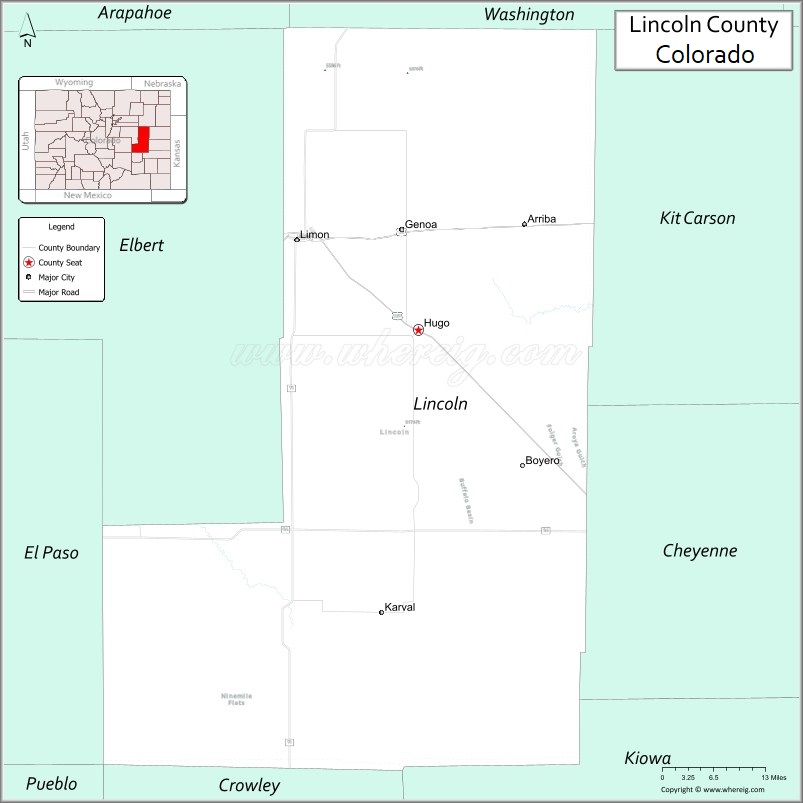
About Lincoln County Map, Colorado: The map showing the county boundary, county seat, major cities, highways, water bodies and neighbouring counties.
Most Viewed Links
Map of Lincoln County, Colorado
Lincoln County is a county located in the U.S. state of Colorado. It's county seat is Hugo. As per 2020 census, the population of Lincoln County is 5688 people and population density is square miles. According to the United States Census Bureau, the county has a total area of 2,585.21 sq mi (6,696 km2). Lincoln County was established on -3915.
Lincoln County Facts
| Continent | North America |
| Country | United States |
| State | Colorado |
| County Seat | Hugo |
| Largest City/Town | Limon |
| Established | 1889 |
| Total Area | 2,586 sq mi (6,698 sq km) |
| Land Area | 2,586 sq mi (6,698 sq km) |
| Water Area | 0.3 sq mi (0.8 sq km) |
| Population | 5,675 (Census 2020) |
| Population Density | 2.2 people per sq mi |
| Time Zone | Mountain Time Zone (MST/MDT) |
| Major Highways | Interstate 70, US Highway 24, US Highway 40, State Highway 71 |
| Major Rivers | Republican River watershed, Big Sandy Creek |
| Neighboring Counties | Washington County, Kit Carson County, Cheyenne County, Kiowa County, Crowley County, Elbert County |
| Famous For | High Plains landscapes, ranching, farming, railroads, and prairie communities |
| Top Attractions | Limon Heritage Museum, Hugo Historic District, prairie scenery, railroad history |
| Official Website | Official Website |
About Lincoln County, Colorado
Lincoln County is located in east-central Colorado in the United States and was established in 1889. The county seat is Hugo, while Limon is the largest town. The county is known for ranching, agriculture, prairie landscapes, railroad history, and transportation routes crossing eastern Colorado.
Cities and Towns in Lincoln County, Colorado
| City/Town | Population (Census 2020) | Latitude & Longitude |
|---|---|---|
| Hugo (county seat) | 730 | 39.1367°N, 103.4717°W |
| Limon | 1,880 | 39.2639°N, 103.6922°W |
| Arriba | 196 | 39.2853°N, 103.2753°W |
| Genoa | 139 | 39.2786°N, 103.4958°W |
| Karval (CDP) | 27 | 38.7394°N, 103.5389°W |
| Matheson (CDP) | 70 | 39.1736°N, 103.9800°W |
| Joes (community) | Historic area | 39.6519°N, 102.6875°W |
| Wild Horse nearby area | Regional prairie area | 39.3000°N, 103.1500°W |
Golf Courses in Lincoln County, Colorado
| Golf Course | Location | Latitude & Longitude |
|---|---|---|
| Limon Municipal Golf Course | Limon | 39.2653°N, 103.6906°W |
| Hugo Golf Course | Hugo | 39.1369°N, 103.4708°W |
| Burlington Golf Club | Burlington nearby | 39.3097°N, 102.2664°W |
Roads and Highways in Lincoln County, Colorado
Major highways connect the county to Denver, eastern Colorado communities, and interstate travel routes.
- Interstate 70 - major east-west interstate connecting Limon with Denver and Kansas
- US Highway 24 - route linking Limon with Colorado Springs and eastern Colorado plains
- US Highway 40 - historic highway crossing northern Lincoln County
- Colorado State Highway 71 - north-south route connecting Hugo with northeastern and southeastern Colorado
Neighboring Counties of Lincoln County
- Washington County (north)
- Kit Carson County (east)
- Cheyenne County (southeast)
- Kiowa County (south)
- Crowley County (southwest)
- Elbert County (west)
Top Attractions in Lincoln County, Colorado
The county offers a mix of prairie, historical, and cultural attractions.
- Limon Heritage Museum - exhibits on railroad history, agriculture, and prairie life
- Hugo Historic District - preserved buildings and local historical landmarks
- Big Sandy Creek recreation areas - wildlife viewing and prairie scenery
- Lincoln County Fairgrounds - rodeos, fairs, and agricultural events
- Prairie Scenic Drives - wide-open landscapes and rural Colorado views
- Historic Railroad Sites - rail history connected to eastern Colorado development
- Limon Welcome Center and Railroad Park - visitor attraction and transportation history exhibits
- Karval Mountain Plover Area - wildlife habitat known for birdwatching
- Agricultural Heritage Landscapes - ranching and farming scenery across the county
- Old Highway 40 routes - historic travel corridors through the High Plains
- Local Prairie Wildlife Areas - habitat for pronghorn, deer, and migratory birds
- Dark Sky Viewing Areas - remote plains locations ideal for stargazing
Distance from Lincoln County to Nearby Cities
The following distances are measured by road (driving).
- Limon to Denver (Denver County), Colorado - 88 mi (142 km)
- Limon to Colorado Springs (El Paso County), Colorado - 74 mi (119 km)
- Limon to Burlington (Kit Carson County), Colorado - 72 mi (116 km)
- Limon to Hugo (Lincoln County), Colorado - 13 mi (21 km)
- Limon to Pueblo (Pueblo County), Colorado - 119 mi (191 km)
- Limon to Fort Collins (Larimer County), Colorado - 152 mi (245 km)
- Limon to Goodland (Sherman County), Kansas - 116 mi (187 km)
- Limon to Colby (Thomas County), Kansas - 133 mi (214 km)
- Limon to Salina (Saline County), Kansas - 286 mi (460 km)
- Limon to Amarillo (Potter County), Texas - 312 mi (502 km)
- Limon to Wichita (Sedgwick County), Kansas - 336 mi (541 km)
- Limon to Grand Junction (Mesa County), Colorado - 337 mi (542 km)
FAQs about Lincoln County
Lincoln County is located in east-central Colorado within the High Plains region of the United States.
The population of Lincoln County was 5,675 according to the Census 2020.
Lincoln County is known for ranching, agriculture, prairie landscapes, and historic railroad communities.
The county is served by Interstate 70, US Highway 24, US Highway 40, and Colorado State Highway 71.
Popular attractions include the Limon Heritage Museum, Hugo Historic District, prairie scenic drives, and local railroad history sites.
References
- QuickFacts - U.S. Census Bureau
- United States Census Bureau
- United States Geological Survey (USGS)
- National Geodetic Survey
- Official Website
- Adams County Map
- Alamosa County Map
- Arapahoe County Map
- Archuleta County Map
- Baca County Map
- Bent County Map
- Boulder County Map
- Broomfield County Map
- Chaffee County Map
- Cheyenne County Map
- Clear Creek County Map
- Conejos County Map
- Costilla County Map
- Crowley County Map
- Custer County Map
- Delta County Map
- Denver County Map
- Dolores County Map
- Douglas County Map
- Eagle County Map
- Elbert County Map
- El Paso County Map
- Fremont County Map
- Garfield County Map
- Gilpin County Map
- Grand County Map
- Gunnison County Map
- Hinsdale County Map
- Huerfano County Map
- Jackson County Map
- Jefferson County Map
- Kiowa County Map
- Kit Carson County Map
- Lake County Map
- La Plata County Map
- Larimer County Map
- Las Animas County Map
- Lincoln County Map
- Logan County Map
- Mesa County Map
- Mineral County Map
- Moffat County Map
- Montezuma County Map
- Montrose County Map
- Morgan County Map
- Otero County Map
- Ouray County Map
- Park County Map
- Phillips County Map
- Pitkin County Map
- Prowers County Map
- Pueblo County Map
- Rio Blanco County Map
- Rio Grande County Map
- Routt County Map
- Saguache County Map
- San Juan County Map
- San Miguel County Map
- Sedgwick County Map
- Summit County Map
- Teller County Map
- Washington County Map
- Weld County Map
- Yuma County Map
- Alabama Counties
- Alaska boroughs
- Arizona Counties
- Arkansas Counties
- California County Map
- Colorado Counties
- Connecticut Counties
- Delaware Counties
- Florida County Map
- Georgia County Map
- Hawaii Counties
- Idaho Counties
- Illinois Counties
- Indiana Counties
- Iowa Counties
- Kansas Counties
- Kentucky Counties
- Louisiana Counties
- Maine Counties
- Maryland Counties
- Massachusetts Counties
- Michigan County Map
- Minnesota Counties
- Mississippi Counties
- Missouri Counties
- Montana Counties
- Nebraska Counties
- Nevada Counties
- New York Counties
- New Hampshire Counties
- New Jersey Counties
- New Mexico Counties
- North Carolina Counties
- North Dakota Counties
- Ohio County Map
- Oklahoma Counties
- Oregon Counties
- Pennsylvania Counties
- Rhode Island Counties
- South Carolina Counties
- South Dakota Counties
- Map of Tennessee
- Texas County Map
- Utah Counties
- Vermont Counties
- Virginia Counties
- Washington Counties
- West Virginia Counties
- Wisconsin Counties
- Wyoming Counties