Map of Garfield County - Garfield County is a county located in the U.S. state of Colorado. Garfield County Map showing cities, highways, important places and water bodies. Get Where is Garfield County located in the map, major cities in Garfield county, population, areas, and places of interest.
Map of Garfield County, Colorado
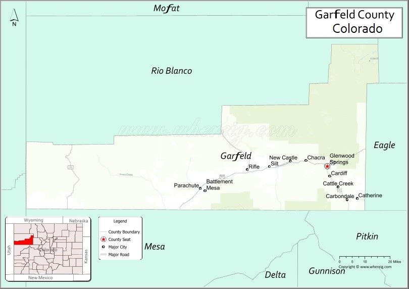
About Garfield County Map, Colorado: The map showing the county boundary, county seat, major cities, highways, water bodies and neighbouring counties.
Most Viewed Links
Map of Garfield County, Colorado
Garfield County is a county located in the U.S. state of Colorado. It's county seat is Glenwood Springs. As per 2020 census, the population of Garfield County is 62161 people and population density is square miles. According to the United States Census Bureau, the county has a total area of 2,958.23 sq mi (7,662 km2). Garfield County was established on -6167.
Garfield County Facts
| Continent | North America |
| Country | United States |
| State | Colorado |
| County Seat | Glenwood Springs |
| Largest City/Town | Rifle |
| Established | 1883 |
| Total Area | 2,956 sq mi (7,656 sq km) |
| Land Area | 2,947 sq mi (7,633 sq km) |
| Water Area | 9 sq mi (23 sq km) |
| Population | 61,685 (Census 2020) |
| Population Density | 20.9 people per sq mi |
| Time Zone | Mountain Time Zone (MST/MDT) |
| Major Highways | Interstate 70, State Highway 82, State Highway 13, State Highway 133 |
| Major Rivers | Colorado River, Roaring Fork River |
| Neighboring Counties | Eagle County, Mesa County, Rio Blanco County, Pitkin County, Gunnison County |
| Famous For | Glenwood Hot Springs, Glenwood Canyon, outdoor recreation, and mountain scenery |
| Top Attractions | Glenwood Hot Springs, Hanging Lake, Glenwood Caverns Adventure Park, Rifle Falls |
| Official Website | Official Website |
About Garfield County, Colorado
Garfield County is located in western Colorado in the United States and was established in 1883. The county seat is Glenwood Springs, while Rifle is the largest city. The county is known for scenic canyons, hot springs, rivers, outdoor recreation, mountain landscapes, and tourism throughout the Colorado River valley.
Cities and Towns in Garfield County, Colorado
| City/Town | Population (Census 2020) | Latitude & Longitude |
|---|---|---|
| Glenwood Springs (county seat) | 9,963 | 39.5505°N, 107.3248°W |
| Rifle | 9,866 | 39.5347°N, 107.7831°W |
| Carbondale | 6,434 | 39.4022°N, 107.2117°W |
| New Castle | 4,974 | 39.5725°N, 107.5367°W |
| Parachute | 1,511 | 39.4511°N, 108.0522°W |
| Silt | 3,537 | 39.5486°N, 107.6564°W |
| Battlement Mesa (CDP) | 4,868 | 39.4417°N, 108.0250°W |
| Mulford (CDP) | 259 | 39.4047°N, 107.1594°W |
| No Name (CDP) | 130 | 39.5733°N, 107.2486°W |
| Cattle Creek (CDP) | 641 | 39.5389°N, 107.2158°W |
Golf Courses in Garfield County, Colorado
| Golf Course | Location | Latitude & Longitude |
|---|---|---|
| Lakota Links Golf Course | New Castle | 39.5783°N, 107.5522°W |
| Glenwood Springs Golf Club | Glenwood Springs | 39.5358°N, 107.3208°W |
| Aspen Glen Club | Carbondale | 39.3947°N, 107.2414°W |
| Rifle Creek Golf Course | Rifle | 39.5328°N, 107.7922°W |
Roads and Highways in Garfield County, Colorado
Major highways connect the county to mountain resorts, western Colorado communities, and scenic recreation areas.
- Interstate 70 - major east-west interstate connecting Glenwood Springs, Rifle, and western Colorado
- Colorado State Highway 82 - scenic highway linking Glenwood Springs with Aspen and the Roaring Fork Valley
- Colorado State Highway 13 - route connecting Rifle with northwestern Colorado and Wyoming
- Colorado State Highway 133 - highway connecting Carbondale with McClure Pass and Delta County
Neighboring Counties of Garfield County
- Eagle County (east)
- Pitkin County (southeast)
- Gunnison County (south)
- Mesa County (west)
- Rio Blanco County (northwest)
Top Attractions in Garfield County, Colorado
The county offers a mix of natural and recreational attractions.
- Glenwood Hot Springs Resort - famous hot springs pool and spa destination
- Hanging Lake - scenic turquoise lake and waterfall hiking destination
- Glenwood Caverns Adventure Park - mountain amusement park and cave tour attraction
- Rifle Falls State Park - waterfalls, caves, and hiking trails near Rifle
- Glenwood Canyon - dramatic canyon scenery along the Colorado River and Interstate 70
- Sunlight Mountain Resort - ski resort offering winter sports and scenic mountain views
- Colorado River Recreation Areas - rafting, kayaking, fishing, and biking opportunities
- Doc Holliday Grave Trail - historic hiking trail leading to the gravesite of Doc Holliday
- Redstone Historic District - historic mining town with preserved architecture and scenic surroundings
- Harvey Gap State Park - reservoir recreation area for boating, fishing, and camping
- Flat Tops Wilderness access areas - wilderness hiking, hunting, and backcountry recreation
- Rifle Mountain Park - internationally known rock climbing destination
Distance from Garfield County to Nearby Cities
The following distances are measured by road (driving).
- Glenwood Springs to Aspen (Pitkin County), Colorado - 41 mi (66 km)
- Glenwood Springs to Eagle (Eagle County), Colorado - 33 mi (53 km)
- Glenwood Springs to Grand Junction (Mesa County), Colorado - 87 mi (140 km)
- Glenwood Springs to Vail (Eagle County), Colorado - 61 mi (98 km)
- Glenwood Springs to Rifle (Garfield County), Colorado - 27 mi (43 km)
- Glenwood Springs to Denver (Denver County), Colorado - 157 mi (253 km)
- Glenwood Springs to Steamboat Springs (Routt County), Colorado - 93 mi (150 km)
- Glenwood Springs to Breckenridge (Summit County), Colorado - 100 mi (161 km)
- Glenwood Springs to Moab (Grand County), Utah - 183 mi (295 km)
- Glenwood Springs to Montrose (Montrose County), Colorado - 123 mi (198 km)
- Glenwood Springs to Durango (La Plata County), Colorado - 224 mi (360 km)
- Glenwood Springs to Colorado Springs (El Paso County), Colorado - 228 mi (367 km)
FAQs about Garfield County
Garfield County is located in western Colorado along the Colorado River valley in the United States.
The population of Garfield County was 61,685 according to the Census 2020.
Garfield County is known for Glenwood Hot Springs, Glenwood Canyon, mountain scenery, and outdoor recreation.
The county is served by Interstate 70, Colorado State Highway 82, Colorado State Highway 13, and Colorado State Highway 133.
Yes, Garfield County has several golf courses including Lakota Links Golf Course, Aspen Glen Club, and Rifle Creek Golf Course.
References
- QuickFacts - U.S. Census Bureau
- United States Census Bureau
- United States Geological Survey (USGS)
- National Geodetic Survey
- Official Website
- Adams County Map
- Alamosa County Map
- Arapahoe County Map
- Archuleta County Map
- Baca County Map
- Bent County Map
- Boulder County Map
- Broomfield County Map
- Chaffee County Map
- Cheyenne County Map
- Clear Creek County Map
- Conejos County Map
- Costilla County Map
- Crowley County Map
- Custer County Map
- Delta County Map
- Denver County Map
- Dolores County Map
- Douglas County Map
- Eagle County Map
- Elbert County Map
- El Paso County Map
- Fremont County Map
- Garfield County Map
- Gilpin County Map
- Grand County Map
- Gunnison County Map
- Hinsdale County Map
- Huerfano County Map
- Jackson County Map
- Jefferson County Map
- Kiowa County Map
- Kit Carson County Map
- Lake County Map
- La Plata County Map
- Larimer County Map
- Las Animas County Map
- Lincoln County Map
- Logan County Map
- Mesa County Map
- Mineral County Map
- Moffat County Map
- Montezuma County Map
- Montrose County Map
- Morgan County Map
- Otero County Map
- Ouray County Map
- Park County Map
- Phillips County Map
- Pitkin County Map
- Prowers County Map
- Pueblo County Map
- Rio Blanco County Map
- Rio Grande County Map
- Routt County Map
- Saguache County Map
- San Juan County Map
- San Miguel County Map
- Sedgwick County Map
- Summit County Map
- Teller County Map
- Washington County Map
- Weld County Map
- Yuma County Map
- Alabama Counties
- Alaska boroughs
- Arizona Counties
- Arkansas Counties
- California County Map
- Colorado Counties
- Connecticut Counties
- Delaware Counties
- Florida County Map
- Georgia County Map
- Hawaii Counties
- Idaho Counties
- Illinois Counties
- Indiana Counties
- Iowa Counties
- Kansas Counties
- Kentucky Counties
- Louisiana Counties
- Maine Counties
- Maryland Counties
- Massachusetts Counties
- Michigan County Map
- Minnesota Counties
- Mississippi Counties
- Missouri Counties
- Montana Counties
- Nebraska Counties
- Nevada Counties
- New York Counties
- New Hampshire Counties
- New Jersey Counties
- New Mexico Counties
- North Carolina Counties
- North Dakota Counties
- Ohio County Map
- Oklahoma Counties
- Oregon Counties
- Pennsylvania Counties
- Rhode Island Counties
- South Carolina Counties
- South Dakota Counties
- Map of Tennessee
- Texas County Map
- Utah Counties
- Vermont Counties
- Virginia Counties
- Washington Counties
- West Virginia Counties
- Wisconsin Counties
- Wyoming Counties