City and County of Denver Map - Denver County is a county located in the U.S. state of Colorado. City and of Denver County Map showing cities, highways, important places and water bodies. Get Where is City and of Denver County located in the map, major cities in City and of Denver county, population, areas, and places of interest.
Map of Denver County, Colorado
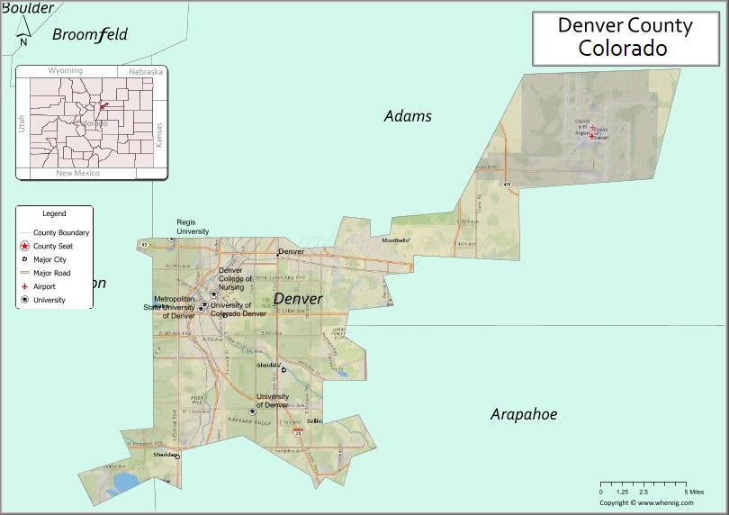
About City and of Denver County Map, Colorado: The map showing the county boundary, county seat, major cities, highways, water bodies and neighbouring counties.
Most Viewed Links
Denver, City and County, Colorado
City and of Denver County is a county located in the U.S. state of Colorado. It's county seat is Denver. As per 2020 census, the population of City and of Denver County is 711463 people and population density is square miles. According to the United States Census Bureau, the county has a total area of 155.66 sq mi (403 km2). City and of Denver County was established on 1066.
Denver City and County Facts
| Continent | North America |
| Country | United States |
| State | Colorado |
| County Seat | Denver |
| Largest City/Town | Denver |
| Established | 1902 (city and county consolidation) |
| Total Area | 155 sq mi (401 sq km) |
| Land Area | 153 sq mi (396 sq km) |
| Water Area | 2 sq mi (5 sq km) |
| Population | 715,522 (Census 2020) |
| Population Density | 4,676 people per sq mi |
| Time Zone | Mountain Time Zone (MST/MDT) |
| Major Highways | Interstate 25, Interstate 70, Interstate 225, US Highway 6, US Highway 36 |
| Major Rivers | South Platte River, Cherry Creek |
| Neighboring Counties | Adams County, Arapahoe County, Jefferson County |
| Famous For | Colorado state capital, Rocky Mountain gateway, sports teams, museums, and downtown culture |
| Top Attractions | Red Rocks nearby, Denver Art Museum, Union Station, Denver Zoo, Coors Field |
| Official Website | Official Website |
About Denver City and County, Colorado
Denver City and County is located in north-central Colorado in the United States and became a consolidated city and county in 1902. Denver serves as the capital and most populous city of Colorado. The city is known for its skyline, outdoor lifestyle, cultural attractions, professional sports teams, and location near the Rocky Mountains.
Cities and Communities in Denver City and County, Colorado
| Community | Population (Census 2020) | Latitude & Longitude |
|---|---|---|
| Denver (county seat) | 715,522 | 39.7392°N, 104.9903°W |
| Capitol Hill | Neighborhood | 39.7347°N, 104.9808°W |
| Cherry Creek | Neighborhood | 39.7208°N, 104.9508°W |
| Five Points | Neighborhood | 39.7597°N, 104.9775°W |
| LoDo (Lower Downtown) | Neighborhood | 39.7527°N, 104.9988°W |
| Highlands | Neighborhood | 39.7625°N, 105.0197°W |
| Washington Park | Neighborhood | 39.7006°N, 104.9717°W |
| Stapleton/Central Park | Neighborhood | 39.7781°N, 104.8811°W |
Golf Courses in Denver City and County, Colorado
| Golf Course | Location | Latitude & Longitude |
|---|---|---|
| City Park Golf Course | Denver | 39.7542°N, 104.9439°W |
| Wellshire Golf Course | Denver | 39.6789°N, 104.9592°W |
| Overland Park Golf Course | Denver | 39.6767°N, 105.0172°W |
| Harvard Gulch Golf Course | Denver | 39.6703°N, 104.9875°W |
| Willis Case Golf Course | Denver | 39.7831°N, 105.0386°W |
Roads and Highways in Denver City and County, Colorado
Denver is a major transportation hub connecting Colorado with the Rocky Mountains, Great Plains, and surrounding states.
- Interstate 25 - north-south interstate connecting Denver with Fort Collins, Colorado Springs, and New Mexico
- Interstate 70 - east-west interstate linking Denver with mountain ski resorts and Kansas
- Interstate 225 - beltway route connecting Denver with Aurora and southeastern suburbs
- US Highway 6 - regional highway serving western and central Denver areas
- US Highway 36 - route connecting Denver with Boulder and northwestern suburbs
Neighboring Counties of Denver City and County
- Adams County (north and east)
- Arapahoe County (south and east)
- Jefferson County (west)
Top Attractions in Denver City and County, Colorado
The city and county offers a mix of cultural, recreational, and entertainment attractions.
- Denver Art Museum - major art museum featuring Western and international collections
- Union Station - historic transportation hub with restaurants, shops, and hotels
- Denver Zoo - large urban zoo with wildlife exhibits and conservation programs
- Coors Field - home stadium of Major League Baseball's Colorado Rockies
- Empower Field at Mile High - stadium hosting Denver Broncos football games and events
- 16th Street Mall - downtown pedestrian shopping and entertainment district
- Denver Botanic Gardens - botanical gardens with themed landscapes and conservatories
- Museum of Nature and Science - science museum with space, wildlife, and history exhibits
- Larimer Square - historic district with restaurants, nightlife, and preserved buildings
- Red Rocks Park and Amphitheatre nearby - world-famous outdoor concert venue west of Denver
- Cherry Creek Shopping Center - upscale shopping and dining destination
- Confluence Park - recreation area along the South Platte River with biking and kayaking access
Distance from Denver City and County to Nearby Cities
The following distances are measured by road (driving).
- Denver to Boulder (Boulder County), Colorado - 30 mi (48 km)
- Denver to Colorado Springs (El Paso County), Colorado - 70 mi (113 km)
- Denver to Fort Collins (Larimer County), Colorado - 65 mi (105 km)
- Denver to Golden (Jefferson County), Colorado - 15 mi (24 km)
- Denver to Aurora (Arapahoe County), Colorado - 10 mi (16 km)
- Denver to Greeley (Weld County), Colorado - 60 mi (97 km)
- Denver to Estes Park (Larimer County), Colorado - 72 mi (116 km)
- Denver to Breckenridge (Summit County), Colorado - 80 mi (129 km)
- Denver to Vail (Eagle County), Colorado - 98 mi (158 km)
- Denver to Grand Junction (Mesa County), Colorado - 243 mi (391 km)
- Denver to Cheyenne (Laramie County), Wyoming - 102 mi (164 km)
- Denver to Pueblo (Pueblo County), Colorado - 113 mi (182 km)
FAQs about Denver City and County
Denver City and County is located in north-central Colorado along the Front Range region of the Rocky Mountains in the United States.
The population of Denver City and County was 715,522 according to the Census 2020.
Denver is known for being the capital of Colorado, professional sports teams, museums, outdoor recreation, and Rocky Mountain access.
The city and county is served by Interstate 25, Interstate 70, Interstate 225, US Highway 6, and US Highway 36.
Yes, Denver has several golf courses including City Park Golf Course, Wellshire Golf Course, and Overland Park Golf Course.
References
- QuickFacts - U.S. Census Bureau
- United States Census Bureau
- United States Geological Survey (USGS)
- National Geodetic Survey
- Official Website
- Adams County Map
- Alamosa County Map
- Arapahoe County Map
- Archuleta County Map
- Baca County Map
- Bent County Map
- Boulder County Map
- Broomfield County Map
- Chaffee County Map
- Cheyenne County Map
- Clear Creek County Map
- Conejos County Map
- Costilla County Map
- Crowley County Map
- Custer County Map
- Delta County Map
- Denver County Map
- Dolores County Map
- Douglas County Map
- Eagle County Map
- Elbert County Map
- El Paso County Map
- Fremont County Map
- Garfield County Map
- Gilpin County Map
- Grand County Map
- Gunnison County Map
- Hinsdale County Map
- Huerfano County Map
- Jackson County Map
- Jefferson County Map
- Kiowa County Map
- Kit Carson County Map
- Lake County Map
- La Plata County Map
- Larimer County Map
- Las Animas County Map
- Lincoln County Map
- Logan County Map
- Mesa County Map
- Mineral County Map
- Moffat County Map
- Montezuma County Map
- Montrose County Map
- Morgan County Map
- Otero County Map
- Ouray County Map
- Park County Map
- Phillips County Map
- Pitkin County Map
- Prowers County Map
- Pueblo County Map
- Rio Blanco County Map
- Rio Grande County Map
- Routt County Map
- Saguache County Map
- San Juan County Map
- San Miguel County Map
- Sedgwick County Map
- Summit County Map
- Teller County Map
- Washington County Map
- Weld County Map
- Yuma County Map
- Alabama Counties
- Alaska boroughs
- Arizona Counties
- Arkansas Counties
- California County Map
- Colorado Counties
- Connecticut Counties
- Delaware Counties
- Florida County Map
- Georgia County Map
- Hawaii Counties
- Idaho Counties
- Illinois Counties
- Indiana Counties
- Iowa Counties
- Kansas Counties
- Kentucky Counties
- Louisiana Counties
- Maine Counties
- Maryland Counties
- Massachusetts Counties
- Michigan County Map
- Minnesota Counties
- Mississippi Counties
- Missouri Counties
- Montana Counties
- Nebraska Counties
- Nevada Counties
- New York Counties
- New Hampshire Counties
- New Jersey Counties
- New Mexico Counties
- North Carolina Counties
- North Dakota Counties
- Ohio County Map
- Oklahoma Counties
- Oregon Counties
- Pennsylvania Counties
- Rhode Island Counties
- South Carolina Counties
- South Dakota Counties
- Map of Tennessee
- Texas County Map
- Utah Counties
- Vermont Counties
- Virginia Counties
- Washington Counties
- West Virginia Counties
- Wisconsin Counties
- Wyoming Counties