Map of Las Animas County - Las Animas County is a county located in the U.S. state of Colorado. Las Animas County Map showing cities, highways, important places and water bodies. Get Where is Las Animas County located in the map, major cities in Las Animas county, population, areas, and places of interest.
Map of Las Animas County, Colorado
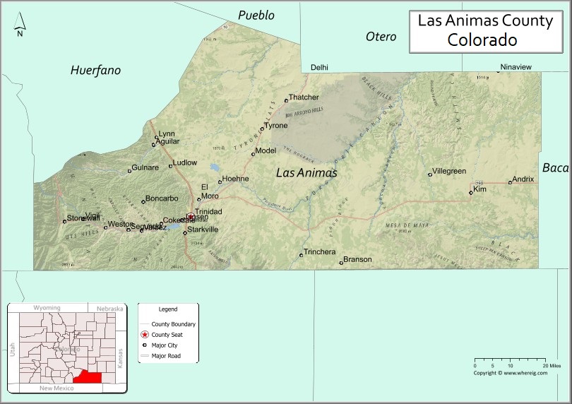
About Las Animas County Map, Colorado: The map showing the county boundary, county seat, major cities, highways, water bodies and neighbouring counties.
Most Viewed Links
Map of Las Animas County, Colorado
Las Animas County is a county located in the U.S. state of Colorado. It's county seat is Trinidad. As per 2020 census, the population of Las Animas County is 14633 people and population density is square miles. According to the United States Census Bureau, the county has a total area of 4,773.27 sq mi (12,363 km2). Las Animas County was established on -12377.
Las Animas County Facts
| Continent | North America |
| Country | United States |
| State | Colorado |
| County Seat | Trinidad |
| Largest City/Town | Trinidad |
| Established | 1866 |
| Total Area | 4,775 sq mi (12,367 sq km) |
| Land Area | 4,773 sq mi (12,362 sq km) |
| Water Area | 2 sq mi (5 sq km) |
| Population | 14,555 (Census 2020) |
| Population Density | 3.0 people per sq mi |
| Time Zone | Mountain Time Zone (MST/MDT) |
| Major Highways | Interstate 25, US Highway 160, State Highway 12 |
| Major Rivers | Purgatoire River, Canadian River watershed |
| Neighboring Counties | Huerfano County, Costilla County, Baca County, Otero County, Bent County, Colfax County (NM) |
| Famous For | Trinidad, Spanish Peaks, coal mining history, and scenic southern Colorado landscapes |
| Top Attractions | Trinidad Lake State Park, Fishers Peak, Highway of Legends, Ludlow Monument |
| Official Website | Official Website |
About Las Animas County, Colorado
Las Animas County is located in southern Colorado in the United States and was established in 1866. The county seat and largest city is Trinidad. The county is known for ranching, coal mining history, scenic mountain landscapes, outdoor recreation, and historic communities near the New Mexico border.
Cities and Towns in Las Animas County, Colorado
| City/Town | Population (Census 2020) | Latitude & Longitude |
|---|---|---|
| Trinidad (county seat) | 8,329 | 37.1695°N, 104.5005°W |
| Aguilar | 435 | 37.4028°N, 104.6542°W |
| Kim | 65 | 37.2486°N, 103.3578°W |
| Branson | 58 | 37.0003°N, 103.8908°W |
| Cokedale | 129 | 37.1358°N, 104.6197°W |
| Hoehne (CDP) | 123 | 37.2872°N, 104.3731°W |
| Stonewall (community) | Historic area | 37.1525°N, 105.0142°W |
| Weston (community) | Historic area | 37.1436°N, 104.8717°W |
Golf Courses in Las Animas County, Colorado
| Golf Course | Location | Latitude & Longitude |
|---|---|---|
| Trinidad Golf Course | Trinidad | 37.1775°N, 104.4958°W |
| Grandote Peaks Golf Club | La Veta nearby | 37.5058°N, 104.9989°W |
| Walsenburg Golf Area | Walsenburg nearby | 37.6453°N, 104.7797°W |
Roads and Highways in Las Animas County, Colorado
Major highways connect the county to New Mexico, southern Colorado cities, and scenic mountain regions.
- Interstate 25 - major north-south interstate connecting Trinidad with Pueblo and New Mexico
- US Highway 160 - east-west highway linking Trinidad with the San Luis Valley and Kansas
- Colorado State Highway 12 - scenic Highway of Legends route through mountain valleys and historic towns
Neighboring Counties of Las Animas County
- Huerfano County (northwest)
- Otero County (north)
- Bent County (northeast)
- Baca County (east)
- Costilla County (west)
- Colfax County, New Mexico (south)
Top Attractions in Las Animas County, Colorado
The county offers a mix of natural, historical, and recreational attractions.
- Trinidad Lake State Park - reservoir recreation area with boating, camping, and fishing
- Fishers Peak State Park - mountain park with hiking trails and panoramic views
- Highway of Legends Scenic Byway - scenic route through the Spanish Peaks region
- Ludlow Monument - historic labor history site commemorating the Ludlow Massacre
- Historic Downtown Trinidad - art galleries, restaurants, and preserved architecture
- Spanish Peaks region - scenic volcanic mountain peaks and hiking opportunities
- Cokedale Historic District - preserved coal mining community and museum area
- Comanche National Grassland nearby - prairie recreation and wildlife viewing destination
- Santa Fe Trail historic routes - remnants of important trade and migration trails
- Stonewall and Monument Lake areas - mountain recreation and fishing destinations
- Simpson's Rest overlook - scenic viewpoint above Trinidad
- Purgatoire River Valley - canyon scenery and outdoor recreation opportunities
Distance from Las Animas County to Nearby Cities
The following distances are measured by road (driving).
- Trinidad to Pueblo (Pueblo County), Colorado - 84 mi (135 km)
- Trinidad to Walsenburg (Huerfano County), Colorado - 49 mi (79 km)
- Trinidad to Colorado Springs (El Paso County), Colorado - 133 mi (214 km)
- Trinidad to Raton (Colfax County), New Mexico - 26 mi (42 km)
- Trinidad to Alamosa (Alamosa County), Colorado - 133 mi (214 km)
- Trinidad to Denver (Denver County), Colorado - 210 mi (338 km)
- Trinidad to Amarillo (Potter County), Texas - 272 mi (438 km)
- Trinidad to Santa Fe (Santa Fe County), New Mexico - 188 mi (303 km)
- Trinidad to La Junta (Otero County), Colorado - 82 mi (132 km)
- Trinidad to Durango (La Plata County), Colorado - 240 mi (386 km)
- Trinidad to Taos (Taos County), New Mexico - 131 mi (211 km)
- Trinidad to Wichita (Sedgwick County), Kansas - 382 mi (615 km)
FAQs about Las Animas County
Las Animas County is located in southern Colorado near the New Mexico border in the United States.
The population of Las Animas County was 14,555 according to the Census 2020.
Las Animas County is known for Trinidad, coal mining history, the Spanish Peaks region, and scenic mountain landscapes.
The county is served by Interstate 25, US Highway 160, and Colorado State Highway 12.
Popular attractions include Trinidad Lake State Park, Fishers Peak State Park, the Highway of Legends, and the Ludlow Monument.
References
- QuickFacts - U.S. Census Bureau
- United States Census Bureau
- United States Geological Survey (USGS)
- National Geodetic Survey
- Official Website
- Adams County Map
- Alamosa County Map
- Arapahoe County Map
- Archuleta County Map
- Baca County Map
- Bent County Map
- Boulder County Map
- Broomfield County Map
- Chaffee County Map
- Cheyenne County Map
- Clear Creek County Map
- Conejos County Map
- Costilla County Map
- Crowley County Map
- Custer County Map
- Delta County Map
- Denver County Map
- Dolores County Map
- Douglas County Map
- Eagle County Map
- Elbert County Map
- El Paso County Map
- Fremont County Map
- Garfield County Map
- Gilpin County Map
- Grand County Map
- Gunnison County Map
- Hinsdale County Map
- Huerfano County Map
- Jackson County Map
- Jefferson County Map
- Kiowa County Map
- Kit Carson County Map
- Lake County Map
- La Plata County Map
- Larimer County Map
- Las Animas County Map
- Lincoln County Map
- Logan County Map
- Mesa County Map
- Mineral County Map
- Moffat County Map
- Montezuma County Map
- Montrose County Map
- Morgan County Map
- Otero County Map
- Ouray County Map
- Park County Map
- Phillips County Map
- Pitkin County Map
- Prowers County Map
- Pueblo County Map
- Rio Blanco County Map
- Rio Grande County Map
- Routt County Map
- Saguache County Map
- San Juan County Map
- San Miguel County Map
- Sedgwick County Map
- Summit County Map
- Teller County Map
- Washington County Map
- Weld County Map
- Yuma County Map
- Alabama Counties
- Alaska boroughs
- Arizona Counties
- Arkansas Counties
- California County Map
- Colorado Counties
- Connecticut Counties
- Delaware Counties
- Florida County Map
- Georgia County Map
- Hawaii Counties
- Idaho Counties
- Illinois Counties
- Indiana Counties
- Iowa Counties
- Kansas Counties
- Kentucky Counties
- Louisiana Counties
- Maine Counties
- Maryland Counties
- Massachusetts Counties
- Michigan County Map
- Minnesota Counties
- Mississippi Counties
- Missouri Counties
- Montana Counties
- Nebraska Counties
- Nevada Counties
- New York Counties
- New Hampshire Counties
- New Jersey Counties
- New Mexico Counties
- North Carolina Counties
- North Dakota Counties
- Ohio County Map
- Oklahoma Counties
- Oregon Counties
- Pennsylvania Counties
- Rhode Island Counties
- South Carolina Counties
- South Dakota Counties
- Map of Tennessee
- Texas County Map
- Utah Counties
- Vermont Counties
- Virginia Counties
- Washington Counties
- West Virginia Counties
- Wisconsin Counties
- Wyoming Counties