Map of Jackson County - Jackson County is a county located in the U.S. state of Colorado. Jackson County Map showing cities, highways, important places and water bodies. Get Where is Jackson County located in the map, major cities in Jackson county, population, areas, and places of interest.
Map of Jackson County, Colorado
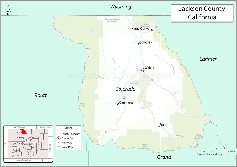
About Jackson County Map, Colorado: The map showing the county boundary, county seat, major cities, highways, water bodies and neighbouring counties.
Most Viewed Links
Map of Jackson County, Colorado
Jackson County is a county located in the U.S. state of Colorado. It's county seat is Walden. As per 2020 census, the population of Jackson County is 1363 people and population density is square miles. According to the United States Census Bureau, the county has a total area of 1,619.75 sq mi (4,195 km2). Jackson County was established on 3413.
Jackson County Facts
| Continent | North America |
| Country | United States |
| State | Colorado |
| County Seat | Walden |
| Largest City/Town | Walden |
| Established | 1909 |
| Total Area | 1,628 sq mi (4,217 sq km) |
| Land Area | 1,614 sq mi (4,180 sq km) |
| Water Area | 14 sq mi (36 sq km) |
| Population | 1,363 (Census 2020) |
| Population Density | 0.8 people per sq mi |
| Time Zone | Mountain Time Zone (MST/MDT) |
| Major Highways | State Highway 14, State Highway 125 |
| Major Rivers | North Platte River, Michigan River |
| Neighboring Counties | Larimer County, Grand County, Routt County |
| Famous For | North Park basin, ranching, fishing, wildlife, and scenic mountain landscapes |
| Top Attractions | State Forest State Park, North Platte River, Arapaho National Wildlife Refuge, Gould |
| Official Website | Official Website |
About Jackson County, Colorado
Jackson County is located in north-central Colorado in the United States and was established in 1909. The county seat and largest town is Walden. The county is known for ranching, wide-open valleys, fishing streams, wildlife habitats, and outdoor recreation in the scenic North Park region.
Cities and Communities in Jackson County, Colorado
| City/Town | Population (Census 2020) | Latitude & Longitude |
|---|---|---|
| Walden (county seat) | 606 | 40.7314°N, 106.2831°W |
| Gould (CDP) | 118 | 40.5136°N, 106.0261°W |
| Coalmont (CDP) | 74 | 40.5547°N, 106.4450°W |
| Rand (CDP) | 15 | 40.4744°N, 106.1833°W |
| North Park communities | Regional area | 40.7000°N, 106.3000°W |
Golf Courses in Jackson County, Colorado
| Golf Course | Location | Latitude & Longitude |
|---|---|---|
| Walden Golf Course | Walden | 40.7319°N, 106.2828°W |
| Haymaker Golf Course | Steamboat Springs nearby | 40.5069°N, 106.8456°W |
| Grand Elk Golf Club | Granby nearby | 40.0867°N, 105.9333°W |
Roads and Highways in Jackson County, Colorado
Major highways connect the county to mountain recreation areas and neighboring northern Colorado regions.
- Colorado State Highway 14 - scenic route connecting Walden with Fort Collins and Routt County
- Colorado State Highway 125 - north-south highway linking Jackson County with Grand County and Wyoming
Neighboring Counties of Jackson County
- Larimer County (east)
- Grand County (south)
- Routt County (west)
Top Attractions in Jackson County, Colorado
The county offers a mix of natural and recreational attractions.
- State Forest State Park - mountain recreation area known for moose viewing, hiking, and camping
- Arapaho National Wildlife Refuge - wildlife habitat featuring migratory birds and scenic wetlands
- North Platte River - fishing, rafting, and wildlife viewing destination
- Never Summer Mountains nearby - rugged mountain range with hiking and alpine scenery
- Gould and North Park Valley - scenic ranching landscapes and outdoor recreation
- Lake John State Wildlife Area - popular fishing and camping area
- Michigan River recreation areas - fishing streams and mountain scenery
- Buffalo Pass nearby - scenic mountain route connecting to Steamboat Springs
- Walden Historic Downtown - small-town district with museums and local history attractions
- Mount Zirkel Wilderness access areas - wilderness hiking and backpacking destinations
- Delaney Buttes fishing lakes - well-known trout fishing area
- Moose Visitor Center - educational center focusing on local wildlife and ecosystems
Distance from Jackson County to Nearby Cities
The following distances are measured by road (driving).
- Walden to Fort Collins (Larimer County), Colorado - 96 mi (154 km)
- Walden to Steamboat Springs (Routt County), Colorado - 66 mi (106 km)
- Walden to Granby (Grand County), Colorado - 58 mi (93 km)
- Walden to Denver (Denver County), Colorado - 144 mi (232 km)
- Walden to Boulder (Boulder County), Colorado - 123 mi (198 km)
- Walden to Laramie (Albany County), Wyoming - 70 mi (113 km)
- Walden to Cheyenne (Laramie County), Wyoming - 109 mi (175 km)
- Walden to Estes Park (Larimer County), Colorado - 78 mi (126 km)
- Walden to Winter Park (Grand County), Colorado - 77 mi (124 km)
- Walden to Vail (Eagle County), Colorado - 138 mi (222 km)
- Walden to Colorado Springs (El Paso County), Colorado - 214 mi (344 km)
- Walden to Grand Junction (Mesa County), Colorado - 266 mi (428 km)
FAQs about Jackson County
Jackson County is located in north-central Colorado within the North Park region near the Wyoming border in the United States.
The population of Jackson County was 1,363 according to the Census 2020.
Jackson County is known for ranching, fishing, wildlife habitats, scenic valleys, and outdoor recreation.
The county is served by Colorado State Highway 14 and Colorado State Highway 125.
Popular attractions include State Forest State Park, Arapaho National Wildlife Refuge, North Platte River, and the North Park region.
References
- QuickFacts - U.S. Census Bureau
- United States Census Bureau
- United States Geological Survey (USGS)
- National Geodetic Survey
- Official Website
- Adams County Map
- Alamosa County Map
- Arapahoe County Map
- Archuleta County Map
- Baca County Map
- Bent County Map
- Boulder County Map
- Broomfield County Map
- Chaffee County Map
- Cheyenne County Map
- Clear Creek County Map
- Conejos County Map
- Costilla County Map
- Crowley County Map
- Custer County Map
- Delta County Map
- Denver County Map
- Dolores County Map
- Douglas County Map
- Eagle County Map
- Elbert County Map
- El Paso County Map
- Fremont County Map
- Garfield County Map
- Gilpin County Map
- Grand County Map
- Gunnison County Map
- Hinsdale County Map
- Huerfano County Map
- Jackson County Map
- Jefferson County Map
- Kiowa County Map
- Kit Carson County Map
- Lake County Map
- La Plata County Map
- Larimer County Map
- Las Animas County Map
- Lincoln County Map
- Logan County Map
- Mesa County Map
- Mineral County Map
- Moffat County Map
- Montezuma County Map
- Montrose County Map
- Morgan County Map
- Otero County Map
- Ouray County Map
- Park County Map
- Phillips County Map
- Pitkin County Map
- Prowers County Map
- Pueblo County Map
- Rio Blanco County Map
- Rio Grande County Map
- Routt County Map
- Saguache County Map
- San Juan County Map
- San Miguel County Map
- Sedgwick County Map
- Summit County Map
- Teller County Map
- Washington County Map
- Weld County Map
- Yuma County Map
- Alabama Counties
- Alaska boroughs
- Arizona Counties
- Arkansas Counties
- California County Map
- Colorado Counties
- Connecticut Counties
- Delaware Counties
- Florida County Map
- Georgia County Map
- Hawaii Counties
- Idaho Counties
- Illinois Counties
- Indiana Counties
- Iowa Counties
- Kansas Counties
- Kentucky Counties
- Louisiana Counties
- Maine Counties
- Maryland Counties
- Massachusetts Counties
- Michigan County Map
- Minnesota Counties
- Mississippi Counties
- Missouri Counties
- Montana Counties
- Nebraska Counties
- Nevada Counties
- New York Counties
- New Hampshire Counties
- New Jersey Counties
- New Mexico Counties
- North Carolina Counties
- North Dakota Counties
- Ohio County Map
- Oklahoma Counties
- Oregon Counties
- Pennsylvania Counties
- Rhode Island Counties
- South Carolina Counties
- South Dakota Counties
- Map of Tennessee
- Texas County Map
- Utah Counties
- Vermont Counties
- Virginia Counties
- Washington Counties
- West Virginia Counties
- Wisconsin Counties
- Wyoming Counties