Map of Eagle County - Eagle County is a county located in the U.S. state of Colorado. Eagle County Map showing cities, highways, important places and water bodies. Get Where is Eagle County located in the map, major cities in Eagle county, population, areas, and places of interest.
Map of Eagle County, Colorado
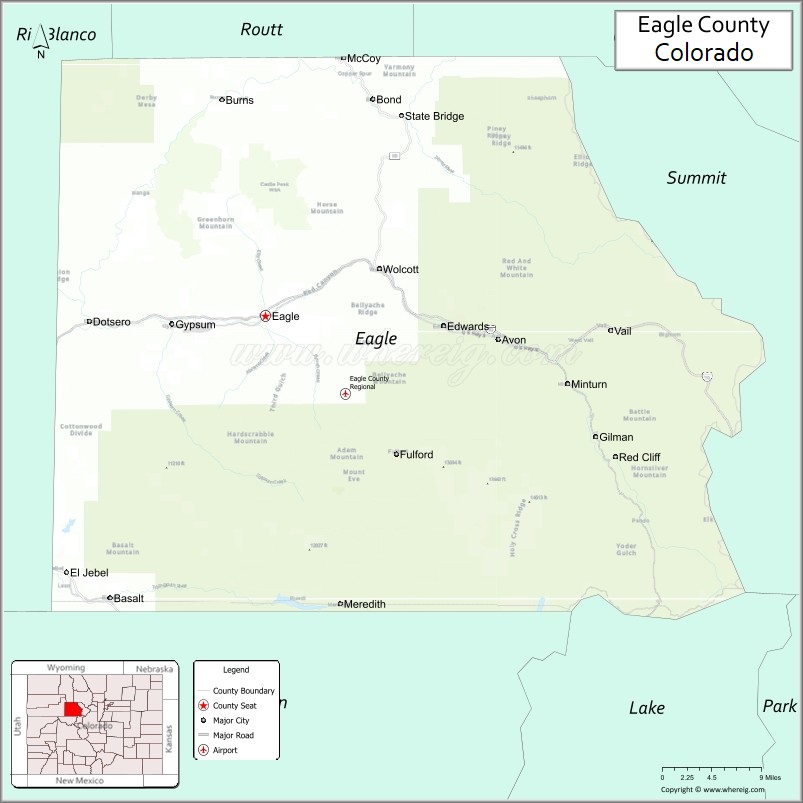
About Eagle County Map, Colorado: The map showing the county boundary, county seat, major cities, highways, water bodies and neighbouring counties.
Most Viewed Links
Map of Eagle County, Colorado
Eagle County is a county located in the U.S. state of Colorado. It's county seat is Eagle. As per 2020 census, the population of Eagle County is 55727 people and population density is square miles. According to the United States Census Bureau, the county has a total area of 1,700.76 sq mi (4,405 km2). Eagle County was established on -6166.
Eagle County Facts
| County Info | Facts |
|---|---|
| County | Eagle County |
| County Seat | Eagle |
| State | Colorado |
| Country | United States |
| FIPS code | 37 |
| Established | -6166 |
| Area | 1,700.76 sq mi (4,405 km2) |
| Population | 55727 |
| Density | |
| Formed / Origin | Split from Summit County. |
Ctities in Eagle county
| City Name | Type | Population (2020) |
|---|---|---|
| Avon | home rule town | 6,072 |
| Basalt | home rule town | 2,917 |
| Gypsum | home rule town | 8,040 |
| Minturn | home rule town | 1,033 |
| Red Cliff | statutory town | 257 |
| Vail | home rule town | 4,835 |
| Eagle | statutory town | 7,511 |
Places to Visit in Eagle
Top places to visit in Eagle includes Eagle Climbing + Fitness, Sylvan Lake State Park, Glenwood Caverns, Eagle Town Park, Eagle Ranch Golf Course, Mountain Recreation Eagle, Brush Creek Park and Pavilion, Beaver Creek Resort, The Ritz-Carlton, Bachelor Gulch.
Highways in Eagle
Interstate 70, I-70 BL, I-70 BL, I-70 BL, U.S. Highway 6, U.S. Highway 24, State Highway 82, State Highway 131.
Nearest Airports
Nearest airport of Eagle is Eagle (EGE) Airport.
- Adams County Map
- Alamosa County Map
- Arapahoe County Map
- Archuleta County Map
- Baca County Map
- Bent County Map
- Boulder County Map
- Broomfield County Map
- Chaffee County Map
- Cheyenne County Map
- Clear Creek County Map
- Conejos County Map
- Costilla County Map
- Crowley County Map
- Custer County Map
- Delta County Map
- Denver County Map
- Dolores County Map
- Douglas County Map
- Eagle County Map
- Elbert County Map
- El Paso County Map
- Fremont County Map
- Garfield County Map
- Gilpin County Map
- Grand County Map
- Gunnison County Map
- Hinsdale County Map
- Huerfano County Map
- Jackson County Map
- Jefferson County Map
- Kiowa County Map
- Kit Carson County Map
- Lake County Map
- La Plata County Map
- Larimer County Map
- Las Animas County Map
- Lincoln County Map
- Logan County Map
- Mesa County Map
- Mineral County Map
- Moffat County Map
- Montezuma County Map
- Montrose County Map
- Morgan County Map
- Otero County Map
- Ouray County Map
- Park County Map
- Phillips County Map
- Pitkin County Map
- Prowers County Map
- Pueblo County Map
- Rio Blanco County Map
- Rio Grande County Map
- Routt County Map
- Saguache County Map
- San Juan County Map
- San Miguel County Map
- Sedgwick County Map
- Summit County Map
- Teller County Map
- Washington County Map
- Weld County Map
- Yuma County Map
- Alabama Counties
- Alaska boroughs
- Arizona Counties
- Arkansas Counties
- California County Map
- Colorado Counties
- Connecticut Counties
- Delaware Counties
- Florida County Map
- Georgia County Map
- Hawaii Counties
- Idaho Counties
- Illinois Counties
- Indiana Counties
- Iowa Counties
- Kansas Counties
- Kentucky Counties
- Louisiana Counties
- Maine Counties
- Maryland Counties
- Massachusetts Counties
- Michigan County Map
- Minnesota Counties
- Mississippi Counties
- Missouri Counties
- Montana Counties
- Nebraska Counties
- New Hampshire Counties
- New Jersey Counties
- New Mexico Counties
- North Carolina Counties
- North Dakota Counties
- Oklahoma Counties
- Oregon Counties
- Pennsylvania Counties
- Rhode Island Counties
- South Carolina Counties
- South Dakota Counties
- Map of Tennessee
- Texas County Map
- Utah Counties
- Vermont Counties
- Virginia Counties
- Washington Counties
- West Virginia Counties
- Wisconsin Counties
- Wyoming Counties
- Nevada Counties
- New York Counties
- Ohio County Map