Map of San Juan County - San Juan County is a county located in the U.S. state of Colorado. San Juan County Map showing cities, highways, important places and water bodies. Get Where is San Juan County located in the map, major cities in San Juan county, population, areas, and places of interest.
Map of San Juan County, Colorado
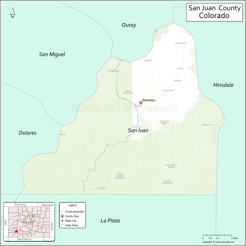
About San Juan County Map, Colorado: The map showing the county boundary, county seat, major cities, highways, water bodies and neighbouring counties.
Most Viewed Links
Map of San Juan County, Colorado
San Juan County is a county located in the U.S. state of Colorado. It's county seat is Silverton. As per 2020 census, the population of San Juan County is 733 people and population density is square miles. According to the United States Census Bureau, the county has a total area of 388.99 sq mi (1,007 km2). San Juan County was established on -8734.
San Juan County Facts
| Continent | North America |
| Country | United States |
| State | Colorado |
| County Seat | Silverton |
| Largest City/Town | Silverton |
| Established | 1876 |
| Total Area | 388 sq mi (1,005 sq km) |
| Land Area | 388 sq mi (1,005 sq km) |
| Water Area | 0.1 sq mi (0.3 sq km) |
| Population | 705 (Census 2020) |
| Population Density | 1.8 people per sq mi |
| Time Zone | Mountain Time Zone (MST/MDT) |
| Major Highways | US Highway 550 |
| Major Rivers | Animas River |
| Neighboring Counties | Ouray County, Hinsdale County, Mineral County, La Plata County, San Miguel County |
| Famous For | Silverton mining history, alpine scenery, Million Dollar Highway, and mountain recreation |
| Top Attractions | Durango & Silverton Narrow Gauge Railroad, Ice Lakes Trail, Molas Pass, Alpine Loop Scenic Byway |
| Official Website | Official Website |
About San Juan County, Colorado
San Juan County is located in southwestern Colorado in the United States and was established in 1876. The county seat and only incorporated town is Silverton. The county is known for dramatic mountain scenery, historic mining towns, alpine recreation, and scenic routes through the San Juan Mountains.
Cities and Communities in San Juan County, Colorado
| City/Town | Population (Census 2020) | Latitude & Longitude |
|---|---|---|
| Silverton (county seat) | 622 | 37.8119°N, 107.6645°W |
| Animas Forks | Historic ghost town | 37.9311°N, 107.5956°W |
| Eureka | Historic mining site | 37.8850°N, 107.6614°W |
| Howardsville | Historic mining community | 37.8397°N, 107.6014°W |
| Molas Pass area | Mountain recreation region | 37.7475°N, 107.6925°W |
| Red Mountain Pass area | Scenic mountain region | 37.8994°N, 107.7150°W |
| Cunningham Gulch | Alpine recreation area | 37.8325°N, 107.6669°W |
| Alpine Loop region | Historic jeep trail area | 37.9500°N, 107.6500°W |
Golf Courses in San Juan County, Colorado
| Golf Course | Location | Latitude & Longitude |
|---|---|---|
| Hillcrest Golf Club | Durango nearby | 37.2750°N, 107.8808°W |
| Dalton Ranch Golf Club | Durango nearby | 37.3847°N, 107.8686°W |
| Divide Ranch & Club | Ridgway nearby | 38.1517°N, 107.7581°W |
Roads and Highways in San Juan County, Colorado
Major highways connect the county to mountain passes, historic mining regions, and southwestern Colorado communities.
- US Highway 550 - scenic Million Dollar Highway route connecting Silverton with Durango and Ouray
Neighboring Counties of San Juan County
- Ouray County (north)
- San Miguel County (northwest)
- Hinsdale County (east)
- Mineral County (southeast)
- La Plata County (south)
Top Attractions in San Juan County, Colorado
The county offers a mix of alpine scenery, historic mining attractions, and outdoor recreation destinations.
- Durango & Silverton Narrow Gauge Railroad - historic scenic train route through mountain canyons
- Million Dollar Highway - famous scenic mountain highway with dramatic cliffside views
- Ice Lakes Trail - popular alpine hiking route featuring turquoise lakes and mountain scenery
- Alpine Loop Scenic Byway - historic jeep trail connecting old mining towns and mountain passes
- Molas Pass - scenic overlook and hiking destination in the San Juan Mountains
- Animas Forks Ghost Town - preserved mining-era ghost town in the high mountains
- Red Mountain Pass - alpine scenic route with colorful mountain landscapes
- Silverton Historic District - preserved Victorian mining town with museums and shops
- Kendall Mountain Recreation Area - skiing, hiking, and year-round outdoor recreation
- San Juan National Forest recreation areas - camping, fishing, and wilderness exploration
- Mining heritage museums and tours - exhibits on Colorado silver mining history
- Off-road jeep trails and mountain passes - adventure tourism and alpine exploration opportunities
Distance from San Juan County to Nearby Cities
The following distances are measured by road (driving).
- Silverton to Durango (La Plata County), Colorado - 48 mi (77 km)
- Silverton to Ouray (Ouray County), Colorado - 24 mi (39 km)
- Silverton to Telluride (San Miguel County), Colorado - 73 mi (117 km)
- Silverton to Montrose (Montrose County), Colorado - 60 mi (97 km)
- Silverton to Pagosa Springs (Archuleta County), Colorado - 91 mi (146 km)
- Silverton to Grand Junction (Mesa County), Colorado - 148 mi (238 km)
- Silverton to Gunnison (Gunnison County), Colorado - 132 mi (212 km)
- Silverton to Aspen (Pitkin County), Colorado - 175 mi (282 km)
- Silverton to Santa Fe (Santa Fe County), New Mexico - 244 mi (393 km)
- Silverton to Albuquerque (Bernalillo County), New Mexico - 290 mi (467 km)
- Silverton to Denver (Denver County), Colorado - 364 mi (586 km)
- Silverton to Moab (Grand County), Utah - 187 mi (301 km)
FAQs about San Juan County
San Juan County is located in southwestern Colorado within the San Juan Mountains region of the United States.
The population of San Juan County was 705 according to the Census 2020.
San Juan County is known for Silverton, alpine scenery, historic mining towns, and the Million Dollar Highway.
The county is primarily served by US Highway 550, also known as the Million Dollar Highway.
Popular attractions include the Durango & Silverton Narrow Gauge Railroad, Ice Lakes Trail, Molas Pass, and the Alpine Loop Scenic Byway.
References
- QuickFacts - U.S. Census Bureau
- United States Census Bureau
- United States Geological Survey (USGS)
- National Geodetic Survey
- Official Website
- Adams County Map
- Alamosa County Map
- Arapahoe County Map
- Archuleta County Map
- Baca County Map
- Bent County Map
- Boulder County Map
- Broomfield County Map
- Chaffee County Map
- Cheyenne County Map
- Clear Creek County Map
- Conejos County Map
- Costilla County Map
- Crowley County Map
- Custer County Map
- Delta County Map
- Denver County Map
- Dolores County Map
- Douglas County Map
- Eagle County Map
- Elbert County Map
- El Paso County Map
- Fremont County Map
- Garfield County Map
- Gilpin County Map
- Grand County Map
- Gunnison County Map
- Hinsdale County Map
- Huerfano County Map
- Jackson County Map
- Jefferson County Map
- Kiowa County Map
- Kit Carson County Map
- Lake County Map
- La Plata County Map
- Larimer County Map
- Las Animas County Map
- Lincoln County Map
- Logan County Map
- Mesa County Map
- Mineral County Map
- Moffat County Map
- Montezuma County Map
- Montrose County Map
- Morgan County Map
- Otero County Map
- Ouray County Map
- Park County Map
- Phillips County Map
- Pitkin County Map
- Prowers County Map
- Pueblo County Map
- Rio Blanco County Map
- Rio Grande County Map
- Routt County Map
- Saguache County Map
- San Juan County Map
- San Miguel County Map
- Sedgwick County Map
- Summit County Map
- Teller County Map
- Washington County Map
- Weld County Map
- Yuma County Map
- Alabama Counties
- Alaska boroughs
- Arizona Counties
- Arkansas Counties
- California County Map
- Colorado Counties
- Connecticut Counties
- Delaware Counties
- Florida County Map
- Georgia County Map
- Hawaii Counties
- Idaho Counties
- Illinois Counties
- Indiana Counties
- Iowa Counties
- Kansas Counties
- Kentucky Counties
- Louisiana Counties
- Maine Counties
- Maryland Counties
- Massachusetts Counties
- Michigan County Map
- Minnesota Counties
- Mississippi Counties
- Missouri Counties
- Montana Counties
- Nebraska Counties
- Nevada Counties
- New York Counties
- New Hampshire Counties
- New Jersey Counties
- New Mexico Counties
- North Carolina Counties
- North Dakota Counties
- Ohio County Map
- Oklahoma Counties
- Oregon Counties
- Pennsylvania Counties
- Rhode Island Counties
- South Carolina Counties
- South Dakota Counties
- Map of Tennessee
- Texas County Map
- Utah Counties
- Vermont Counties
- Virginia Counties
- Washington Counties
- West Virginia Counties
- Wisconsin Counties
- Wyoming Counties