Map of Elbert County - Elbert County is a county located in the U.S. state of Colorado. Elbert County Map showing cities, highways, important places and water bodies. Get Where is Elbert County located in the map, major cities in Elbert county, population, areas, and places of interest.
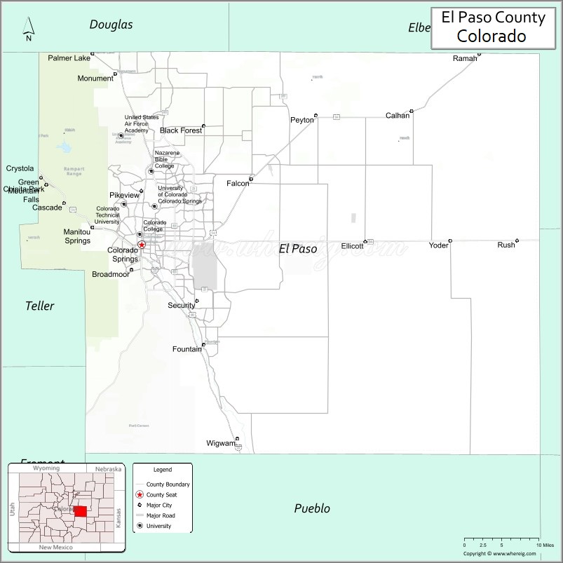
Map of El Paso County, Colorado
About Elbert County Map, Colorado: The map showing the county boundary, county seat, major cities, highways, water bodies and neighbouring counties.
Most Viewed Links
Map of El Paso County, Colorado
El Paso County is a county located in the U.S. state of Colorado. It's county seat is Colorado Springs. As per 2020 census, the population of El Paso County is 737867 people and population density is square miles. According to the United States Census Bureau, the county has a total area of 2,128.60 sq mi (5,513 km2). El Paso County was established on -13938.
El Paso County Facts
| Continent | North America |
| Country | United States |
| State | Colorado |
| County Seat | Colorado Springs |
| Largest City/Town | Colorado Springs |
| Established | 1861 |
| Total Area | 2,130 sq mi (5,517 sq km) |
| Land Area | 2,126 sq mi (5,507 sq km) |
| Water Area | 4 sq mi (10 sq km) |
| Population | 730,395 (Census 2020) |
| Population Density | 343.5 people per sq mi |
| Time Zone | Mountain Time Zone (MST/MDT) |
| Major Highways | Interstate 25, US Highway 24, State Highway 21, State Highway 83, State Highway 94 |
| Major Rivers | Fountain Creek, Arkansas River watershed |
| Neighboring Counties | Douglas County, Elbert County, Lincoln County, Pueblo County, Teller County, Fremont County |
| Famous For | Colorado Springs, Pikes Peak, military bases, Garden of the Gods, and outdoor recreation |
| Top Attractions | Pikes Peak, Garden of the Gods, United States Air Force Academy, Cheyenne Mountain Zoo |
| Official Website | Official Website |
About El Paso County, Colorado
El Paso County is located in central Colorado in the United States and was established in 1861 as one of the original counties of the Colorado Territory. The county seat and largest city is Colorado Springs. The county is known for mountain scenery, military installations, tourism attractions, outdoor recreation, and rapid population growth along the Front Range.
Cities and Towns in El Paso County, Colorado
| City/Town | Population (Census 2020) | Latitude & Longitude |
|---|---|---|
| Colorado Springs (county seat) | 478,961 | 38.8339°N, 104.8214°W |
| Fountain | 29,802 | 38.6822°N, 104.7008°W |
| Manitou Springs | 5,078 | 38.8597°N, 104.9172°W |
| Monument | 9,306 | 39.0911°N, 104.8728°W |
| Calhan | 762 | 39.0358°N, 104.2972°W |
| Green Mountain Falls | 640 | 38.9342°N, 105.0172°W |
| Palmer Lake | 2,636 | 39.1197°N, 104.9175°W |
| Ramah | 111 | 39.1228°N, 104.1658°W |
| Security-Widefield (CDP) | 38,188 | 38.7475°N, 104.7411°W |
| Cimarron Hills (CDP) | 19,816 | 38.8589°N, 104.6986°W |
Golf Courses in El Paso County, Colorado
| Golf Course | Location | Latitude & Longitude |
|---|---|---|
| Broadmoor Golf Club | Colorado Springs | 38.7914°N, 104.8456°W |
| Pine Creek Golf Club | Colorado Springs | 38.9700°N, 104.7817°W |
| Patty Jewett Golf Course | Colorado Springs | 38.8511°N, 104.7989°W |
| Kissing Camels Golf Club | Colorado Springs | 38.8897°N, 104.8731°W |
| Kings Deer Golf Club | Monument | 39.0992°N, 104.8497°W |
| Shining Mountain Golf Club | Woodland Park nearby | 38.9928°N, 105.0506°W |
Roads and Highways in El Paso County, Colorado
Major highways connect the county to Denver, southern Colorado, and mountain recreation areas.
- Interstate 25 - major north-south interstate connecting Colorado Springs with Denver and Pueblo
- US Highway 24 - route linking Colorado Springs with the mountains and eastern plains
- Colorado State Highway 21 - Powers Boulevard serving eastern Colorado Springs
- Colorado State Highway 83 - scenic highway connecting Colorado Springs with Parker and Denver suburbs
- Colorado State Highway 94 - eastern route connecting Colorado Springs with Lincoln County
Neighboring Counties of El Paso County
- Douglas County (north)
- Elbert County (northeast)
- Lincoln County (east)
- Pueblo County (south)
- Fremont County (west)
- Teller County (west)
Top Attractions in El Paso County, Colorado
The county offers a mix of natural, historical, and recreational attractions.
- Pikes Peak - famous mountain summit accessible by scenic highway and cog railway
- Garden of the Gods - iconic red rock park with hiking, climbing, and scenic drives
- United States Air Force Academy - military academy with visitor center and chapel
- Cheyenne Mountain Zoo - mountain zoo featuring wildlife exhibits and scenic views
- The Broadmoor - historic luxury resort with golf courses and recreation facilities
- Seven Falls - scenic waterfall attraction in South Cheyenne Canyon
- Manitou Cliff Dwellings - reconstructed ancient cliff dwelling attraction
- Red Rock Canyon Open Space - hiking and biking area with sandstone formations
- Cheyenne Mountain State Park - state park with trails, camping, and wildlife viewing
- Old Colorado City - historic district with shops, restaurants, and galleries
- Paint Mines Interpretive Park - colorful geological formations and hiking trails
- Palmer Park - urban park known for scenic overlooks and recreation trails
Distance from El Paso County to Nearby Cities
The following distances are measured by road (driving).
- Colorado Springs to Denver (Denver County), Colorado - 70 mi (113 km)
- Colorado Springs to Pueblo (Pueblo County), Colorado - 45 mi (72 km)
- Colorado Springs to Castle Rock (Douglas County), Colorado - 41 mi (66 km)
- Colorado Springs to Canon City (Fremont County), Colorado - 45 mi (72 km)
- Colorado Springs to Woodland Park (Teller County), Colorado - 19 mi (31 km)
- Colorado Springs to Limon (Lincoln County), Colorado - 86 mi (138 km)
- Colorado Springs to Boulder (Boulder County), Colorado - 100 mi (161 km)
- Colorado Springs to Trinidad (Las Animas County), Colorado - 132 mi (212 km)
- Colorado Springs to Breckenridge (Summit County), Colorado - 111 mi (179 km)
- Colorado Springs to Salida (Chaffee County), Colorado - 105 mi (169 km)
- Colorado Springs to Grand Junction (Mesa County), Colorado - 243 mi (391 km)
- Colorado Springs to Estes Park (Larimer County), Colorado - 125 mi (201 km)
FAQs about El Paso County
El Paso County is located in central Colorado along the Front Range region of the Rocky Mountains in the United States.
The population of El Paso County was 730,395 according to the Census 2020.
El Paso County is known for Colorado Springs, Pikes Peak, military installations, and outdoor recreation attractions.
The county is served by Interstate 25, US Highway 24, Colorado State Highway 21, Colorado State Highway 83, and Colorado State Highway 94.
Yes, El Paso County has several golf courses including Broadmoor Golf Club, Pine Creek Golf Club, and Patty Jewett Golf Course.
References
- QuickFacts - U.S. Census Bureau
- United States Census Bureau
- United States Geological Survey (USGS)
- National Geodetic Survey
- Official Website
- Adams County Map
- Alamosa County Map
- Arapahoe County Map
- Archuleta County Map
- Baca County Map
- Bent County Map
- Boulder County Map
- Broomfield County Map
- Chaffee County Map
- Cheyenne County Map
- Clear Creek County Map
- Conejos County Map
- Costilla County Map
- Crowley County Map
- Custer County Map
- Delta County Map
- Denver County Map
- Dolores County Map
- Douglas County Map
- Eagle County Map
- Elbert County Map
- El Paso County Map
- Fremont County Map
- Garfield County Map
- Gilpin County Map
- Grand County Map
- Gunnison County Map
- Hinsdale County Map
- Huerfano County Map
- Jackson County Map
- Jefferson County Map
- Kiowa County Map
- Kit Carson County Map
- Lake County Map
- La Plata County Map
- Larimer County Map
- Las Animas County Map
- Lincoln County Map
- Logan County Map
- Mesa County Map
- Mineral County Map
- Moffat County Map
- Montezuma County Map
- Montrose County Map
- Morgan County Map
- Otero County Map
- Ouray County Map
- Park County Map
- Phillips County Map
- Pitkin County Map
- Prowers County Map
- Pueblo County Map
- Rio Blanco County Map
- Rio Grande County Map
- Routt County Map
- Saguache County Map
- San Juan County Map
- San Miguel County Map
- Sedgwick County Map
- Summit County Map
- Teller County Map
- Washington County Map
- Weld County Map
- Yuma County Map
- Alabama Counties
- Alaska boroughs
- Arizona Counties
- Arkansas Counties
- California County Map
- Colorado Counties
- Connecticut Counties
- Delaware Counties
- Florida County Map
- Georgia County Map
- Hawaii Counties
- Idaho Counties
- Illinois Counties
- Indiana Counties
- Iowa Counties
- Kansas Counties
- Kentucky Counties
- Louisiana Counties
- Maine Counties
- Maryland Counties
- Massachusetts Counties
- Michigan County Map
- Minnesota Counties
- Mississippi Counties
- Missouri Counties
- Montana Counties
- Nebraska Counties
- Nevada Counties
- New York Counties
- New Hampshire Counties
- New Jersey Counties
- New Mexico Counties
- North Carolina Counties
- North Dakota Counties
- Ohio County Map
- Oklahoma Counties
- Oregon Counties
- Pennsylvania Counties
- Rhode Island Counties
- South Carolina Counties
- South Dakota Counties
- Map of Tennessee
- Texas County Map
- Utah Counties
- Vermont Counties
- Virginia Counties
- Washington Counties
- West Virginia Counties
- Wisconsin Counties
- Wyoming Counties