Map of Morgan County - Morgan County is a county located in the U.S. state of Colorado. Morgan County Map showing cities, highways, important places and water bodies. Get Where is Morgan County located in the map, major cities in Morgan county, population, areas, and places of interest.
Map of Morgan County, Colorado
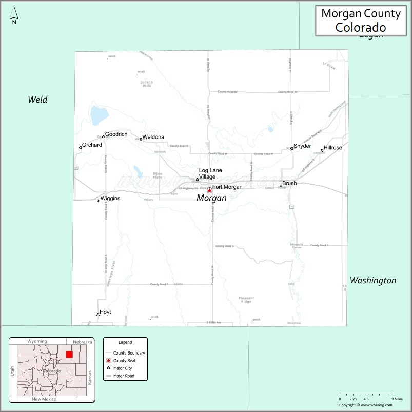
About Morgan County Map, Colorado: The map showing the county boundary, county seat, major cities, highways, water bodies and neighbouring counties.
Most Viewed Links
Map of Morgan County, Colorado
Morgan County is a county located in the U.S. state of Colorado. It's county seat is Fort Morgan. As per 2020 census, the population of Morgan County is 29008 people and population density is square miles. According to the United States Census Bureau, the county has a total area of 1,293.83 sq mi (3,351 km2). Morgan County was established on -3966.
Morgan County Facts
| Continent | North America |
| Country | United States |
| State | Colorado |
| County Seat | Fort Morgan |
| Largest City/Town | Fort Morgan |
| Established | 1889 |
| Total Area | 1,299 sq mi (3,364 sq km) |
| Land Area | 1,285 sq mi (3,328 sq km) |
| Water Area | 14 sq mi (36 sq km) |
| Population | 29,111 (Census 2020) |
| Population Density | 22.7 people per sq mi |
| Time Zone | Mountain Time Zone (MST/MDT) |
| Major Highways | Interstate 76, US Highway 34, State Highway 52, State Highway 71 |
| Major Rivers | South Platte River |
| Neighboring Counties | Weld County, Logan County, Washington County, Adams County |
| Famous For | Agriculture, Fort Morgan, South Platte River valley, and northeastern Colorado farming communities |
| Top Attractions | Jackson Lake State Park nearby, Fort Morgan Museum, Riverside Park, South Platte River recreation |
| Official Website | Official Website |
About Morgan County, Colorado
Morgan County is located in northeastern Colorado in the United States and was established in 1889. The county seat and largest city is Fort Morgan. The county is known for agriculture, irrigation farming, cattle production, prairie landscapes, and transportation routes across the South Platte River valley.
Cities and Towns in Morgan County, Colorado
| City/Town | Population (Census 2020) | Latitude & Longitude |
|---|---|---|
| Fort Morgan (county seat) | 11,597 | 40.2503°N, 103.8019°W |
| Brush | 5,339 | 40.2583°N, 103.6233°W |
| Wiggins | 1,364 | 40.2314°N, 104.0731°W |
| Hillrose | 264 | 40.3297°N, 103.5281°W |
| Log Lane Village | 873 | 40.2722°N, 103.8053°W |
| Orchard | 64 | 40.3339°N, 103.1339°W |
| Snyder | 226 | 40.3331°N, 103.5794°W |
| Weldona | 113 | 40.3272°N, 103.9678°W |
Golf Courses in Morgan County, Colorado
| Golf Course | Location | Latitude & Longitude |
|---|---|---|
| Quail Dunes Golf Course | Fort Morgan | 40.2453°N, 103.7928°W |
| Bunker Hill Country Club | Brush | 40.2572°N, 103.6239°W |
| Riverview Golf Club | Sterling nearby | 40.6297°N, 103.2153°W |
Roads and Highways in Morgan County, Colorado
Major highways connect the county to Denver, northeastern Colorado communities, and regional agricultural areas.
- Interstate 76 - major interstate connecting Fort Morgan with Denver and Nebraska
- US Highway 34 - east-west route linking Fort Morgan with Greeley and Nebraska
- Colorado State Highway 52 - highway connecting Fort Morgan with northeastern plains communities
- Colorado State Highway 71 - north-south highway serving eastern Colorado agricultural regions
Neighboring Counties of Morgan County
- Weld County (west)
- Logan County (north)
- Washington County (east)
- Adams County (southwest)
Top Attractions in Morgan County, Colorado
The county offers a mix of historical, outdoor, and prairie attractions.
- Fort Morgan Museum - exhibits on local history, pioneer settlement, and agriculture
- Jackson Lake State Park nearby - boating, camping, fishing, and birdwatching destination
- South Platte River recreation areas - fishing, hiking, and wildlife viewing opportunities
- Riverside Park in Fort Morgan - trails, picnic areas, and community recreation facilities
- Brush Rodeo Grounds and Events - regional rodeo and western heritage attractions
- Historic Downtown Fort Morgan - shops, restaurants, and preserved historic buildings
- Rainbow Bridge in Fort Morgan - local historic landmark
- Agricultural heritage landscapes - irrigation farming and prairie scenery throughout the county
- Bijou Creek and prairie wildlife areas - birdwatching and nature viewing destinations
- Fort Morgan State Armory historic area - military and community heritage site
- Northeastern Colorado scenic drives - open prairie and rural landscapes
- Local fairs and agricultural festivals - community events celebrating farming and ranching traditions
Distance from Morgan County to Nearby Cities
The following distances are measured by road (driving).
- Fort Morgan to Denver (Denver County), Colorado - 81 mi (130 km)
- Fort Morgan to Greeley (Weld County), Colorado - 58 mi (93 km)
- Fort Morgan to Sterling (Logan County), Colorado - 48 mi (77 km)
- Fort Morgan to Brush (Morgan County), Colorado - 8 mi (13 km)
- Fort Morgan to Fort Collins (Larimer County), Colorado - 94 mi (151 km)
- Fort Morgan to Colorado Springs (El Paso County), Colorado - 151 mi (243 km)
- Fort Morgan to Cheyenne (Laramie County), Wyoming - 120 mi (193 km)
- Fort Morgan to North Platte (Lincoln County), Nebraska - 171 mi (275 km)
- Fort Morgan to Grand Junction (Mesa County), Colorado - 291 mi (468 km)
- Fort Morgan to Wichita (Sedgwick County), Kansas - 387 mi (623 km)
- Fort Morgan to Omaha (Douglas County), Nebraska - 418 mi (673 km)
- Fort Morgan to Amarillo (Potter County), Texas - 378 mi (608 km)
FAQs about Morgan County
Morgan County is located in northeastern Colorado along the South Platte River valley in the United States.
The population of Morgan County was 29,111 according to the Census 2020.
Morgan County is known for agriculture, irrigation farming, prairie landscapes, and the city of Fort Morgan.
The county is served by Interstate 76, US Highway 34, Colorado State Highway 52, and Colorado State Highway 71.
Popular attractions include the Fort Morgan Museum, Jackson Lake State Park nearby, Riverside Park, and South Platte River recreation areas.
References
- QuickFacts - U.S. Census Bureau
- United States Census Bureau
- United States Geological Survey (USGS)
- National Geodetic Survey
- Official Website
- Adams County Map
- Alamosa County Map
- Arapahoe County Map
- Archuleta County Map
- Baca County Map
- Bent County Map
- Boulder County Map
- Broomfield County Map
- Chaffee County Map
- Cheyenne County Map
- Clear Creek County Map
- Conejos County Map
- Costilla County Map
- Crowley County Map
- Custer County Map
- Delta County Map
- Denver County Map
- Dolores County Map
- Douglas County Map
- Eagle County Map
- Elbert County Map
- El Paso County Map
- Fremont County Map
- Garfield County Map
- Gilpin County Map
- Grand County Map
- Gunnison County Map
- Hinsdale County Map
- Huerfano County Map
- Jackson County Map
- Jefferson County Map
- Kiowa County Map
- Kit Carson County Map
- Lake County Map
- La Plata County Map
- Larimer County Map
- Las Animas County Map
- Lincoln County Map
- Logan County Map
- Mesa County Map
- Mineral County Map
- Moffat County Map
- Montezuma County Map
- Montrose County Map
- Morgan County Map
- Otero County Map
- Ouray County Map
- Park County Map
- Phillips County Map
- Pitkin County Map
- Prowers County Map
- Pueblo County Map
- Rio Blanco County Map
- Rio Grande County Map
- Routt County Map
- Saguache County Map
- San Juan County Map
- San Miguel County Map
- Sedgwick County Map
- Summit County Map
- Teller County Map
- Washington County Map
- Weld County Map
- Yuma County Map
- Alabama Counties
- Alaska boroughs
- Arizona Counties
- Arkansas Counties
- California County Map
- Colorado Counties
- Connecticut Counties
- Delaware Counties
- Florida County Map
- Georgia County Map
- Hawaii Counties
- Idaho Counties
- Illinois Counties
- Indiana Counties
- Iowa Counties
- Kansas Counties
- Kentucky Counties
- Louisiana Counties
- Maine Counties
- Maryland Counties
- Massachusetts Counties
- Michigan County Map
- Minnesota Counties
- Mississippi Counties
- Missouri Counties
- Montana Counties
- Nebraska Counties
- Nevada Counties
- New York Counties
- New Hampshire Counties
- New Jersey Counties
- New Mexico Counties
- North Carolina Counties
- North Dakota Counties
- Ohio County Map
- Oklahoma Counties
- Oregon Counties
- Pennsylvania Counties
- Rhode Island Counties
- South Carolina Counties
- South Dakota Counties
- Map of Tennessee
- Texas County Map
- Utah Counties
- Vermont Counties
- Virginia Counties
- Washington Counties
- West Virginia Counties
- Wisconsin Counties
- Wyoming Counties