Map of Huerfano County - Huerfano County is a county located in the U.S. state of Colorado. Huerfano County Map showing cities, highways, important places and water bodies. Get Where is Huerfano County located in the map, major cities in Huerfano county, population, areas, and places of interest.
Map of Huerfano County, Colorado
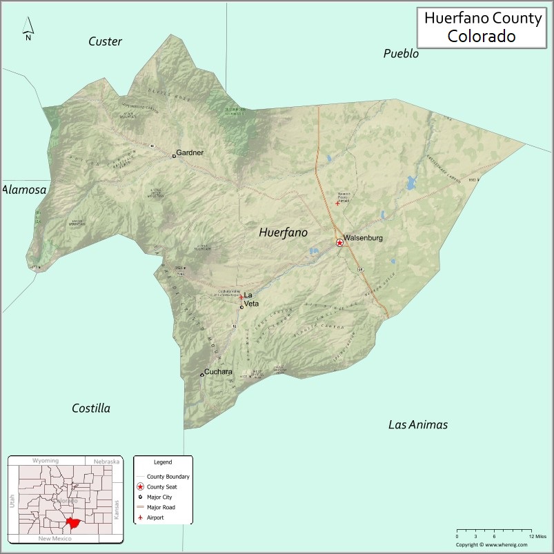
About Huerfano County Map, Colorado: The map showing the county boundary, county seat, major cities, highways, water bodies and neighbouring counties.
Most Viewed Links
Map of Huerfano County, Colorado
Huerfano County is a county located in the U.S. state of Colorado. It's county seat is Walsenburg. As per 2020 census, the population of Huerfano County is 6920 people and population density is square miles. According to the United States Census Bureau, the county has a total area of 1,592.37 sq mi (4,124 km2). Huerfano County was established on -13938.
Huerfano County Facts
| Continent | North America |
| Country | United States |
| State | Colorado |
| County Seat | Walsenburg |
| Largest City/Town | Walsenburg |
| Established | 1861 |
| Total Area | 1,593 sq mi (4,126 sq km) |
| Land Area | 1,590 sq mi (4,118 sq km) |
| Water Area | 3 sq mi (8 sq km) |
| Population | 6,820 (Census 2020) |
| Population Density | 4.3 people per sq mi |
| Time Zone | Mountain Time Zone (MST/MDT) |
| Major Highways | Interstate 25, US Highway 160, State Highway 69 |
| Major Rivers | Huerfano River, Cucharas River |
| Neighboring Counties | Pueblo County, Las Animas County, Costilla County, Alamosa County, Custer County, Saguache County |
| Famous For | Spanish Peaks, historic coal mining, ranching, and scenic mountain landscapes |
| Top Attractions | Spanish Peaks, Lathrop State Park, Cuchara Valley, Highway of Legends Scenic Byway |
| Official Website | Official Website |
About Huerfano County, Colorado
Huerfano County is located in southern Colorado in the United States and was established in 1861 as one of the original counties of the Colorado Territory. The county seat and largest city is Walsenburg. The county is known for mountain scenery, ranching, coal mining history, the Spanish Peaks, and outdoor recreation opportunities.
Cities and Towns in Huerfano County, Colorado
| City/Town | Population (Census 2020) | Latitude & Longitude |
|---|---|---|
| Walsenburg (county seat) | 3,068 | 37.6242°N, 104.7803°W |
| La Veta | 862 | 37.5050°N, 105.0078°W |
| Cuchara | 177 | 37.3525°N, 105.1000°W |
| Gardner (CDP) | 116 | 37.7747°N, 105.1689°W |
| Badito (historic community) | Historic site | 37.7258°N, 105.0369°W |
| Farista (historic community) | Historic site | 37.5361°N, 104.9033°W |
| Red Wing (CDP) | 95 | 37.9039°N, 105.1572°W |
| Rye nearby communities | Regional area | 37.9175°N, 104.9406°W |
Golf Courses in Huerfano County, Colorado
| Golf Course | Location | Latitude & Longitude |
|---|---|---|
| Grandote Peaks Golf Club | La Veta | 37.5058°N, 104.9989°W |
| Lathrop State Park Golf Area | Walsenburg | 37.6453°N, 104.7797°W |
| Hollydot Golf Course | Colorado City nearby | 37.9506°N, 104.8344°W |
Roads and Highways in Huerfano County, Colorado
Major highways connect the county to southern Colorado cities, mountain valleys, and scenic recreation areas.
- Interstate 25 - major north-south interstate connecting Walsenburg with Pueblo and Trinidad
- US Highway 160 - east-west highway linking Walsenburg with La Veta Pass and the San Luis Valley
- Colorado State Highway 69 - scenic route connecting Walsenburg with Westcliffe and the Wet Mountain Valley
Neighboring Counties of Huerfano County
- Pueblo County (north)
- Custer County (northwest)
- Saguache County (west)
- Alamosa County (west)
- Costilla County (southwest)
- Las Animas County (east and south)
Top Attractions in Huerfano County, Colorado
The county offers a mix of natural and historical attractions.
- Spanish Peaks - iconic volcanic mountain peaks visible across southern Colorado
- Lathrop State Park - Colorado's first state park with lakes, camping, and golf facilities
- Highway of Legends Scenic Byway - scenic route featuring mountain views and historic towns
- Cuchara Valley Resort Area - mountain recreation destination with hiking and skiing history
- La Veta Historic District - art galleries, shops, and historic architecture
- Cucharas Pass and La Veta Pass - scenic mountain passes with panoramic views
- San Isabel National Forest access areas - hiking, camping, and wildlife viewing opportunities
- Walsenburg Mining Museum - exhibits covering coal mining and local history
- Great Dikes Trail System - geological formations surrounding the Spanish Peaks
- Dakota Wall climbing area - popular rock climbing destination near La Veta
- Huerfano Butte - volcanic landmark rising above the plains
- Francisco Fort Museum - historic adobe fort and pioneer history museum in La Veta
Distance from Huerfano County to Nearby Cities
The following distances are measured by road (driving).
- Walsenburg to Pueblo (Pueblo County), Colorado - 47 mi (76 km)
- Walsenburg to Trinidad (Las Animas County), Colorado - 49 mi (79 km)
- Walsenburg to Colorado Springs (El Paso County), Colorado - 95 mi (153 km)
- Walsenburg to Alamosa (Alamosa County), Colorado - 84 mi (135 km)
- Walsenburg to Westcliffe (Custer County), Colorado - 57 mi (92 km)
- Walsenburg to Canon City (Fremont County), Colorado - 78 mi (126 km)
- Walsenburg to Denver (Denver County), Colorado - 175 mi (282 km)
- Walsenburg to Salida (Chaffee County), Colorado - 103 mi (166 km)
- Walsenburg to Durango (La Plata County), Colorado - 196 mi (315 km)
- Walsenburg to Taos (Taos County), New Mexico - 118 mi (190 km)
- Walsenburg to Santa Fe (Santa Fe County), New Mexico - 196 mi (315 km)
- Walsenburg to Breckenridge (Summit County), Colorado - 165 mi (266 km)
FAQs about Huerfano County
Huerfano County is located in southern Colorado near the Spanish Peaks and Sangre de Cristo Mountains in the United States.
The population of Huerfano County was 6,820 according to the Census 2020.
Huerfano County is known for the Spanish Peaks, scenic mountain valleys, ranching, and coal mining history.
The county is served by Interstate 25, US Highway 160, and Colorado State Highway 69.
Popular attractions include the Spanish Peaks, Lathrop State Park, Cuchara Valley, and the Highway of Legends Scenic Byway.
References
- QuickFacts - U.S. Census Bureau
- United States Census Bureau
- United States Geological Survey (USGS)
- National Geodetic Survey
- Official Website
- Adams County Map
- Alamosa County Map
- Arapahoe County Map
- Archuleta County Map
- Baca County Map
- Bent County Map
- Boulder County Map
- Broomfield County Map
- Chaffee County Map
- Cheyenne County Map
- Clear Creek County Map
- Conejos County Map
- Costilla County Map
- Crowley County Map
- Custer County Map
- Delta County Map
- Denver County Map
- Dolores County Map
- Douglas County Map
- Eagle County Map
- Elbert County Map
- El Paso County Map
- Fremont County Map
- Garfield County Map
- Gilpin County Map
- Grand County Map
- Gunnison County Map
- Hinsdale County Map
- Huerfano County Map
- Jackson County Map
- Jefferson County Map
- Kiowa County Map
- Kit Carson County Map
- Lake County Map
- La Plata County Map
- Larimer County Map
- Las Animas County Map
- Lincoln County Map
- Logan County Map
- Mesa County Map
- Mineral County Map
- Moffat County Map
- Montezuma County Map
- Montrose County Map
- Morgan County Map
- Otero County Map
- Ouray County Map
- Park County Map
- Phillips County Map
- Pitkin County Map
- Prowers County Map
- Pueblo County Map
- Rio Blanco County Map
- Rio Grande County Map
- Routt County Map
- Saguache County Map
- San Juan County Map
- San Miguel County Map
- Sedgwick County Map
- Summit County Map
- Teller County Map
- Washington County Map
- Weld County Map
- Yuma County Map
- Alabama Counties
- Alaska boroughs
- Arizona Counties
- Arkansas Counties
- California County Map
- Colorado Counties
- Connecticut Counties
- Delaware Counties
- Florida County Map
- Georgia County Map
- Hawaii Counties
- Idaho Counties
- Illinois Counties
- Indiana Counties
- Iowa Counties
- Kansas Counties
- Kentucky Counties
- Louisiana Counties
- Maine Counties
- Maryland Counties
- Massachusetts Counties
- Michigan County Map
- Minnesota Counties
- Mississippi Counties
- Missouri Counties
- Montana Counties
- Nebraska Counties
- Nevada Counties
- New York Counties
- New Hampshire Counties
- New Jersey Counties
- New Mexico Counties
- North Carolina Counties
- North Dakota Counties
- Ohio County Map
- Oklahoma Counties
- Oregon Counties
- Pennsylvania Counties
- Rhode Island Counties
- South Carolina Counties
- South Dakota Counties
- Map of Tennessee
- Texas County Map
- Utah Counties
- Vermont Counties
- Virginia Counties
- Washington Counties
- West Virginia Counties
- Wisconsin Counties
- Wyoming Counties