Map of Montrose County - Montrose County is a county located in the U.S. state of Colorado. Montrose County Map showing cities, highways, important places and water bodies. Get Where is Montrose County located in the map, major cities in Montrose county, population, areas, and places of interest.
Map of Montrose County, Colorado
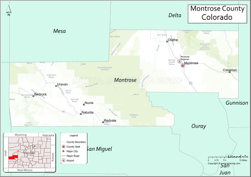
About Montrose County Map, Colorado: The map showing the county boundary, county seat, major cities, highways, water bodies and neighbouring counties.
Most Viewed Links
Map of Montrose County, Colorado
Montrose County is a county located in the U.S. state of Colorado. It's county seat is Montrose. As per 2020 census, the population of Montrose County is 43168 people and population density is square miles. According to the United States Census Bureau, the county has a total area of 2,246.43 sq mi (5,818 km2). Montrose County was established on -6166.
Montrose County Facts
| Continent | North America |
| Country | United States |
| State | Colorado |
| County Seat | Montrose |
| Largest City/Town | Montrose |
| Established | 1883 |
| Total Area | 2,243 sq mi (5,809 sq km) |
| Land Area | 2,241 sq mi (5,804 sq km) |
| Water Area | 2 sq mi (5 sq km) |
| Population | 42,679 (Census 2020) |
| Population Density | 19.0 people per sq mi |
| Time Zone | Mountain Time Zone (MST/MDT) |
| Major Highways | US Highway 50, US Highway 550, State Highway 90 |
| Major Rivers | Uncompahgre River, Gunnison River |
| Neighboring Counties | Mesa County, Delta County, Gunnison County, Ouray County, San Miguel County |
| Famous For | Black Canyon of the Gunnison, outdoor recreation, ranching, and western Colorado scenery |
| Top Attractions | Black Canyon of the Gunnison National Park, Ridgway nearby, Gunnison Gorge, Ute Indian Museum |
| Official Website | Official Website |
About Montrose County, Colorado
Montrose County is located in western Colorado in the United States and was established in 1883. The county seat and largest city is Montrose. The county is known for dramatic canyon scenery, outdoor recreation, agriculture, mountain landscapes, and its gateway access to Black Canyon of the Gunnison National Park.
Cities and Towns in Montrose County, Colorado
| City/Town | Population (Census 2020) | Latitude & Longitude |
|---|---|---|
| Montrose (county seat) | 20,291 | 38.4783°N, 107.8762°W |
| Naturita | 517 | 38.2189°N, 108.5681°W |
| Nucla | 711 | 38.2692°N, 108.5475°W |
| Olathe | 1,847 | 38.6044°N, 107.9839°W |
| Paradox (community) | Rural area | 38.3700°N, 108.9631°W |
| Cimarron (historic site) | Historic area | 38.4428°N, 107.5572°W |
| Colona (CDP) | 500 | 38.3306°N, 107.7756°W |
| Maher (community) | Rural area | 38.4625°N, 108.0439°W |
Golf Courses in Montrose County, Colorado
| Golf Course | Location | Latitude & Longitude |
|---|---|---|
| The Bridges Golf & Country Club | Montrose | 38.4517°N, 107.8636°W |
| Black Canyon Golf Course | Montrose | 38.4700°N, 107.8750°W |
| Cobble Creek Golf Community | Montrose | 38.4403°N, 107.8597°W |
| Devil's Thumb Golf Club | Delta nearby | 38.7392°N, 108.0672°W |
Roads and Highways in Montrose County, Colorado
Major highways connect the county to western Colorado mountain regions and recreation destinations.
- US Highway 50 - major east-west highway connecting Montrose with Grand Junction and Gunnison
- US Highway 550 - scenic north-south route linking Montrose with Ouray, Durango, and Ridgway
- Colorado State Highway 90 - route serving western Montrose County and Paradox Valley
Neighboring Counties of Montrose County
- Mesa County (northwest)
- Delta County (north)
- Gunnison County (east)
- Ouray County (south)
- San Miguel County (southwest)
Top Attractions in Montrose County, Colorado
The county offers a mix of scenic, recreational, and cultural attractions.
- Black Canyon of the Gunnison National Park - dramatic canyon known for steep cliffs and scenic overlooks
- Gunnison Gorge National Conservation Area - hiking, rafting, and fishing destination
- Ute Indian Museum - museum dedicated to Ute tribal history and culture
- Downtown Montrose - restaurants, shops, and western Colorado cultural attractions
- Ridgway State Park nearby - boating, camping, and mountain recreation area
- San Juan Mountains access routes - scenic drives and outdoor recreation opportunities
- Paradox Valley and Unaweep region - unique canyon and desert landscapes
- Curecanti National Recreation Area nearby - reservoir recreation and fishing destination
- Chipeta Lake State Wildlife Area - wildlife viewing and fishing area
- Historic Denver & Rio Grande railroad sites - transportation history landmarks
- Ouray and Telluride scenic routes nearby - mountain tourism and alpine scenery
- Uncompahgre River recreation trails - walking, biking, and fishing opportunities
Distance from Montrose County to Nearby Cities
The following distances are measured by road (driving).
- Montrose to Grand Junction (Mesa County), Colorado - 65 mi (105 km)
- Montrose to Gunnison (Gunnison County), Colorado - 65 mi (105 km)
- Montrose to Ouray (Ouray County), Colorado - 36 mi (58 km)
- Montrose to Telluride (San Miguel County), Colorado - 68 mi (109 km)
- Montrose to Durango (La Plata County), Colorado - 129 mi (208 km)
- Montrose to Aspen (Pitkin County), Colorado - 146 mi (235 km)
- Montrose to Denver (Denver County), Colorado - 290 mi (467 km)
- Montrose to Moab (Grand County), Utah - 122 mi (196 km)
- Montrose to Colorado Springs (El Paso County), Colorado - 341 mi (549 km)
- Montrose to Salt Lake City (Salt Lake County), Utah - 355 mi (571 km)
- Montrose to Cortez (Montezuma County), Colorado - 122 mi (196 km)
- Montrose to Las Vegas (Clark County), Nevada - 521 mi (838 km)
FAQs about Montrose County
Montrose County is located in western Colorado near the San Juan Mountains in the United States.
The population of Montrose County was 42,679 according to the Census 2020.
Montrose County is known for Black Canyon of the Gunnison National Park, outdoor recreation, and western Colorado mountain scenery.
The county is served by US Highway 50, US Highway 550, and Colorado State Highway 90.
Popular attractions include Black Canyon of the Gunnison National Park, Gunnison Gorge, Ridgway State Park, and the Ute Indian Museum.
References
- QuickFacts - U.S. Census Bureau
- United States Census Bureau
- United States Geological Survey (USGS)
- National Geodetic Survey
- Official Website
- Adams County Map
- Alamosa County Map
- Arapahoe County Map
- Archuleta County Map
- Baca County Map
- Bent County Map
- Boulder County Map
- Broomfield County Map
- Chaffee County Map
- Cheyenne County Map
- Clear Creek County Map
- Conejos County Map
- Costilla County Map
- Crowley County Map
- Custer County Map
- Delta County Map
- Denver County Map
- Dolores County Map
- Douglas County Map
- Eagle County Map
- Elbert County Map
- El Paso County Map
- Fremont County Map
- Garfield County Map
- Gilpin County Map
- Grand County Map
- Gunnison County Map
- Hinsdale County Map
- Huerfano County Map
- Jackson County Map
- Jefferson County Map
- Kiowa County Map
- Kit Carson County Map
- Lake County Map
- La Plata County Map
- Larimer County Map
- Las Animas County Map
- Lincoln County Map
- Logan County Map
- Mesa County Map
- Mineral County Map
- Moffat County Map
- Montezuma County Map
- Montrose County Map
- Morgan County Map
- Otero County Map
- Ouray County Map
- Park County Map
- Phillips County Map
- Pitkin County Map
- Prowers County Map
- Pueblo County Map
- Rio Blanco County Map
- Rio Grande County Map
- Routt County Map
- Saguache County Map
- San Juan County Map
- San Miguel County Map
- Sedgwick County Map
- Summit County Map
- Teller County Map
- Washington County Map
- Weld County Map
- Yuma County Map
- Alabama Counties
- Alaska boroughs
- Arizona Counties
- Arkansas Counties
- California County Map
- Colorado Counties
- Connecticut Counties
- Delaware Counties
- Florida County Map
- Georgia County Map
- Hawaii Counties
- Idaho Counties
- Illinois Counties
- Indiana Counties
- Iowa Counties
- Kansas Counties
- Kentucky Counties
- Louisiana Counties
- Maine Counties
- Maryland Counties
- Massachusetts Counties
- Michigan County Map
- Minnesota Counties
- Mississippi Counties
- Missouri Counties
- Montana Counties
- Nebraska Counties
- Nevada Counties
- New York Counties
- New Hampshire Counties
- New Jersey Counties
- New Mexico Counties
- North Carolina Counties
- North Dakota Counties
- Ohio County Map
- Oklahoma Counties
- Oregon Counties
- Pennsylvania Counties
- Rhode Island Counties
- South Carolina Counties
- South Dakota Counties
- Map of Tennessee
- Texas County Map
- Utah Counties
- Vermont Counties
- Virginia Counties
- Washington Counties
- West Virginia Counties
- Wisconsin Counties
- Wyoming Counties