Map of Baca County - Baca County is a county located in the U.S. state of Colorado. Baca County Map showing cities, highways, important places and water bodies. Get Where is Baca County located in the map, major cities in Baca county, population, areas, and places of interest.
Map of Baca County, Colorado
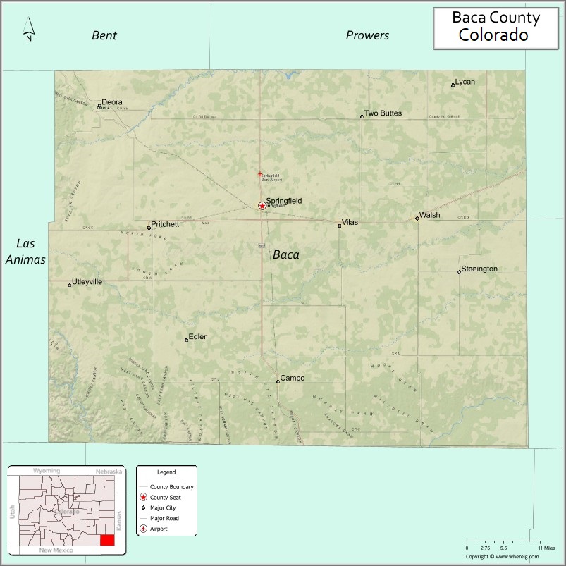
About Baca County Map, Colorado: The map showing the county boundary, county seat, major cities, highways, water bodies and neighbouring counties.
Most Viewed Links
Map of Baca County, Colorado
Baca County is a county located in the U.S. state of Colorado. It's county seat is Springfield. As per 2020 census, the population of Baca County is 3514 people and population density is square miles. According to the United States Census Bureau, the county has a total area of 2,558.48 sq mi (6,626 km2). Baca County was established on -3910.
Baca County Facts
| Continent | North America |
| Country | United States |
| State | Colorado |
| County Seat | Springfield |
| Largest City/Town | Springfield |
| Established | 1889 |
| Total Area | 2,557 sq mi (6,622 sq km) |
| Land Area | 2,554 sq mi (6,615 sq km) |
| Water Area | 2.6 sq mi (7 sq km) |
| Population | 3,506 (Census 2020) |
| Population Density | 1.4 people per sq mi |
| Time Zone | Mountain Time Zone (MST/MDT) |
| Major Highways | US Highway 287, US Highway 385, State Highway 116 |
| Major Rivers | Cimarron River, Two Butte Creek |
| Neighboring Counties | Prowers County, Las Animas County, Morton County (Kansas), Stanton County (Kansas), Cimarron County (Oklahoma), Union County (New Mexico) |
| Famous For | Comanche National Grassland, farming, ranching, prairie landscapes, and dinosaur tracks |
| Top Attractions | Comanche National Grassland, Picture Canyon, Two Buttes Reservoir, Baca County Museum |
| Official Website | Official Website |
About Baca County, Colorado
Baca County is located in the southeastern corner of Colorado in the United States and was established in 1889. The county seat and largest town is Springfield. The county is known for its open prairie landscapes, agricultural economy, historic trails, and outdoor recreation areas across the High Plains region.
Cities and Towns in Baca County, Colorado
| City/Town | Population (Census 2020) | Latitude & Longitude |
|---|---|---|
| Springfield (county seat) | 1,325 | 37.4081°N, 102.6149°W |
| Campo | 103 | 37.1042°N, 102.5794°W |
| Pritchett | 112 | 37.2867°N, 102.8594°W |
| Vilas | 98 | 37.3747°N, 102.4467°W |
| Walsh | 543 | 37.3878°N, 102.2781°W |
| Stonington (CDP) | 32 | 37.1539°N, 102.6906°W |
| Two Buttes (CDP) | 43 | 37.5647°N, 102.3925°W |
Golf Courses in Baca County, Colorado
| Golf Course | Location | Latitude & Longitude |
|---|---|---|
| Springfield Golf Club | Springfield | 37.3964°N, 102.6067°W |
| Walsh Community Golf Course | Walsh | 37.3847°N, 102.2789°W |
Roads and Highways in Baca County, Colorado
Major highways connect the county to nearby plains communities and neighboring states.
- US Highway 287 - north-south highway connecting Springfield with Lamar and Oklahoma
- US Highway 385 - route connecting Baca County with Kansas, New Mexico, and southeastern Colorado
- Colorado State Highway 116 - regional route connecting Springfield with Pritchett and Two Buttes
Neighboring Counties of Baca County
- Prowers County (north)
- Las Animas County (west)
- Morton County, Kansas (east)
- Stanton County, Kansas (northeast)
- Cimarron County, Oklahoma (south)
- Union County, New Mexico (southwest)
Top Attractions in Baca County, Colorado
The county offers a mix of natural and historical attractions.
- Comanche National Grassland - vast grassland area known for hiking, camping, and wildlife viewing
- Picture Canyon - scenic canyon featuring Native American rock art and hiking trails
- Two Buttes Reservoir - reservoir popular for fishing, boating, and birdwatching
- Baca County Museum - local history museum featuring pioneer and ranching exhibits
- Vogel Canyon - canyon area with historic wagon trail ruts and petroglyphs
- Carrizo Canyon - rugged canyon landscape with geological formations and trails
- Santa Fe Trail Historic Sites - historic trail locations connected to western migration
- Campo Depot Museum - small railroad museum highlighting local rail history
- Cimarron Heritage Center - regional heritage exhibits and cultural displays
- Springfield Community Park - public recreation area with picnic and sports facilities
Distance from Baca County to Nearby Cities
The following distances are measured by road (driving).
- Springfield to Lamar (Prowers County), Colorado - 74 mi (119 km)
- Springfield to Trinidad (Las Animas County), Colorado - 146 mi (235 km)
- Springfield to Pueblo (Pueblo County), Colorado - 213 mi (343 km)
- Springfield to Colorado Springs (El Paso County), Colorado - 230 mi (370 km)
- Springfield to Denver (Denver County), Colorado - 336 mi (541 km)
- Springfield to Boise City (Cimarron County), Oklahoma - 33 mi (53 km)
- Springfield to Garden City (Finney County), Kansas - 149 mi (240 km)
- Springfield to Liberal (Seward County), Kansas - 92 mi (148 km)
- Springfield to Clayton (Union County), New Mexico - 88 mi (142 km)
- Springfield to Dodge City (Ford County), Kansas - 187 mi (301 km)
- Springfield to La Junta (Otero County), Colorado - 135 mi (217 km)
- Springfield to Raton (Colfax County), New Mexico - 124 mi (200 km)
FAQs about Baca County
Baca County is located in southeastern Colorado along the borders of Kansas, Oklahoma, and New Mexico.
The population of Baca County was 3,506 according to the Census 2020.
Baca County is known for prairie landscapes, ranching, Comanche National Grassland, and historic trail sites.
The county is served by US Highway 287, US Highway 385, and Colorado State Highway 116.
Yes, Baca County has golf facilities including Springfield Golf Club and Walsh Community Golf Course.
References
- QuickFacts - U.S. Census Bureau
- United States Census Bureau
- United States Geological Survey (USGS)
- National Geodetic Survey
- Official County Website
- Adams County Map
- Alamosa County Map
- Arapahoe County Map
- Archuleta County Map
- Baca County Map
- Bent County Map
- Boulder County Map
- Broomfield County Map
- Chaffee County Map
- Cheyenne County Map
- Clear Creek County Map
- Conejos County Map
- Costilla County Map
- Crowley County Map
- Custer County Map
- Delta County Map
- Denver County Map
- Dolores County Map
- Douglas County Map
- Eagle County Map
- Elbert County Map
- El Paso County Map
- Fremont County Map
- Garfield County Map
- Gilpin County Map
- Grand County Map
- Gunnison County Map
- Hinsdale County Map
- Huerfano County Map
- Jackson County Map
- Jefferson County Map
- Kiowa County Map
- Kit Carson County Map
- Lake County Map
- La Plata County Map
- Larimer County Map
- Las Animas County Map
- Lincoln County Map
- Logan County Map
- Mesa County Map
- Mineral County Map
- Moffat County Map
- Montezuma County Map
- Montrose County Map
- Morgan County Map
- Otero County Map
- Ouray County Map
- Park County Map
- Phillips County Map
- Pitkin County Map
- Prowers County Map
- Pueblo County Map
- Rio Blanco County Map
- Rio Grande County Map
- Routt County Map
- Saguache County Map
- San Juan County Map
- San Miguel County Map
- Sedgwick County Map
- Summit County Map
- Teller County Map
- Washington County Map
- Weld County Map
- Yuma County Map
- Alabama Counties
- Alaska boroughs
- Arizona Counties
- Arkansas Counties
- California County Map
- Colorado Counties
- Connecticut Counties
- Delaware Counties
- Florida County Map
- Georgia County Map
- Hawaii Counties
- Idaho Counties
- Illinois Counties
- Indiana Counties
- Iowa Counties
- Kansas Counties
- Kentucky Counties
- Louisiana Counties
- Maine Counties
- Maryland Counties
- Massachusetts Counties
- Michigan County Map
- Minnesota Counties
- Mississippi Counties
- Missouri Counties
- Montana Counties
- Nebraska Counties
- Nevada Counties
- New York Counties
- New Hampshire Counties
- New Jersey Counties
- New Mexico Counties
- North Carolina Counties
- North Dakota Counties
- Ohio County Map
- Oklahoma Counties
- Oregon Counties
- Pennsylvania Counties
- Rhode Island Counties
- South Carolina Counties
- South Dakota Counties
- Map of Tennessee
- Texas County Map
- Utah Counties
- Vermont Counties
- Virginia Counties
- Washington Counties
- West Virginia Counties
- Wisconsin Counties
- Wyoming Counties