Map of Mineral County - Mineral County is a county located in the U.S. state of Colorado. Mineral County Map showing cities, highways, important places and water bodies. Get Where is Mineral County located in the map, major cities in Mineral county, population, areas, and places of interest.
Map of Mineral County, Colorado
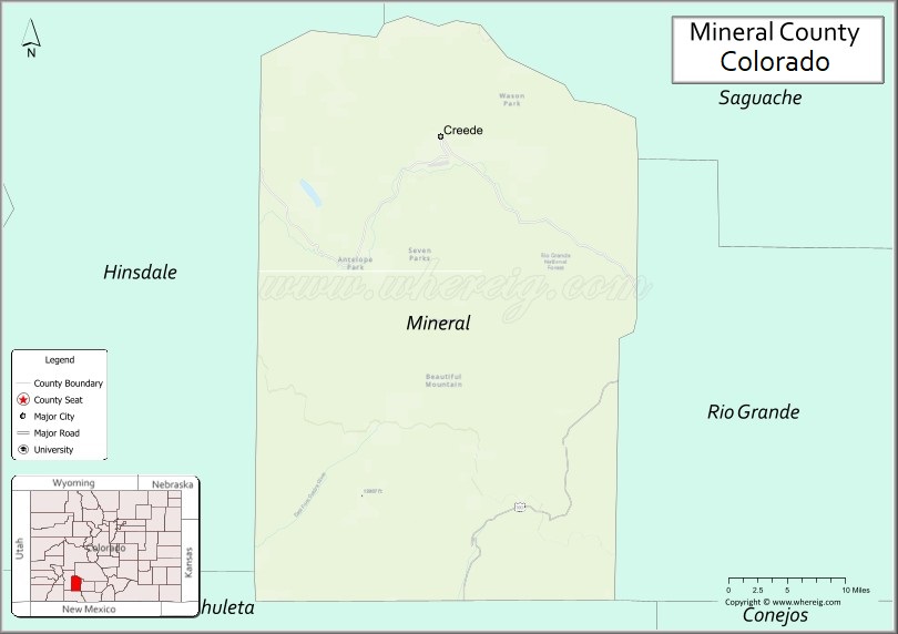
About Mineral County Map, Colorado: The map showing the county boundary, county seat, major cities, highways, water bodies and neighbouring counties.
Most Viewed Links
Map of Mineral County, Colorado
Mineral County is a county located in the U.S. state of Colorado. It's county seat is Creede. As per 2020 census, the population of Mineral County is 924 people and population density is square miles. According to the United States Census Bureau, the county has a total area of 878.16 sq mi (2,274 km2). Mineral County was established on -2469.
Mineral County Facts
| Continent | North America |
| Country | United States |
| State | Colorado |
| County Seat | Creede |
| Largest City/Town | Creede |
| Established | 1893 |
| Total Area | 878 sq mi (2,274 sq km) |
| Land Area | 877 sq mi (2,271 sq km) |
| Water Area | 1 sq mi (3 sq km) |
| Population | 865 (Census 2020) |
| Population Density | 1.0 people per sq mi |
| Time Zone | Mountain Time Zone (MST/MDT) |
| Major Highways | State Highway 149 |
| Major Rivers | Rio Grande, Willow Creek |
| Neighboring Counties | Rio Grande County, Hinsdale County, Saguache County |
| Famous For | Creede, silver mining history, San Juan Mountains, and outdoor recreation |
| Top Attractions | Creede Historic District, Bachelor Loop, Rio Grande headwaters, Wheeler Geologic Area |
| Official Website | Official Website |
About Mineral County, Colorado
Mineral County is located in south-central Colorado in the United States and was established in 1893. The county seat and largest town is Creede. The county is known for silver mining history, mountain scenery, fishing streams, alpine wilderness, and recreation opportunities in the San Juan Mountains.
Cities and Communities in Mineral County, Colorado
| City/Town | Population (Census 2020) | Latitude & Longitude |
|---|---|---|
| Creede (county seat) | 290 | 37.8492°N, 106.9264°W |
| Spar City (historic community) | Historic site | 37.8525°N, 106.9297°W |
| North Clear Creek Falls area | Scenic area | 37.8981°N, 106.9406°W |
| Bachelor historic mining district | Historic area | 37.8583°N, 106.9500°W |
| Wagon Wheel Gap | Historic resort area | 37.7711°N, 106.8297°W |
| Rio Grande Reservoir area | Mountain recreation region | 37.7167°N, 107.2667°W |
Golf Courses in Mineral County, Colorado
| Golf Course | Location | Latitude & Longitude |
|---|---|---|
| Rio Grande Club & Resort | South Fork nearby | 37.6669°N, 106.6372°W |
| Monte Vista Golf Club | Monte Vista nearby | 37.5792°N, 106.1483°W |
| Pagosa Springs Golf Club | Pagosa Springs nearby | 37.2694°N, 107.0372°W |
Roads and Highways in Mineral County, Colorado
Major highways connect the county to mountain recreation areas and nearby San Luis Valley communities.
- Colorado State Highway 149 - scenic Silver Thread Byway route connecting Creede with Lake City and South Fork
Neighboring Counties of Mineral County
- Hinsdale County (northwest)
- Saguache County (north and northeast)
- Rio Grande County (south and southeast)
Top Attractions in Mineral County, Colorado
The county offers a mix of historical, scenic, and outdoor recreation attractions.
- Creede Historic District - preserved mining town with shops, galleries, and historic buildings
- Bachelor Loop Scenic Drive - mountain route featuring historic mining sites and panoramic views
- Wheeler Geologic Area - unusual volcanic rock formations and hiking destination
- Rio Grande headwaters region - fishing, rafting, and scenic mountain recreation
- North Clear Creek Falls - dramatic waterfall accessible from the Silver Thread Byway
- Creede Repertory Theatre - nationally recognized live theater venue in downtown Creede
- Rio Grande National Forest - hiking, camping, and wildlife viewing opportunities
- Historic Mining Museums - exhibits covering silver mining and frontier history
- San Juan Mountain trails - hiking, ATV routes, and alpine recreation areas
- Wagon Wheel Gap Hot Springs historic area - former resort and recreation destination
- Rio Grande Reservoir - boating, fishing, and camping recreation area
- Silver Thread Scenic Byway - scenic mountain highway connecting Creede with Lake City
Distance from Mineral County to Nearby Cities
The following distances are measured by road (driving).
- Creede to South Fork (Rio Grande County), Colorado - 21 mi (34 km)
- Creede to Lake City (Hinsdale County), Colorado - 54 mi (87 km)
- Creede to Alamosa (Alamosa County), Colorado - 82 mi (132 km)
- Creede to Durango (La Plata County), Colorado - 128 mi (206 km)
- Creede to Gunnison (Gunnison County), Colorado - 118 mi (190 km)
- Creede to Pagosa Springs (Archuleta County), Colorado - 76 mi (122 km)
- Creede to Salida (Chaffee County), Colorado - 118 mi (190 km)
- Creede to Colorado Springs (El Paso County), Colorado - 210 mi (338 km)
- Creede to Denver (Denver County), Colorado - 261 mi (420 km)
- Creede to Santa Fe (Santa Fe County), New Mexico - 203 mi (327 km)
- Creede to Grand Junction (Mesa County), Colorado - 227 mi (365 km)
- Creede to Taos (Taos County), New Mexico - 138 mi (222 km)
FAQs about Mineral County
Mineral County is located in south-central Colorado within the San Juan Mountains region of the United States.
The population of Mineral County was 865 according to the Census 2020.
Mineral County is known for Creede, silver mining history, alpine scenery, and outdoor recreation.
The county is primarily served by Colorado State Highway 149, also known as the Silver Thread Byway.
Popular attractions include the Creede Historic District, Bachelor Loop Scenic Drive, Wheeler Geologic Area, and Rio Grande recreation areas.
References
- QuickFacts - U.S. Census Bureau
- United States Census Bureau
- United States Geological Survey (USGS)
- National Geodetic Survey
- Official Website
- Adams County Map
- Alamosa County Map
- Arapahoe County Map
- Archuleta County Map
- Baca County Map
- Bent County Map
- Boulder County Map
- Broomfield County Map
- Chaffee County Map
- Cheyenne County Map
- Clear Creek County Map
- Conejos County Map
- Costilla County Map
- Crowley County Map
- Custer County Map
- Delta County Map
- Denver County Map
- Dolores County Map
- Douglas County Map
- Eagle County Map
- Elbert County Map
- El Paso County Map
- Fremont County Map
- Garfield County Map
- Gilpin County Map
- Grand County Map
- Gunnison County Map
- Hinsdale County Map
- Huerfano County Map
- Jackson County Map
- Jefferson County Map
- Kiowa County Map
- Kit Carson County Map
- Lake County Map
- La Plata County Map
- Larimer County Map
- Las Animas County Map
- Lincoln County Map
- Logan County Map
- Mesa County Map
- Mineral County Map
- Moffat County Map
- Montezuma County Map
- Montrose County Map
- Morgan County Map
- Otero County Map
- Ouray County Map
- Park County Map
- Phillips County Map
- Pitkin County Map
- Prowers County Map
- Pueblo County Map
- Rio Blanco County Map
- Rio Grande County Map
- Routt County Map
- Saguache County Map
- San Juan County Map
- San Miguel County Map
- Sedgwick County Map
- Summit County Map
- Teller County Map
- Washington County Map
- Weld County Map
- Yuma County Map
- Alabama Counties
- Alaska boroughs
- Arizona Counties
- Arkansas Counties
- California County Map
- Colorado Counties
- Connecticut Counties
- Delaware Counties
- Florida County Map
- Georgia County Map
- Hawaii Counties
- Idaho Counties
- Illinois Counties
- Indiana Counties
- Iowa Counties
- Kansas Counties
- Kentucky Counties
- Louisiana Counties
- Maine Counties
- Maryland Counties
- Massachusetts Counties
- Michigan County Map
- Minnesota Counties
- Mississippi Counties
- Missouri Counties
- Montana Counties
- Nebraska Counties
- Nevada Counties
- New York Counties
- New Hampshire Counties
- New Jersey Counties
- New Mexico Counties
- North Carolina Counties
- North Dakota Counties
- Ohio County Map
- Oklahoma Counties
- Oregon Counties
- Pennsylvania Counties
- Rhode Island Counties
- South Carolina Counties
- South Dakota Counties
- Map of Tennessee
- Texas County Map
- Utah Counties
- Vermont Counties
- Virginia Counties
- Washington Counties
- West Virginia Counties
- Wisconsin Counties
- Wyoming Counties