Map of Conejos County - Conejos County is a county located in the U.S. state of Colorado. Conejos County Map showing cities, highways, important places and water bodies. Get Where is Conejos County located in the map, major cities in Conejos county, population, areas, and places of interest.
Map of Conejos County, Colorado
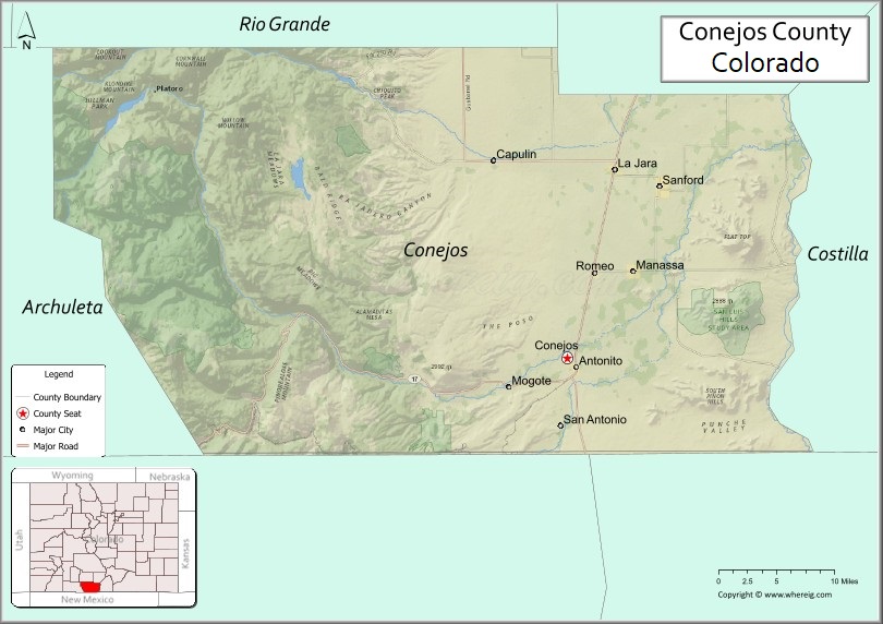
About Conejos County Map, Colorado: The map showing the county boundary, county seat, major cities, highways, water bodies and neighbouring counties.
Most Viewed Links
Map of Conejos County, Colorado
Conejos County is a county located in the U.S. state of Colorado. It's county seat is Conejos. As per 2020 census, the population of Conejos County is 7612 people and population density is square miles. According to the United States Census Bureau, the county has a total area of 1,290.22 sq mi (3,342 km2). Conejos County was established on -13938.
Conejos County Facts
| Continent | North America |
| Country | United States |
| State | Colorado |
| County Seat | Conejos |
| Largest City/Town | Antonito |
| Established | 1861 |
| Total Area | 1,291 sq mi (3,344 sq km) |
| Land Area | 1,287 sq mi (3,334 sq km) |
| Water Area | 4 sq mi (10 sq km) |
| Population | 7,453 (Census 2020) |
| Population Density | 5.8 people per sq mi |
| Time Zone | Mountain Time Zone (MST/MDT) |
| Major Highways | US Highway 285, US Highway 285 Business, State Highway 17 |
| Major Rivers | Conejos River, Rio Grande |
| Neighboring Counties | Alamosa County, Rio Grande County, Archuleta County, Costilla County, Rio Arriba County (New Mexico) |
| Famous For | Cumbres and Toltec Scenic Railroad, San Luis Valley, historic Hispanic settlements, and mountain scenery |
| Top Attractions | Cumbres and Toltec Scenic Railroad, Conejos River, Rio Grande National Forest, Antonito heritage sites |
| Official Website | Official Website |
About Conejos County, Colorado
Conejos County is located in south-central Colorado in the United States and was established in 1861 as one of the original counties of the Colorado Territory. The county seat is Conejos, while Antonito is the largest town. The county is known for its deep Hispanic heritage, mountain valleys, rivers, historic churches, and scenic railroad routes through the San Luis Valley region.
Cities and Towns in Conejos County, Colorado
| City/Town | Population (Census 2020) | Latitude & Longitude |
|---|---|---|
| Conejos (county seat) | 58 | 37.0881°N, 106.0217°W |
| Antonito | 726 | 37.0797°N, 106.0092°W |
| La Jara | 728 | 37.2747°N, 105.9600°W |
| Manassa | 991 | 37.1731°N, 105.9378°W |
| Romeo | 302 | 37.1722°N, 105.9872°W |
| Sanford | 887 | 37.2558°N, 105.8997°W |
| Capulin (CDP) | 177 | 37.2867°N, 106.1169°W |
| Guadalupe (CDP) | 44 | 37.1281°N, 105.8792°W |
| La Sauses (CDP) | 24 | 37.3150°N, 105.7456°W |
| Mogote (CDP) | 127 | 37.0592°N, 106.1842°W |
| Ortiz (CDP) | 52 | 37.0025°N, 105.9483°W |
Golf Courses in Conejos County, Colorado
| Golf Course | Location | Latitude & Longitude |
|---|---|---|
| Cumbres Valley Golf Course | Antonito | 37.0803°N, 106.0189°W |
| San Luis Valley Regional Golf Area | La Jara | 37.2736°N, 105.9611°W |
Roads and Highways in Conejos County, Colorado
Major highways connect the county to nearby San Luis Valley communities and northern New Mexico.
- US Highway 285 - north-south route connecting Conejos County with Alamosa and New Mexico
- US Highway 285 Business - local route serving Antonito and nearby communities
- Colorado State Highway 17 - scenic route connecting the county with the San Luis Valley and Costilla County
Neighboring Counties of Conejos County
- Rio Grande County (north)
- Alamosa County (northwest)
- Archuleta County (west)
- Costilla County (east)
- Rio Arriba County, New Mexico (south)
Top Attractions in Conejos County, Colorado
The county offers a mix of natural and historical attractions.
- Cumbres and Toltec Scenic Railroad - historic steam railroad running through mountain scenery between Colorado and New Mexico
- Rio Grande National Forest - large forest area with hiking, camping, and fishing opportunities
- Conejos River - scenic river popular for fishing, rafting, and outdoor recreation
- Old San Acacio Church - one of the oldest churches in Colorado with historic adobe architecture
- Antonito Historic District - historic community featuring heritage buildings and railroad culture
- Los Caminos Antiguos Scenic Byway - scenic driving route through historic San Luis Valley communities
- Platoro Reservoir - mountain reservoir popular for boating and fishing
- Manassa Pioneer Heritage Museum - museum dedicated to local pioneer and agricultural history
- Cumbres Pass - scenic mountain pass with panoramic views and railroad access
- San Luis Valley Farmlands - scenic agricultural landscapes surrounded by mountain ranges
- La Jara Reservoir Wildlife Area - fishing and birdwatching area near La Jara
- Fox Creek Wildlife Area - outdoor recreation and wildlife habitat destination
Distance from Conejos County to Nearby Cities
The following distances are measured by road (driving).
- Conejos to Alamosa (Alamosa County), Colorado - 33 mi (53 km)
- Conejos to Monte Vista (Rio Grande County), Colorado - 38 mi (61 km)
- Conejos to Pagosa Springs (Archuleta County), Colorado - 84 mi (135 km)
- Conejos to Taos (Taos County), New Mexico - 83 mi (134 km)
- Conejos to Santa Fe (Santa Fe County), New Mexico - 135 mi (217 km)
- Conejos to Durango (La Plata County), Colorado - 142 mi (229 km)
- Conejos to Salida (Chaffee County), Colorado - 141 mi (227 km)
- Conejos to Colorado Springs (El Paso County), Colorado - 198 mi (319 km)
- Conejos to Pueblo (Pueblo County), Colorado - 154 mi (248 km)
- Conejos to Denver (Denver County), Colorado - 267 mi (430 km)
- Conejos to Chama (Rio Arriba County), New Mexico - 31 mi (50 km)
- Conejos to Walsenburg (Huerfano County), Colorado - 122 mi (196 km)
FAQs about Conejos County
Conejos County is located in south-central Colorado near the New Mexico border in the United States.
The population of Conejos County was 7,453 according to the Census 2020.
Conejos County is known for the Cumbres and Toltec Scenic Railroad, Hispanic heritage, mountain scenery, and the San Luis Valley.
The county is served by US Highway 285 and Colorado State Highway 17.
Yes, Conejos County has golf facilities and regional golf areas near Antonito and La Jara.
References
- QuickFacts - U.S. Census Bureau
- United States Census Bureau
- United States Geological Survey (USGS)
- National Geodetic Survey
- Official County Website
- Adams County Map
- Alamosa County Map
- Arapahoe County Map
- Archuleta County Map
- Baca County Map
- Bent County Map
- Boulder County Map
- Broomfield County Map
- Chaffee County Map
- Cheyenne County Map
- Clear Creek County Map
- Conejos County Map
- Costilla County Map
- Crowley County Map
- Custer County Map
- Delta County Map
- Denver County Map
- Dolores County Map
- Douglas County Map
- Eagle County Map
- Elbert County Map
- El Paso County Map
- Fremont County Map
- Garfield County Map
- Gilpin County Map
- Grand County Map
- Gunnison County Map
- Hinsdale County Map
- Huerfano County Map
- Jackson County Map
- Jefferson County Map
- Kiowa County Map
- Kit Carson County Map
- Lake County Map
- La Plata County Map
- Larimer County Map
- Las Animas County Map
- Lincoln County Map
- Logan County Map
- Mesa County Map
- Mineral County Map
- Moffat County Map
- Montezuma County Map
- Montrose County Map
- Morgan County Map
- Otero County Map
- Ouray County Map
- Park County Map
- Phillips County Map
- Pitkin County Map
- Prowers County Map
- Pueblo County Map
- Rio Blanco County Map
- Rio Grande County Map
- Routt County Map
- Saguache County Map
- San Juan County Map
- San Miguel County Map
- Sedgwick County Map
- Summit County Map
- Teller County Map
- Washington County Map
- Weld County Map
- Yuma County Map
- Alabama Counties
- Alaska boroughs
- Arizona Counties
- Arkansas Counties
- California County Map
- Colorado Counties
- Connecticut Counties
- Delaware Counties
- Florida County Map
- Georgia County Map
- Hawaii Counties
- Idaho Counties
- Illinois Counties
- Indiana Counties
- Iowa Counties
- Kansas Counties
- Kentucky Counties
- Louisiana Counties
- Maine Counties
- Maryland Counties
- Massachusetts Counties
- Michigan County Map
- Minnesota Counties
- Mississippi Counties
- Missouri Counties
- Montana Counties
- Nebraska Counties
- Nevada Counties
- New York Counties
- New Hampshire Counties
- New Jersey Counties
- New Mexico Counties
- North Carolina Counties
- North Dakota Counties
- Ohio County Map
- Oklahoma Counties
- Oregon Counties
- Pennsylvania Counties
- Rhode Island Counties
- South Carolina Counties
- South Dakota Counties
- Map of Tennessee
- Texas County Map
- Utah Counties
- Vermont Counties
- Virginia Counties
- Washington Counties
- West Virginia Counties
- Wisconsin Counties
- Wyoming Counties