Map of Mesa County - Mesa County is a county located in the U.S. state of Colorado. Mesa County Map showing cities, highways, important places and water bodies. Get Where is Mesa County located in the map, major cities in Mesa county, population, areas, and places of interest.
Map of Mesa County, Colorado
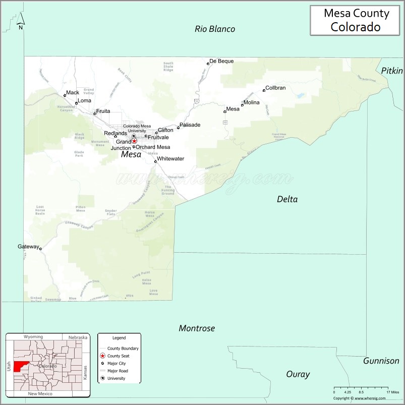
About Mesa County Map, Colorado: The map showing the county boundary, county seat, major cities, highways, water bodies and neighbouring counties.
Most Viewed Links
Map of Mesa County, Colorado
Mesa County is a county located in the U.S. state of Colorado. It's county seat is Grand Junction. As per 2020 census, the population of Mesa County is 157335 people and population density is square miles. According to the United States Census Bureau, the county has a total area of 3,345.69 sq mi (8,665 km2). Mesa County was established on -6163.
Mesa County Facts
| Continent | North America |
| Country | United States |
| State | Colorado |
| County Seat | Grand Junction |
| Largest City/Town | Grand Junction |
| Established | 1883 |
| Total Area | 3,341 sq mi (8,653 sq km) |
| Land Area | 3,329 sq mi (8,622 sq km) |
| Water Area | 12 sq mi (31 sq km) |
| Population | 155,703 (Census 2020) |
| Population Density | 46.8 people per sq mi |
| Time Zone | Mountain Time Zone (MST/MDT) |
| Major Highways | Interstate 70, US Highway 50, US Highway 6, State Highway 141 |
| Major Rivers | Colorado River, Gunnison River |
| Neighboring Counties | Garfield County, Delta County, Montrose County, Pitkin County, Grand County (UT) |
| Famous For | Colorado National Monument, Grand Junction, wineries, red rock landscapes, and outdoor recreation |
| Top Attractions | Colorado National Monument, Grand Mesa, Palisade wineries, Museum of the West |
| Official Website | Official Website |
About Mesa County, Colorado
Mesa County is located in western Colorado in the United States and was established in 1883. The county seat and largest city is Grand Junction. The county is known for red rock canyons, vineyards, outdoor recreation, mountain scenery, and its location along the Colorado River in the Grand Valley region.
Cities and Towns in Mesa County, Colorado
| City/Town | Population (Census 2020) | Latitude & Longitude |
|---|---|---|
| Grand Junction (county seat) | 65,560 | 39.0639°N, 108.5506°W |
| Fruita | 13,604 | 39.1589°N, 108.7289°W |
| Palisade | 2,644 | 39.1103°N, 108.3509°W |
| Clifton (CDP) | 20,413 | 39.0917°N, 108.4492°W |
| Orchard Mesa (CDP) | 6,000 | 39.0364°N, 108.5311°W |
| Collbran | 369 | 39.2419°N, 107.9608°W |
| De Beque | 504 | 39.3342°N, 108.2142°W |
| Mesa (community) | Historic area | 39.1631°N, 108.1328°W |
Golf Courses in Mesa County, Colorado
| Golf Course | Location | Latitude & Longitude |
|---|---|---|
| Redlands Mesa Golf Club | Grand Junction | 39.0506°N, 108.6047°W |
| Tiara Rado Golf Course | Grand Junction | 39.0342°N, 108.6131°W |
| Adobe Creek National Golf Course | Fruita | 39.1711°N, 108.7281°W |
| Battlement Mesa Golf Club | Parachute nearby | 39.4472°N, 108.0464°W |
Roads and Highways in Mesa County, Colorado
Major highways connect the county to western Colorado, Utah, and scenic recreation destinations.
- Interstate 70 - major interstate connecting Grand Junction with Denver and Utah
- US Highway 50 - route linking Grand Junction with Montrose and central Colorado
- US Highway 6 - historic highway serving communities along the Colorado River corridor
- Colorado State Highway 141 - scenic route through red rock canyons and western Colorado landscapes
Neighboring Counties of Mesa County
- Garfield County (east)
- Pitkin County (southeast)
- Delta County (south)
- Montrose County (southwest)
- Grand County, Utah (west)
Top Attractions in Mesa County, Colorado
The county offers a mix of natural, recreational, and cultural attractions.
- Colorado National Monument - dramatic red rock canyon landscape with scenic drives and hiking trails
- Grand Mesa - large flat-topped mountain area with lakes, forests, and outdoor recreation
- Palisade wineries and orchards - wine tasting, fruit farms, and agritourism attractions
- Downtown Grand Junction - shopping, restaurants, art galleries, and cultural events
- Fruita mountain biking trails - nationally known biking and outdoor recreation destination
- Museum of the West - museum covering western Colorado history and culture
- James M. Robb Colorado River State Park - riverside recreation and camping areas
- Rim Rock Drive - scenic roadway through Colorado National Monument
- Dominguez-Escalante National Conservation Area nearby - canyon hiking and desert scenery
- Powderhorn Mountain Resort - skiing and mountain recreation on Grand Mesa
- Palisade Peach Festival - annual event celebrating local agriculture and orchards
- Colorado River recreation areas - rafting, fishing, and kayaking opportunities
Distance from Mesa County to Nearby Cities
The following distances are measured by road (driving).
- Grand Junction to Montrose (Montrose County), Colorado - 65 mi (105 km)
- Grand Junction to Glenwood Springs (Garfield County), Colorado - 90 mi (145 km)
- Grand Junction to Moab (Grand County), Utah - 113 mi (182 km)
- Grand Junction to Denver (Denver County), Colorado - 247 mi (398 km)
- Grand Junction to Aspen (Pitkin County), Colorado - 125 mi (201 km)
- Grand Junction to Durango (La Plata County), Colorado - 164 mi (264 km)
- Grand Junction to Salt Lake City (Salt Lake County), Utah - 284 mi (457 km)
- Grand Junction to Colorado Springs (El Paso County), Colorado - 298 mi (480 km)
- Grand Junction to Vail (Eagle County), Colorado - 141 mi (227 km)
- Grand Junction to Fruita (Mesa County), Colorado - 12 mi (19 km)
- Grand Junction to Telluride (San Miguel County), Colorado - 129 mi (208 km)
- Grand Junction to Las Vegas (Clark County), Nevada - 524 mi (843 km)
FAQs about Mesa County
Mesa County is located in western Colorado along the Colorado River near the Utah border in the United States.
The population of Mesa County was 155,703 according to the Census 2020.
Mesa County is known for Colorado National Monument, wineries, red rock landscapes, and outdoor recreation.
The county is served by Interstate 70, US Highway 50, US Highway 6, and Colorado State Highway 141.
Popular attractions include Colorado National Monument, Grand Mesa, Palisade wineries, and downtown Grand Junction.
References
- QuickFacts - U.S. Census Bureau
- United States Census Bureau
- United States Geological Survey (USGS)
- National Geodetic Survey
- Official Website
- Adams County Map
- Alamosa County Map
- Arapahoe County Map
- Archuleta County Map
- Baca County Map
- Bent County Map
- Boulder County Map
- Broomfield County Map
- Chaffee County Map
- Cheyenne County Map
- Clear Creek County Map
- Conejos County Map
- Costilla County Map
- Crowley County Map
- Custer County Map
- Delta County Map
- Denver County Map
- Dolores County Map
- Douglas County Map
- Eagle County Map
- Elbert County Map
- El Paso County Map
- Fremont County Map
- Garfield County Map
- Gilpin County Map
- Grand County Map
- Gunnison County Map
- Hinsdale County Map
- Huerfano County Map
- Jackson County Map
- Jefferson County Map
- Kiowa County Map
- Kit Carson County Map
- Lake County Map
- La Plata County Map
- Larimer County Map
- Las Animas County Map
- Lincoln County Map
- Logan County Map
- Mesa County Map
- Mineral County Map
- Moffat County Map
- Montezuma County Map
- Montrose County Map
- Morgan County Map
- Otero County Map
- Ouray County Map
- Park County Map
- Phillips County Map
- Pitkin County Map
- Prowers County Map
- Pueblo County Map
- Rio Blanco County Map
- Rio Grande County Map
- Routt County Map
- Saguache County Map
- San Juan County Map
- San Miguel County Map
- Sedgwick County Map
- Summit County Map
- Teller County Map
- Washington County Map
- Weld County Map
- Yuma County Map
- Alabama Counties
- Alaska boroughs
- Arizona Counties
- Arkansas Counties
- California County Map
- Colorado Counties
- Connecticut Counties
- Delaware Counties
- Florida County Map
- Georgia County Map
- Hawaii Counties
- Idaho Counties
- Illinois Counties
- Indiana Counties
- Iowa Counties
- Kansas Counties
- Kentucky Counties
- Louisiana Counties
- Maine Counties
- Maryland Counties
- Massachusetts Counties
- Michigan County Map
- Minnesota Counties
- Mississippi Counties
- Missouri Counties
- Montana Counties
- Nebraska Counties
- Nevada Counties
- New York Counties
- New Hampshire Counties
- New Jersey Counties
- New Mexico Counties
- North Carolina Counties
- North Dakota Counties
- Ohio County Map
- Oklahoma Counties
- Oregon Counties
- Pennsylvania Counties
- Rhode Island Counties
- South Carolina Counties
- South Dakota Counties
- Map of Tennessee
- Texas County Map
- Utah Counties
- Vermont Counties
- Virginia Counties
- Washington Counties
- West Virginia Counties
- Wisconsin Counties
- Wyoming Counties