Map of Montezuma County - Montezuma County is a county located in the U.S. state of Colorado. Montezuma County Map showing cities, highways, important places and water bodies. Get Where is Montezuma County located in the map, major cities in Montezuma county, population, areas, and places of interest.
Map of Montezuma County, Colorado
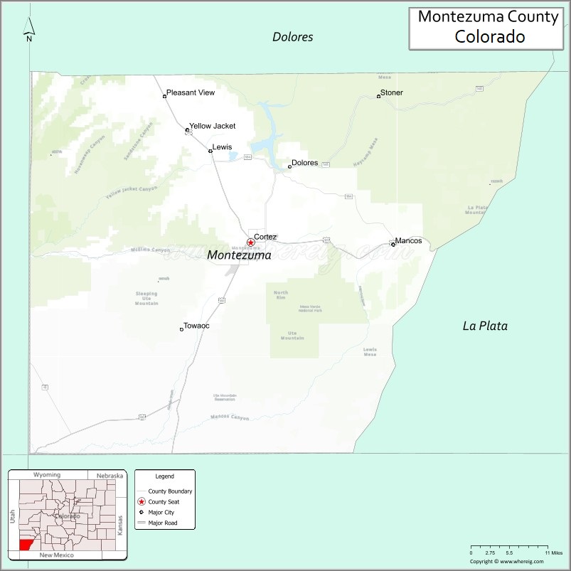
About Montezuma County Map, Colorado: The map showing the county boundary, county seat, major cities, highways, water bodies and neighbouring counties.
Most Viewed Links
Map of Montezuma County, Colorado
Montezuma County is a county located in the U.S. state of Colorado. It's county seat is Cortez. As per 2020 census, the population of Montezuma County is 26175 people and population density is square miles. According to the United States Census Bureau, the county has a total area of 2,035.80 sq mi (5,273 km2). Montezuma County was established on -3910.
Montezuma County Facts
| Continent | North America |
| Country | United States |
| State | Colorado |
| County Seat | Cortez |
| Largest City/Town | Cortez |
| Established | 1889 |
| Total Area | 2,040 sq mi (5,284 sq km) |
| Land Area | 2,030 sq mi (5,258 sq km) |
| Water Area | 10 sq mi (26 sq km) |
| Population | 26,069 (Census 2020) |
| Population Density | 12.8 people per sq mi |
| Time Zone | Mountain Time Zone (MST/MDT) |
| Major Highways | US Highway 160, US Highway 491, State Highway 145 |
| Major Rivers | Dolores River, Mancos River |
| Neighboring Counties | Dolores County, La Plata County, San Juan County (NM), McKinley County (NM), San Juan County (UT) |
| Famous For | Mesa Verde National Park, ancient Puebloan history, canyon landscapes, and outdoor recreation |
| Top Attractions | Mesa Verde National Park, Canyons of the Ancients, Hovenweep National Monument, Dolores River |
| Official Website | Official Website |
About Montezuma County, Colorado
Montezuma County is located in southwestern Colorado in the United States and was established in 1889. The county seat and largest city is Cortez. The county is known for archaeological sites, Native American history, scenic canyons, mountain views, and outdoor recreation near the Four Corners region.
Cities and Towns in Montezuma County, Colorado
| City/Town | Population (Census 2020) | Latitude & Longitude |
|---|---|---|
| Cortez (county seat) | 8,766 | 37.3489°N, 108.5859°W |
| Dolores | 936 | 37.4739°N, 108.5037°W |
| Mancos | 1,344 | 37.3442°N, 108.2895°W |
| Towaoc (CDP) | 1,089 | 37.2044°N, 108.7295°W |
| Lewis (community) | Rural area | 37.5247°N, 108.6656°W |
| Yellow Jacket (community) | Historic area | 37.5008°N, 108.7350°W |
| Battle Rock area | Historic site | 37.3481°N, 108.5886°W |
| Arriola (community) | Rural area | 37.3725°N, 108.7192°W |
Golf Courses in Montezuma County, Colorado
| Golf Course | Location | Latitude & Longitude |
|---|---|---|
| Conquistador Golf Course | Cortez | 37.3494°N, 108.5889°W |
| Hillcrest Golf Club | Durango nearby | 37.2981°N, 107.8742°W |
| Riverview Golf Course | Kirtland nearby, New Mexico | 36.7294°N, 108.3594°W |
Roads and Highways in Montezuma County, Colorado
Major highways connect the county to southwestern Colorado, Utah, and New Mexico.
- US Highway 160 - major east-west highway connecting Cortez with Durango and Utah
- US Highway 491 - north-south route linking Cortez with New Mexico and Monticello, Utah
- Colorado State Highway 145 - scenic highway connecting Cortez with Dolores and Telluride regions
Neighboring Counties of Montezuma County
- Dolores County (north)
- La Plata County (east)
- San Juan County, Utah (west)
- San Juan County, New Mexico (south)
- McKinley County, New Mexico (southwest)
Top Attractions in Montezuma County, Colorado
The county offers a mix of archaeological, natural, and recreational attractions.
- Mesa Verde National Park - UNESCO World Heritage Site known for ancient cliff dwellings
- Canyons of the Ancients National Monument - archaeological area containing thousands of historic sites
- Hovenweep National Monument nearby - ancient Puebloan ruins and desert landscapes
- Dolores River recreation areas - rafting, fishing, and canyon scenery
- Mesa Verde Visitor and Research Center - exhibits on regional archaeology and Native American history
- Historic Downtown Cortez - museums, restaurants, and local art galleries
- McPhee Reservoir - boating, fishing, and camping destination
- Ute Mountain Tribal Park nearby - guided tours of cultural and archaeological sites
- Phil's World Mountain Bike Trails - well-known biking trail network near Cortez
- Mancos Valley - scenic mountain views, art galleries, and rural recreation
- Battle Rock Heritage Area - historic landmark in Cortez
- Four Corners region nearby - famous point where Colorado, Utah, Arizona, and New Mexico meet
Distance from Montezuma County to Nearby Cities
The following distances are measured by road (driving).
- Cortez to Durango (La Plata County), Colorado - 46 mi (74 km)
- Cortez to Telluride (San Miguel County), Colorado - 109 mi (175 km)
- Cortez to Moab (Grand County), Utah - 119 mi (191 km)
- Cortez to Farmington (San Juan County), New Mexico - 72 mi (116 km)
- Cortez to Pagosa Springs (Archuleta County), Colorado - 92 mi (148 km)
- Cortez to Montrose (Montrose County), Colorado - 122 mi (196 km)
- Cortez to Grand Junction (Mesa County), Colorado - 141 mi (227 km)
- Cortez to Santa Fe (Santa Fe County), New Mexico - 236 mi (380 km)
- Cortez to Denver (Denver County), Colorado - 384 mi (618 km)
- Cortez to Flagstaff (Coconino County), Arizona - 250 mi (402 km)
- Cortez to Salt Lake City (Salt Lake County), Utah - 356 mi (573 km)
- Cortez to Phoenix (Maricopa County), Arizona - 444 mi (715 km)
FAQs about Montezuma County
Montezuma County is located in southwestern Colorado near the Four Corners region of the United States.
The population of Montezuma County was 26,069 according to the Census 2020.
Montezuma County is known for Mesa Verde National Park, archaeological sites, canyon landscapes, and Native American history.
The county is served by US Highway 160, US Highway 491, and Colorado State Highway 145.
Popular attractions include Mesa Verde National Park, Canyons of the Ancients, Hovenweep National Monument, and McPhee Reservoir.
References
- QuickFacts - U.S. Census Bureau
- United States Census Bureau
- United States Geological Survey (USGS)
- National Geodetic Survey
- Official Website
- Adams County Map
- Alamosa County Map
- Arapahoe County Map
- Archuleta County Map
- Baca County Map
- Bent County Map
- Boulder County Map
- Broomfield County Map
- Chaffee County Map
- Cheyenne County Map
- Clear Creek County Map
- Conejos County Map
- Costilla County Map
- Crowley County Map
- Custer County Map
- Delta County Map
- Denver County Map
- Dolores County Map
- Douglas County Map
- Eagle County Map
- Elbert County Map
- El Paso County Map
- Fremont County Map
- Garfield County Map
- Gilpin County Map
- Grand County Map
- Gunnison County Map
- Hinsdale County Map
- Huerfano County Map
- Jackson County Map
- Jefferson County Map
- Kiowa County Map
- Kit Carson County Map
- Lake County Map
- La Plata County Map
- Larimer County Map
- Las Animas County Map
- Lincoln County Map
- Logan County Map
- Mesa County Map
- Mineral County Map
- Moffat County Map
- Montezuma County Map
- Montrose County Map
- Morgan County Map
- Otero County Map
- Ouray County Map
- Park County Map
- Phillips County Map
- Pitkin County Map
- Prowers County Map
- Pueblo County Map
- Rio Blanco County Map
- Rio Grande County Map
- Routt County Map
- Saguache County Map
- San Juan County Map
- San Miguel County Map
- Sedgwick County Map
- Summit County Map
- Teller County Map
- Washington County Map
- Weld County Map
- Yuma County Map
- Alabama Counties
- Alaska boroughs
- Arizona Counties
- Arkansas Counties
- California County Map
- Colorado Counties
- Connecticut Counties
- Delaware Counties
- Florida County Map
- Georgia County Map
- Hawaii Counties
- Idaho Counties
- Illinois Counties
- Indiana Counties
- Iowa Counties
- Kansas Counties
- Kentucky Counties
- Louisiana Counties
- Maine Counties
- Maryland Counties
- Massachusetts Counties
- Michigan County Map
- Minnesota Counties
- Mississippi Counties
- Missouri Counties
- Montana Counties
- Nebraska Counties
- Nevada Counties
- New York Counties
- New Hampshire Counties
- New Jersey Counties
- New Mexico Counties
- North Carolina Counties
- North Dakota Counties
- Ohio County Map
- Oklahoma Counties
- Oregon Counties
- Pennsylvania Counties
- Rhode Island Counties
- South Carolina Counties
- South Dakota Counties
- Map of Tennessee
- Texas County Map
- Utah Counties
- Vermont Counties
- Virginia Counties
- Washington Counties
- West Virginia Counties
- Wisconsin Counties
- Wyoming Counties