Map of Weld County - Weld County is a county located in the U.S. state of Colorado. Weld County Map showing cities, highways, important places and water bodies. Get Where is Weld County located in the map, major cities in Weld county, population, areas, and places of interest.
Map of Weld County, Colorado
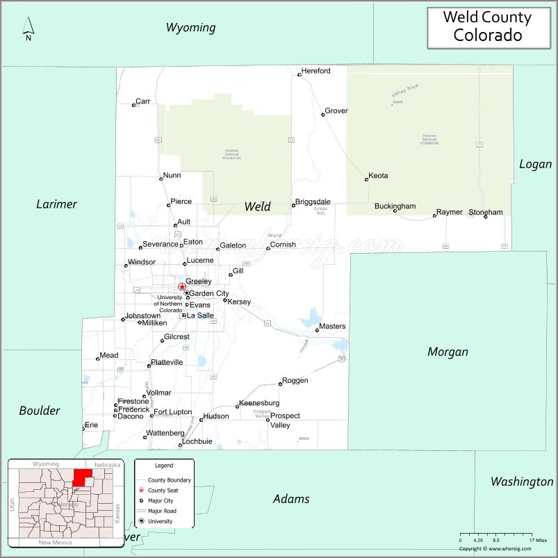
About Weld County Map, Colorado: The map showing the county boundary, county seat, major cities, highways, water bodies and neighbouring counties.
Most Viewed Links
Map of Weld County, Colorado
Weld County is a county located in the U.S. state of Colorado. It's county seat is Greeley. As per 2020 census, the population of Weld County is 340036 people and population density is square miles. According to the United States Census Bureau, the county has a total area of 4,013.84 sq mi (10,396 km2). Weld County was established on -13938.
Weld County Facts
| Continent | North America |
| Country | United States |
| State | Colorado |
| County Seat | Greeley |
| Largest City/Town | Greeley |
| Established | 1861 |
| Total Area | 4,017 sq mi (10,404 sq km) |
| Land Area | 3,987 sq mi (10,326 sq km) |
| Water Area | 30 sq mi (78 sq km) |
| Population | 328,981 (Census 2020) |
| Population Density | 82.5 people per sq mi |
| Time Zone | Mountain Time Zone (MST/MDT) |
| Major Highways | Interstate 25, US Highway 34, US Highway 85, State Highway 14 |
| Major Rivers | South Platte River, Cache la Poudre River |
| Neighboring Counties | Larimer County, Boulder County, Adams County, Morgan County, Logan County, Laramie County (WY) |
| Famous For | Agriculture, energy production, Greeley, cattle ranching, and northern Colorado industry |
| Top Attractions | Pawnee National Grassland, Centennial Village Museum, University of Northern Colorado, South Platte recreation |
| Official Website | Official Website |
About Weld County, Colorado
Weld County is located in northern Colorado in the United States and was established in 1861 as one of the original counties of the Colorado Territory. The county seat and largest city is Greeley. Weld County is known for agriculture, cattle ranching, oil and gas production, higher education, and rapidly growing communities along Colorado’s Front Range.
Cities and Towns in Weld County, Colorado
| City/Town | Population (Census 2020) | Latitude & Longitude |
|---|---|---|
| Greeley (county seat) | 108,795 | 40.4233°N, 104.7091°W |
| Evans | 21,374 | 40.3764°N, 104.6922°W |
| Windsor (partly) | 32,716 | 40.4775°N, 104.9014°W |
| Firestone | 16,381 | 40.1200°N, 104.9369°W |
| Dacono | 6,297 | 40.0847°N, 104.9394°W |
| Frederick | 14,975 | 40.1000°N, 104.9375°W |
| Fort Lupton | 8,955 | 40.0847°N, 104.8136°W |
| Severance | 7,684 | 40.5247°N, 104.8514°W |
| Johnstown (partly) | 17,377 | 40.3369°N, 104.9125°W |
| Kersey | 1,495 | 40.3875°N, 104.5617°W |
| La Salle | 2,359 | 40.3481°N, 104.7003°W |
| Platteville | 2,654 | 40.2144°N, 104.8228°W |
Golf Courses in Weld County, Colorado
| Golf Course | Location | Latitude & Longitude |
|---|---|---|
| Boomerang Links | Greeley | 40.4103°N, 104.7447°W |
| Highland Hills Golf Course | Greeley | 40.4417°N, 104.7247°W |
| Pelican Lakes Golf Club | Windsor | 40.4581°N, 104.9214°W |
| Mad Russian Golf Club | Milliken | 40.3289°N, 104.8503°W |
Roads and Highways in Weld County, Colorado
Major highways connect the county to Denver, Wyoming, and northern Colorado communities.
- Interstate 25 - major north-south interstate connecting Weld County with Denver, Fort Collins, and Wyoming
- US Highway 34 - east-west route linking Greeley with Loveland and eastern Colorado
- US Highway 85 - regional highway serving northern Front Range communities
- Colorado State Highway 14 - route connecting Greeley with Sterling and northeastern Colorado
Neighboring Counties of Weld County
- Larimer County (west)
- Boulder County (southwest)
- Adams County (south)
- Morgan County (southeast)
- Logan County (east)
- Laramie County, Wyoming (north)
Top Attractions in Weld County, Colorado
The county offers a mix of cultural attractions, outdoor recreation, and agricultural heritage destinations.
- Pawnee National Grassland - prairie recreation area known for hiking, camping, and birdwatching
- University of Northern Colorado - major educational institution with cultural and sports events
- Centennial Village Museum - historic village museum featuring pioneer-era buildings and exhibits
- South Platte River recreation areas - fishing, boating, and wildlife viewing opportunities
- Island Grove Regional Park - fairgrounds, rodeos, festivals, and community events
- Greeley History Museum - exhibits on local history, agriculture, and settlement
- Poudre River Trail recreation areas - biking and walking trails connecting northern Colorado communities
- WeldWerks Brewing Co. and downtown Greeley attractions - local dining and entertainment district
- Rocky Mountain National Park access routes nearby - scenic drives and recreation connections
- High Plains and agricultural scenic drives - ranchland and farming landscapes
- Annual Greeley Stampede - major rodeo and western heritage festival
- Platte River Fort historical site - reconstructed fur trading fort and historical exhibits
Distance from Weld County to Nearby Cities
The following distances are measured by road (driving).
- Greeley to Fort Collins (Larimer County), Colorado - 31 mi (50 km)
- Greeley to Denver (Denver County), Colorado - 63 mi (101 km)
- Greeley to Boulder (Boulder County), Colorado - 47 mi (76 km)
- Greeley to Cheyenne (Laramie County), Wyoming - 57 mi (92 km)
- Greeley to Sterling (Logan County), Colorado - 78 mi (126 km)
- Greeley to Colorado Springs (El Paso County), Colorado - 132 mi (212 km)
- Greeley to Grand Junction (Mesa County), Colorado - 279 mi (449 km)
- Greeley to Rapid City (Pennington County), South Dakota - 331 mi (533 km)
- Greeley to Omaha (Douglas County), Nebraska - 490 mi (788 km)
- Greeley to Salt Lake City (Salt Lake County), Utah - 493 mi (793 km)
- Greeley to Albuquerque (Bernalillo County), New Mexico - 455 mi (732 km)
- Greeley to Wichita (Sedgwick County), Kansas - 447 mi (719 km)
FAQs about Weld County
Weld County is located in northern Colorado along the Front Range region of the United States.
The population of Weld County was 328,981 according to the Census 2020.
Weld County is known for agriculture, cattle ranching, oil and gas production, and the city of Greeley.
The county is served by Interstate 25, US Highway 34, US Highway 85, and Colorado State Highway 14.
Popular attractions include Pawnee National Grassland, the University of Northern Colorado, Centennial Village Museum, and the Greeley Stampede.
References
- QuickFacts - U.S. Census Bureau
- United States Census Bureau
- United States Geological Survey (USGS)
- National Geodetic Survey
- Official Website
- Adams County Map
- Alamosa County Map
- Arapahoe County Map
- Archuleta County Map
- Baca County Map
- Bent County Map
- Boulder County Map
- Broomfield County Map
- Chaffee County Map
- Cheyenne County Map
- Clear Creek County Map
- Conejos County Map
- Costilla County Map
- Crowley County Map
- Custer County Map
- Delta County Map
- Denver County Map
- Dolores County Map
- Douglas County Map
- Eagle County Map
- Elbert County Map
- El Paso County Map
- Fremont County Map
- Garfield County Map
- Gilpin County Map
- Grand County Map
- Gunnison County Map
- Hinsdale County Map
- Huerfano County Map
- Jackson County Map
- Jefferson County Map
- Kiowa County Map
- Kit Carson County Map
- Lake County Map
- La Plata County Map
- Larimer County Map
- Las Animas County Map
- Lincoln County Map
- Logan County Map
- Mesa County Map
- Mineral County Map
- Moffat County Map
- Montezuma County Map
- Montrose County Map
- Morgan County Map
- Otero County Map
- Ouray County Map
- Park County Map
- Phillips County Map
- Pitkin County Map
- Prowers County Map
- Pueblo County Map
- Rio Blanco County Map
- Rio Grande County Map
- Routt County Map
- Saguache County Map
- San Juan County Map
- San Miguel County Map
- Sedgwick County Map
- Summit County Map
- Teller County Map
- Washington County Map
- Weld County Map
- Yuma County Map
- Alabama Counties
- Alaska boroughs
- Arizona Counties
- Arkansas Counties
- California County Map
- Colorado Counties
- Connecticut Counties
- Delaware Counties
- Florida County Map
- Georgia County Map
- Hawaii Counties
- Idaho Counties
- Illinois Counties
- Indiana Counties
- Iowa Counties
- Kansas Counties
- Kentucky Counties
- Louisiana Counties
- Maine Counties
- Maryland Counties
- Massachusetts Counties
- Michigan County Map
- Minnesota Counties
- Mississippi Counties
- Missouri Counties
- Montana Counties
- Nebraska Counties
- Nevada Counties
- New York Counties
- New Hampshire Counties
- New Jersey Counties
- New Mexico Counties
- North Carolina Counties
- North Dakota Counties
- Ohio County Map
- Oklahoma Counties
- Oregon Counties
- Pennsylvania Counties
- Rhode Island Counties
- South Carolina Counties
- South Dakota Counties
- Map of Tennessee
- Texas County Map
- Utah Counties
- Vermont Counties
- Virginia Counties
- Washington Counties
- West Virginia Counties
- Wisconsin Counties
- Wyoming Counties