Map of Clear Creek County - Clear Creek County is a county located in the U.S. state of Colorado. Clear Creek County Map showing cities, highways, important places and water bodies. Get Where is Clear Creek County located in the map, major cities in Clear Creek county, population, areas, and places of interest.
Map of Clear Creek County, Colorado
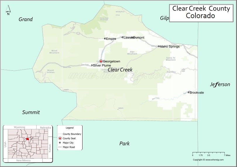
About Clear Creek County Map, Colorado: The map showing the county boundary, county seat, major cities, highways, water bodies and neighbouring counties.
Most Viewed Links
Map of Clear Creek County, Colorado
Clear Creek County is a county located in the U.S. state of Colorado. It's county seat is Georgetown. As per 2020 census, the population of Clear Creek County is 9446 people and population density is square miles. According to the United States Census Bureau, the county has a total area of 396.53 sq mi (1,027 km2). Clear Creek County was established on -13938.
Clear Creek County Facts
| Continent | North America |
| Country | United States |
| State | Colorado |
| County Seat | Georgetown |
| Largest City/Town | Idaho Springs |
| Established | 1861 |
| Total Area | 396 sq mi (1,026 sq km) |
| Land Area | 395 sq mi (1,023 sq km) |
| Water Area | 1 sq mi (3 sq km) |
| Population | 9,397 (Census 2020) |
| Population Density | 23.8 people per sq mi |
| Time Zone | Mountain Time Zone (MST/MDT) |
| Major Highways | Interstate 70, US Highway 6, State Highway 103 |
| Major Rivers | Clear Creek |
| Neighboring Counties | Grand County, Gilpin County, Jefferson County, Summit County, Park County |
| Famous For | Historic mining towns, mountain scenery, skiing, hot springs, and Interstate 70 mountain corridor |
| Top Attractions | Georgetown Loop Railroad, Mount Blue Sky Scenic Byway, Loveland Ski Area, St. Mary's Glacier |
| Official Website | Official Website |
About Clear Creek County, Colorado
Clear Creek County is located in central Colorado in the United States and was established in 1861 as one of the original counties of the Colorado Territory. The county seat is Georgetown, while Idaho Springs is the largest town. The county is known for its Rocky Mountain scenery, historic mining communities, mountain recreation, and scenic transportation routes through the Continental Divide region.
Cities and Towns in Clear Creek County, Colorado
| City/Town | Population (Census 2020) | Latitude & Longitude |
|---|---|---|
| Georgetown (county seat) | 1,118 | 39.7061°N, 105.6975°W |
| Idaho Springs | 1,782 | 39.7425°N, 105.5136°W |
| Empire | 304 | 39.7611°N, 105.6825°W |
| Silver Plume | 200 | 39.6950°N, 105.7272°W |
| Dumont (CDP) | 702 | 39.7644°N, 105.6000°W |
| Downieville-Lawson-Dumont (CDP) | 1,015 | 39.7647°N, 105.6053°W |
| Floyd Hill (CDP) | 270 | 39.7189°N, 105.4478°W |
| St. Mary's (CDP) | 339 | 39.8208°N, 105.6453°W |
| Upper Bear Creek (CDP) | 26 | 39.6822°N, 105.4147°W |
Golf Courses in Clear Creek County, Colorado
| Golf Course | Location | Latitude & Longitude |
|---|---|---|
| Hiwan Golf Club | Evergreen | 39.6483°N, 105.3294°W |
| Mount Evans Golf Course | Idaho Springs | 39.7478°N, 105.5308°W |
| Evergreen Golf Course | Evergreen | 39.6289°N, 105.3172°W |
Roads and Highways in Clear Creek County, Colorado
Major highways connect the county to Denver, mountain passes, and ski resort regions.
- Interstate 70 - major east-west interstate connecting Idaho Springs, Georgetown, and mountain resort areas
- US Highway 6 - scenic highway running parallel to Interstate 70 through mountain communities
- Colorado State Highway 103 - scenic route connecting Idaho Springs with Mount Blue Sky and Echo Lake
Neighboring Counties of Clear Creek County
- Grand County (north)
- Gilpin County (east)
- Jefferson County (southeast)
- Park County (south)
- Summit County (west)
Top Attractions in Clear Creek County, Colorado
The county offers a mix of natural and cultural attractions.
- Georgetown Loop Railroad - historic narrow-gauge railroad offering scenic mountain rides
- Mount Blue Sky Scenic Byway - high-altitude scenic drive with alpine views and wildlife
- Loveland Ski Area - major ski destination near the Continental Divide
- St. Mary's Glacier - popular hiking destination featuring alpine scenery and a small glacier
- Indian Hot Springs - historic geothermal hot springs resort in Idaho Springs
- Georgetown Historic District - preserved Victorian-era mining town with museums and shops
- Echo Lake Park - scenic mountain lake area near Mount Blue Sky
- Phoenix Gold Mine - historic mine tours showcasing Colorado mining history
- Clear Creek Rafting Areas - whitewater rafting and kayaking sections along Clear Creek
- Silver Plume Historic District - small mining town with preserved historic buildings
- Herman Gulch Trail - scenic hiking trail known for alpine meadows and mountain views
- Argo Gold Mill and Tunnel - historic mining attraction and tour site in Idaho Springs
Distance from Clear Creek County to Nearby Cities
The following distances are measured by road (driving).
- Georgetown to Denver (Denver County), Colorado - 46 mi (74 km)
- Georgetown to Idaho Springs (Clear Creek County), Colorado - 12 mi (19 km)
- Georgetown to Breckenridge (Summit County), Colorado - 43 mi (69 km)
- Georgetown to Golden (Jefferson County), Colorado - 32 mi (51 km)
- Georgetown to Boulder (Boulder County), Colorado - 53 mi (85 km)
- Georgetown to Colorado Springs (El Paso County), Colorado - 116 mi (187 km)
- Georgetown to Frisco (Summit County), Colorado - 33 mi (53 km)
- Georgetown to Leadville (Lake County), Colorado - 63 mi (101 km)
- Georgetown to Aspen (Pitkin County), Colorado - 138 mi (222 km)
- Georgetown to Winter Park (Grand County), Colorado - 51 mi (82 km)
- Georgetown to Vail (Eagle County), Colorado - 72 mi (116 km)
- Georgetown to Estes Park (Larimer County), Colorado - 87 mi (140 km)
FAQs about Clear Creek County
Clear Creek County is located in central Colorado within the Rocky Mountains west of Denver in the United States.
The population of Clear Creek County was 9,397 according to the Census 2020.
Clear Creek County is known for historic mining towns, mountain recreation, scenic byways, skiing, and hot springs.
The county is served by Interstate 70, US Highway 6, and Colorado State Highway 103.
Yes, Clear Creek County has golf facilities including Mount Evans Golf Course and nearby mountain golf clubs.
References
- QuickFacts - U.S. Census Bureau
- United States Census Bureau
- United States Geological Survey (USGS)
- National Geodetic Survey
- Official Website
- Adams County Map
- Alamosa County Map
- Arapahoe County Map
- Archuleta County Map
- Baca County Map
- Bent County Map
- Boulder County Map
- Broomfield County Map
- Chaffee County Map
- Cheyenne County Map
- Clear Creek County Map
- Conejos County Map
- Costilla County Map
- Crowley County Map
- Custer County Map
- Delta County Map
- Denver County Map
- Dolores County Map
- Douglas County Map
- Eagle County Map
- Elbert County Map
- El Paso County Map
- Fremont County Map
- Garfield County Map
- Gilpin County Map
- Grand County Map
- Gunnison County Map
- Hinsdale County Map
- Huerfano County Map
- Jackson County Map
- Jefferson County Map
- Kiowa County Map
- Kit Carson County Map
- Lake County Map
- La Plata County Map
- Larimer County Map
- Las Animas County Map
- Lincoln County Map
- Logan County Map
- Mesa County Map
- Mineral County Map
- Moffat County Map
- Montezuma County Map
- Montrose County Map
- Morgan County Map
- Otero County Map
- Ouray County Map
- Park County Map
- Phillips County Map
- Pitkin County Map
- Prowers County Map
- Pueblo County Map
- Rio Blanco County Map
- Rio Grande County Map
- Routt County Map
- Saguache County Map
- San Juan County Map
- San Miguel County Map
- Sedgwick County Map
- Summit County Map
- Teller County Map
- Washington County Map
- Weld County Map
- Yuma County Map
- Alabama Counties
- Alaska boroughs
- Arizona Counties
- Arkansas Counties
- California County Map
- Colorado Counties
- Connecticut Counties
- Delaware Counties
- Florida County Map
- Georgia County Map
- Hawaii Counties
- Idaho Counties
- Illinois Counties
- Indiana Counties
- Iowa Counties
- Kansas Counties
- Kentucky Counties
- Louisiana Counties
- Maine Counties
- Maryland Counties
- Massachusetts Counties
- Michigan County Map
- Minnesota Counties
- Mississippi Counties
- Missouri Counties
- Montana Counties
- Nebraska Counties
- Nevada Counties
- New York Counties
- New Hampshire Counties
- New Jersey Counties
- New Mexico Counties
- North Carolina Counties
- North Dakota Counties
- Ohio County Map
- Oklahoma Counties
- Oregon Counties
- Pennsylvania Counties
- Rhode Island Counties
- South Carolina Counties
- South Dakota Counties
- Map of Tennessee
- Texas County Map
- Utah Counties
- Vermont Counties
- Virginia Counties
- Washington Counties
- West Virginia Counties
- Wisconsin Counties
- Wyoming Counties