Map of Saguache County - Saguache County is a county located in the U.S. state of Colorado. Saguache County Map showing cities, highways, important places and water bodies. Get Where is Saguache County located in the map, major cities in Saguache county, population, areas, and places of interest.
Map of Saguache County, Colorado
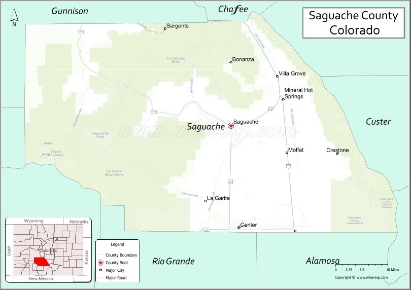
About Saguache County Map, Colorado: The map showing the county boundary, county seat, major cities, highways, water bodies and neighbouring counties.
Most Viewed Links
Map of Saguache County, Colorado
Saguache County is a county located in the U.S. state of Colorado. It's county seat is Saguache. As per 2020 census, the population of Saguache County is 6471 people and population density is square miles. According to the United States Census Bureau, the county has a total area of 3,168.32 sq mi (8,206 km2). Saguache County was established on -12054.
Saguache County Facts
| Continent | North America |
| Country | United States |
| State | Colorado |
| County Seat | Saguache |
| Largest City/Town | Crestone |
| Established | 1866 |
| Total Area | 3,170 sq mi (8,210 sq km) |
| Land Area | 3,149 sq mi (8,156 sq km) |
| Water Area | 21 sq mi (54 sq km) |
| Population | 6,368 (Census 2020) |
| Population Density | 2.0 people per sq mi |
| Time Zone | Mountain Time Zone (MST/MDT) |
| Major Highways | US Highway 285, US Highway 50, State Highway 17 |
| Major Rivers | Rio Grande, Saguache Creek |
| Neighboring Counties | Chaffee County, Gunnison County, Hinsdale County, Rio Grande County, Alamosa County, Custer County |
| Famous For | San Luis Valley, Great Sand Dunes nearby, spiritual retreats, and mountain wilderness |
| Top Attractions | Great Sand Dunes nearby, Crestone spiritual centers, San Luis Lakes, Sangre de Cristo Mountains |
| Official Website | Official Website |
About Saguache County, Colorado
Saguache County is located in south-central Colorado in the United States and was established in 1866. The county seat is Saguache, while Crestone is one of the best-known communities in the county. The county is known for vast mountain landscapes, spiritual retreat centers, wildlife areas, agricultural valleys, and recreation opportunities within the San Luis Valley and Sangre de Cristo Mountains.
Cities and Communities in Saguache County, Colorado
| City/Town | Population (Census 2020) | Latitude & Longitude |
|---|---|---|
| Saguache (county seat) | 485 | 38.0875°N, 106.1411°W |
| Crestone | 141 | 37.9961°N, 105.6994°W |
| Moffat | 108 | 37.9972°N, 105.9061°W |
| Center (partly) | 2,105 | 37.7539°N, 106.1086°W |
| Villa Grove | Rural community | 38.2481°N, 105.9492°W |
| Bonanza | Historic mining town | 38.1986°N, 106.1492°W |
| San Luis Valley region | Agricultural landscape area | 38.0000°N, 106.0000°W |
| Sangre de Cristo foothills | Mountain recreation region | 38.0200°N, 105.7000°W |
Golf Courses in Saguache County, Colorado
| Golf Course | Location | Latitude & Longitude |
|---|---|---|
| Monte Vista Golf Club | Monte Vista nearby | 37.5792°N, 106.1483°W |
| Cattails Golf Course | Alamosa nearby | 37.4725°N, 105.8731°W |
| Salida Golf Club | Salida nearby | 38.5344°N, 105.9953°W |
Roads and Highways in Saguache County, Colorado
Major highways connect the county to the San Luis Valley, mountain passes, and central Colorado communities.
- US Highway 285 - major north-south route connecting the San Luis Valley with Denver and New Mexico
- US Highway 50 - east-west highway crossing northern portions of the county
- Colorado State Highway 17 - scenic route serving the San Luis Valley and Great Sand Dunes region
Neighboring Counties of Saguache County
- Chaffee County (north)
- Gunnison County (northwest)
- Hinsdale County (west)
- Rio Grande County (southwest)
- Alamosa County (south)
- Custer County (east)
Top Attractions in Saguache County, Colorado
The county offers a mix of mountain recreation, spiritual tourism, and scenic natural attractions.
- Great Sand Dunes National Park and Preserve nearby - towering sand dunes and outdoor recreation destination
- Crestone spiritual centers - meditation retreats, temples, and religious communities from multiple traditions
- Sangre de Cristo Mountains - hiking, camping, and mountain recreation opportunities
- San Luis Lakes State Wildlife Area - birdwatching and wildlife viewing destination
- Rio Grande National Forest recreation areas - fishing, hiking, and camping opportunities
- North Crestone Creek Trail - scenic hiking route into alpine mountain terrain
- Penitente Canyon nearby - rock climbing and outdoor recreation area
- Bonanza historic mining district - remnants of Colorado mining history
- Baca Grande community - unique mountain and valley residential area near Crestone
- San Luis Valley scenic drives - open valley landscapes and mountain panoramas
- Villa Grove hot springs region nearby - natural geothermal attractions
- Dark sky viewing and stargazing areas - remote landscapes with limited light pollution
Distance from Saguache County to Nearby Cities
The following distances are measured by road (driving).
- Saguache to Salida (Chaffee County), Colorado - 52 mi (84 km)
- Saguache to Alamosa (Alamosa County), Colorado - 52 mi (84 km)
- Saguache to Gunnison (Gunnison County), Colorado - 64 mi (103 km)
- Saguache to Monte Vista (Rio Grande County), Colorado - 52 mi (84 km)
- Saguache to Colorado Springs (El Paso County), Colorado - 140 mi (225 km)
- Saguache to Pueblo (Pueblo County), Colorado - 118 mi (190 km)
- Saguache to Denver (Denver County), Colorado - 190 mi (306 km)
- Saguache to Durango (La Plata County), Colorado - 171 mi (275 km)
- Saguache to Grand Junction (Mesa County), Colorado - 206 mi (332 km)
- Saguache to Santa Fe (Santa Fe County), New Mexico - 210 mi (338 km)
- Saguache to Albuquerque (Bernalillo County), New Mexico - 267 mi (430 km)
- Saguache to Aspen (Pitkin County), Colorado - 135 mi (217 km)
FAQs about Saguache County
Saguache County is located in south-central Colorado within the San Luis Valley region of the United States.
The population of Saguache County was 6,368 according to the Census 2020.
Saguache County is known for mountain scenery, spiritual retreat centers, San Luis Valley landscapes, and outdoor recreation.
The county is served by US Highway 285, US Highway 50, and Colorado State Highway 17.
Popular attractions include Great Sand Dunes nearby, Crestone spiritual centers, Sangre de Cristo mountain recreation, and San Luis Lakes wildlife areas.
References
- QuickFacts - U.S. Census Bureau
- United States Census Bureau
- United States Geological Survey (USGS)
- National Geodetic Survey
- Official Website
- Adams County Map
- Alamosa County Map
- Arapahoe County Map
- Archuleta County Map
- Baca County Map
- Bent County Map
- Boulder County Map
- Broomfield County Map
- Chaffee County Map
- Cheyenne County Map
- Clear Creek County Map
- Conejos County Map
- Costilla County Map
- Crowley County Map
- Custer County Map
- Delta County Map
- Denver County Map
- Dolores County Map
- Douglas County Map
- Eagle County Map
- Elbert County Map
- El Paso County Map
- Fremont County Map
- Garfield County Map
- Gilpin County Map
- Grand County Map
- Gunnison County Map
- Hinsdale County Map
- Huerfano County Map
- Jackson County Map
- Jefferson County Map
- Kiowa County Map
- Kit Carson County Map
- Lake County Map
- La Plata County Map
- Larimer County Map
- Las Animas County Map
- Lincoln County Map
- Logan County Map
- Mesa County Map
- Mineral County Map
- Moffat County Map
- Montezuma County Map
- Montrose County Map
- Morgan County Map
- Otero County Map
- Ouray County Map
- Park County Map
- Phillips County Map
- Pitkin County Map
- Prowers County Map
- Pueblo County Map
- Rio Blanco County Map
- Rio Grande County Map
- Routt County Map
- Saguache County Map
- San Juan County Map
- San Miguel County Map
- Sedgwick County Map
- Summit County Map
- Teller County Map
- Washington County Map
- Weld County Map
- Yuma County Map
- Alabama Counties
- Alaska boroughs
- Arizona Counties
- Arkansas Counties
- California County Map
- Colorado Counties
- Connecticut Counties
- Delaware Counties
- Florida County Map
- Georgia County Map
- Hawaii Counties
- Idaho Counties
- Illinois Counties
- Indiana Counties
- Iowa Counties
- Kansas Counties
- Kentucky Counties
- Louisiana Counties
- Maine Counties
- Maryland Counties
- Massachusetts Counties
- Michigan County Map
- Minnesota Counties
- Mississippi Counties
- Missouri Counties
- Montana Counties
- Nebraska Counties
- Nevada Counties
- New York Counties
- New Hampshire Counties
- New Jersey Counties
- New Mexico Counties
- North Carolina Counties
- North Dakota Counties
- Ohio County Map
- Oklahoma Counties
- Oregon Counties
- Pennsylvania Counties
- Rhode Island Counties
- South Carolina Counties
- South Dakota Counties
- Map of Tennessee
- Texas County Map
- Utah Counties
- Vermont Counties
- Virginia Counties
- Washington Counties
- West Virginia Counties
- Wisconsin Counties
- Wyoming Counties