Map of Bent County - Bent County is a county located in the U.S. state of Colorado. Bent County Map showing cities, highways, important places and water bodies. Get Where is Bent County located in the map, major cities in Bent county, population, areas, and places of interest.
Map of Bent County, Colorado
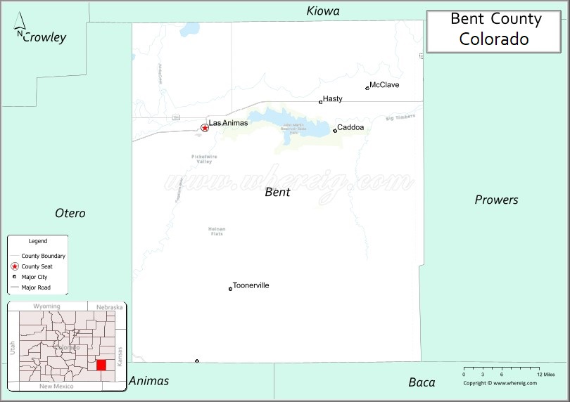
About Bent County Map, Colorado: The map showing the county boundary, county seat, major cities, highways, water bodies and neighbouring counties.
Most Viewed Links
Map of Bent County, Colorado
Bent County is a county located in the U.S. state of Colorado. It's county seat is Las Animas. As per 2020 census, the population of Bent County is 5759 people and population density is square miles. According to the United States Census Bureau, the county has a total area of 1,541.07 sq mi (3,991 km2). Bent County was established on -10914.
Bent County Facts
| Continent | North America |
| Country | United States |
| State | Colorado |
| County Seat | Las Animas |
| Largest City/Town | Las Animas |
| Established | 1870 |
| Total Area | 1,541 sq mi (3,991 sq km) |
| Land Area | 1,513 sq mi (3,919 sq km) |
| Water Area | 28 sq mi (73 sq km) |
| Population | 5,650 (Census 2020) |
| Population Density | 3.7 people per sq mi |
| Time Zone | Mountain Time Zone (MST/MDT) |
| Major Highways | US Highway 50, State Highway 101, State Highway 194 |
| Major Rivers | Arkansas River, Purgatoire River |
| Neighboring Counties | Otero County, Kiowa County, Prowers County, Las Animas County |
| Famous For | Bent's Old Fort, Arkansas River Valley, farming, ranching, and historic Santa Fe Trail sites |
| Top Attractions | Bent's Old Fort National Historic Site, John Martin Reservoir State Park, Santa Fe Trail landmarks, Arkansas River recreation |
| Official Website | Official Website |
About Bent County, Colorado
Bent County is located in southeastern Colorado in the United States and was established in 1870. The county seat and largest town is Las Animas. The county is known for its historic role along the Santa Fe Trail, fertile river valleys, agricultural communities, and important western heritage landmarks.
Cities and Towns in Bent County, Colorado
| City/Town | Population (Census 2020) | Latitude & Longitude |
|---|---|---|
| Las Animas (county seat) | 2,410 | 38.0667°N, 103.2227°W |
| Hasty | 182 | 38.1083°N, 102.9569°W |
| McClave | 618 | 38.1442°N, 102.8708°W |
| Fort Lyon (CDP) | 230 | 38.0878°N, 103.1453°W |
| Las Animas Junction (CDP) | 21 | 38.0875°N, 103.1744°W |
Golf Courses in Bent County, Colorado
| Golf Course | Location | Latitude & Longitude |
|---|---|---|
| Las Animas Golf Course | Las Animas | 38.0589°N, 103.2261°W |
| John Martin Reservoir Disc Golf Area | Hasty | 38.0736°N, 102.9378°W |
Roads and Highways in Bent County, Colorado
Major highways connect the county to southeastern Colorado communities and nearby agricultural regions.
- US Highway 50 - major east-west highway connecting Las Animas with La Junta and Lamar
- Colorado State Highway 101 - north-south route connecting Las Animas with Toonerville and rural areas
- Colorado State Highway 194 - regional route connecting the county with Kim and southern plains areas
Neighboring Counties of Bent County
- Kiowa County (north)
- Prowers County (east)
- Las Animas County (south)
- Otero County (west)
Top Attractions in Bent County, Colorado
The county offers a mix of natural and historical attractions.
- Bent's Old Fort National Historic Site - reconstructed 1840s adobe trading post along the Santa Fe Trail
- John Martin Reservoir State Park - popular recreation area for boating, fishing, camping, and birdwatching
- Santa Fe Trail Historic Sites - historic trail landmarks tied to western expansion and trade
- Arkansas River Recreation Areas - scenic spots for fishing, kayaking, and wildlife viewing
- Fort Lyon Historic District - historic military fort and former veterans facility
- Las Animas City Park - local public park with picnic and recreation facilities
- Comanche National Grassland Access Areas - nearby prairie landscapes and wildlife habitats
- John Martin Wildlife Area - habitat area known for migratory birds and outdoor recreation
- Bent County Museum - local history exhibits featuring ranching and pioneer heritage
- McClave Community Park - small-town recreation area with sports and picnic facilities
Distance from Bent County to Nearby Cities
The following distances are measured by road (driving).
- Las Animas to La Junta (Otero County), Colorado - 13 mi (21 km)
- Las Animas to Lamar (Prowers County), Colorado - 71 mi (114 km)
- Las Animas to Pueblo (Pueblo County), Colorado - 87 mi (140 km)
- Las Animas to Colorado Springs (El Paso County), Colorado - 127 mi (204 km)
- Las Animas to Trinidad (Las Animas County), Colorado - 104 mi (167 km)
- Las Animas to Denver (Denver County), Colorado - 209 mi (336 km)
- Las Animas to Dodge City (Ford County), Kansas - 168 mi (270 km)
- Las Animas to Garden City (Finney County), Kansas - 191 mi (307 km)
- Las Animas to Springfield (Baca County), Colorado - 135 mi (217 km)
- Las Animas to Rocky Ford (Otero County), Colorado - 27 mi (43 km)
- Las Animas to Canon City (Fremont County), Colorado - 104 mi (167 km)
- Las Animas to Walsenburg (Huerfano County), Colorado - 78 mi (126 km)
FAQs about Bent County
Bent County is located in southeastern Colorado along the Arkansas River Valley in the United States.
The population of Bent County was 5,650 according to the Census 2020.
Bent County is known for Bent's Old Fort, Santa Fe Trail history, farming, ranching, and outdoor recreation around John Martin Reservoir.
The county is mainly served by US Highway 50, Colorado State Highway 101, and Colorado State Highway 194.
Yes, Bent County has golf facilities including Las Animas Golf Course near Las Animas.
References
- QuickFacts - U.S. Census Bureau
- United States Census Bureau
- United States Geological Survey (USGS)
- National Geodetic Survey
- Official County Website
- Adams County Map
- Alamosa County Map
- Arapahoe County Map
- Archuleta County Map
- Baca County Map
- Bent County Map
- Boulder County Map
- Broomfield County Map
- Chaffee County Map
- Cheyenne County Map
- Clear Creek County Map
- Conejos County Map
- Costilla County Map
- Crowley County Map
- Custer County Map
- Delta County Map
- Denver County Map
- Dolores County Map
- Douglas County Map
- Eagle County Map
- Elbert County Map
- El Paso County Map
- Fremont County Map
- Garfield County Map
- Gilpin County Map
- Grand County Map
- Gunnison County Map
- Hinsdale County Map
- Huerfano County Map
- Jackson County Map
- Jefferson County Map
- Kiowa County Map
- Kit Carson County Map
- Lake County Map
- La Plata County Map
- Larimer County Map
- Las Animas County Map
- Lincoln County Map
- Logan County Map
- Mesa County Map
- Mineral County Map
- Moffat County Map
- Montezuma County Map
- Montrose County Map
- Morgan County Map
- Otero County Map
- Ouray County Map
- Park County Map
- Phillips County Map
- Pitkin County Map
- Prowers County Map
- Pueblo County Map
- Rio Blanco County Map
- Rio Grande County Map
- Routt County Map
- Saguache County Map
- San Juan County Map
- San Miguel County Map
- Sedgwick County Map
- Summit County Map
- Teller County Map
- Washington County Map
- Weld County Map
- Yuma County Map
- Alabama Counties
- Alaska boroughs
- Arizona Counties
- Arkansas Counties
- California County Map
- Colorado Counties
- Connecticut Counties
- Delaware Counties
- Florida County Map
- Georgia County Map
- Hawaii Counties
- Idaho Counties
- Illinois Counties
- Indiana Counties
- Iowa Counties
- Kansas Counties
- Kentucky Counties
- Louisiana Counties
- Maine Counties
- Maryland Counties
- Massachusetts Counties
- Michigan County Map
- Minnesota Counties
- Mississippi Counties
- Missouri Counties
- Montana Counties
- Nebraska Counties
- Nevada Counties
- New York Counties
- New Hampshire Counties
- New Jersey Counties
- New Mexico Counties
- North Carolina Counties
- North Dakota Counties
- Ohio County Map
- Oklahoma Counties
- Oregon Counties
- Pennsylvania Counties
- Rhode Island Counties
- South Carolina Counties
- South Dakota Counties
- Map of Tennessee
- Texas County Map
- Utah Counties
- Vermont Counties
- Virginia Counties
- Washington Counties
- West Virginia Counties
- Wisconsin Counties
- Wyoming Counties