Map of Summit County - Summit County is a county located in the U.S. state of Colorado. Summit County Map showing cities, highways, important places and water bodies. Get Where is Summit County located in the map, major cities in Summit county, population, areas, and places of interest.
Map of Summit County, Colorado
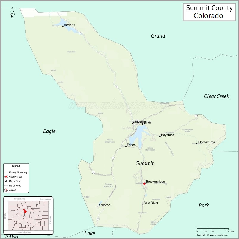
About Summit County Map, Colorado: The map showing the county boundary, county seat, major cities, highways, water bodies and neighbouring counties.
Most Viewed Links
Map of Summit County, Colorado
Summit County is a county located in the U.S. state of Colorado. It's county seat is Breckenridge. As per 2020 census, the population of Summit County is 30941 people and population density is square miles. According to the United States Census Bureau, the county has a total area of 618.92 sq mi (1,603 km2). Summit County was established on -13938.
Summit County Facts
| Continent | North America |
| Country | United States |
| State | Colorado |
| County Seat | Breckenridge |
| Largest City/Town | Breckenridge |
| Established | 1861 |
| Total Area | 619 sq mi (1,603 sq km) |
| Land Area | 608 sq mi (1,575 sq km) |
| Water Area | 11 sq mi (28 sq km) |
| Population | 31,055 (Census 2020) |
| Population Density | 51.1 people per sq mi |
| Time Zone | Mountain Time Zone (MST/MDT) |
| Major Highways | Interstate 70, US Highway 6, State Highway 9 |
| Major Rivers | Blue River, Snake River, Tenmile Creek |
| Neighboring Counties | Grand County, Clear Creek County, Park County, Lake County, Eagle County |
| Famous For | Ski resorts, Rocky Mountain scenery, outdoor recreation, and Breckenridge tourism |
| Top Attractions | Breckenridge Ski Resort, Keystone Resort, Dillon Reservoir, Copper Mountain |
| Official Website | Official Website |
About Summit County, Colorado
Summit County is located in central Colorado in the United States and was established in 1861 as one of the original counties of the Colorado Territory. The county seat and largest town is Breckenridge. The county is known for world-famous ski resorts, alpine recreation, mountain scenery, and year-round tourism in the Rocky Mountains.
Cities and Towns in Summit County, Colorado
| City/Town | Population (Census 2020) | Latitude & Longitude |
|---|---|---|
| Breckenridge (county seat) | 5,078 | 39.4817°N, 106.0384°W |
| Dillon | 1,064 | 39.6272°N, 106.0434°W |
| Frisco | 2,913 | 39.5744°N, 106.0975°W |
| Silverthorne | 4,402 | 39.6325°N, 106.0747°W |
| Blue River | 892 | 39.4347°N, 106.0436°W |
| Montezuma | 65 | 39.5825°N, 105.8550°W |
| Keystone area | Ski resort region | 39.6061°N, 105.9439°W |
| Copper Mountain area | Mountain recreation region | 39.5022°N, 106.1519°W |
Golf Courses in Summit County, Colorado
| Golf Course | Location | Latitude & Longitude |
|---|---|---|
| Breckenridge Golf Club | Breckenridge | 39.5200°N, 106.0011°W |
| Keystone Ranch Golf Course | Keystone | 39.6031°N, 105.9483°W |
| Raven Golf Club at Three Peaks | Silverthorne | 39.6603°N, 106.0981°W |
| Copper Creek Golf Course | Copper Mountain | 39.5019°N, 106.1503°W |
Roads and Highways in Summit County, Colorado
Major highways connect the county to ski resorts, mountain passes, and central Colorado transportation corridors.
- Interstate 70 - major east-west interstate crossing Summit County through the Rocky Mountains
- US Highway 6 - scenic route connecting mountain communities and recreation areas
- Colorado State Highway 9 - north-south highway linking Breckenridge with Fairplay and Kremmling
Neighboring Counties of Summit County
- Grand County (north)
- Clear Creek County (east)
- Park County (southeast)
- Lake County (southwest)
- Eagle County (west)
Top Attractions in Summit County, Colorado
The county offers a mix of ski tourism, outdoor recreation, and scenic mountain attractions.
- Breckenridge Ski Resort - internationally known ski and snowboard destination
- Keystone Resort - mountain resort with skiing, biking, and family recreation activities
- Copper Mountain - popular ski area and outdoor recreation destination
- Dillon Reservoir - boating, fishing, kayaking, and scenic mountain lake recreation
- Main Street Breckenridge - historic downtown with shops, restaurants, and cultural attractions
- Loveland Pass nearby - scenic high mountain pass with panoramic views
- Frisco Adventure Park - tubing, biking, skiing, and outdoor family recreation area
- White River National Forest recreation areas - hiking, camping, and wildlife viewing
- Sapphire Point Overlook - scenic viewpoint above Dillon Reservoir
- Tenmile Range hiking trails - alpine hiking and mountain recreation opportunities
- Breckenridge Nordic Center - cross-country skiing and snowshoeing destination
- Lake Dillon Marina - boating and lakeside recreation facility
Distance from Summit County to Nearby Cities
The following distances are measured by road (driving).
- Breckenridge to Vail (Eagle County), Colorado - 37 mi (60 km)
- Breckenridge to Denver (Denver County), Colorado - 81 mi (130 km)
- Breckenridge to Leadville (Lake County), Colorado - 36 mi (58 km)
- Breckenridge to Aspen (Pitkin County), Colorado - 106 mi (171 km)
- Breckenridge to Colorado Springs (El Paso County), Colorado - 115 mi (185 km)
- Breckenridge to Grand Junction (Mesa County), Colorado - 210 mi (338 km)
- Breckenridge to Steamboat Springs (Routt County), Colorado - 93 mi (150 km)
- Breckenridge to Fort Collins (Larimer County), Colorado - 140 mi (225 km)
- Breckenridge to Moab (Grand County), Utah - 300 mi (483 km)
- Breckenridge to Salt Lake City (Salt Lake County), Utah - 480 mi (772 km)
- Breckenridge to Santa Fe (Santa Fe County), New Mexico - 327 mi (526 km)
- Breckenridge to Albuquerque (Bernalillo County), New Mexico - 392 mi (631 km)
FAQs about Summit County
Summit County is located in central Colorado within the Rocky Mountains region of the United States.
The population of Summit County was 31,055 according to the Census 2020.
Summit County is known for ski resorts, alpine scenery, outdoor recreation, and mountain tourism.
The county is served by Interstate 70, US Highway 6, and Colorado State Highway 9.
Popular attractions include Breckenridge Ski Resort, Keystone Resort, Dillon Reservoir, and Copper Mountain.
References
- QuickFacts - U.S. Census Bureau
- United States Census Bureau
- United States Geological Survey (USGS)
- National Geodetic Survey
- Official Website
- Adams County Map
- Alamosa County Map
- Arapahoe County Map
- Archuleta County Map
- Baca County Map
- Bent County Map
- Boulder County Map
- Broomfield County Map
- Chaffee County Map
- Cheyenne County Map
- Clear Creek County Map
- Conejos County Map
- Costilla County Map
- Crowley County Map
- Custer County Map
- Delta County Map
- Denver County Map
- Dolores County Map
- Douglas County Map
- Eagle County Map
- Elbert County Map
- El Paso County Map
- Fremont County Map
- Garfield County Map
- Gilpin County Map
- Grand County Map
- Gunnison County Map
- Hinsdale County Map
- Huerfano County Map
- Jackson County Map
- Jefferson County Map
- Kiowa County Map
- Kit Carson County Map
- Lake County Map
- La Plata County Map
- Larimer County Map
- Las Animas County Map
- Lincoln County Map
- Logan County Map
- Mesa County Map
- Mineral County Map
- Moffat County Map
- Montezuma County Map
- Montrose County Map
- Morgan County Map
- Otero County Map
- Ouray County Map
- Park County Map
- Phillips County Map
- Pitkin County Map
- Prowers County Map
- Pueblo County Map
- Rio Blanco County Map
- Rio Grande County Map
- Routt County Map
- Saguache County Map
- San Juan County Map
- San Miguel County Map
- Sedgwick County Map
- Summit County Map
- Teller County Map
- Washington County Map
- Weld County Map
- Yuma County Map
- Alabama Counties
- Alaska boroughs
- Arizona Counties
- Arkansas Counties
- California County Map
- Colorado Counties
- Connecticut Counties
- Delaware Counties
- Florida County Map
- Georgia County Map
- Hawaii Counties
- Idaho Counties
- Illinois Counties
- Indiana Counties
- Iowa Counties
- Kansas Counties
- Kentucky Counties
- Louisiana Counties
- Maine Counties
- Maryland Counties
- Massachusetts Counties
- Michigan County Map
- Minnesota Counties
- Mississippi Counties
- Missouri Counties
- Montana Counties
- Nebraska Counties
- Nevada Counties
- New York Counties
- New Hampshire Counties
- New Jersey Counties
- New Mexico Counties
- North Carolina Counties
- North Dakota Counties
- Ohio County Map
- Oklahoma Counties
- Oregon Counties
- Pennsylvania Counties
- Rhode Island Counties
- South Carolina Counties
- South Dakota Counties
- Map of Tennessee
- Texas County Map
- Utah Counties
- Vermont Counties
- Virginia Counties
- Washington Counties
- West Virginia Counties
- Wisconsin Counties
- Wyoming Counties