Map of Sedgwick County - Sedgwick County is a county located in the U.S. state of Colorado. Sedgwick County Map showing cities, highways, important places and water bodies. Get Where is Sedgwick County located in the map, major cities in Sedgwick county, population, areas, and places of interest.
Map of Sedgwick County, Colorado
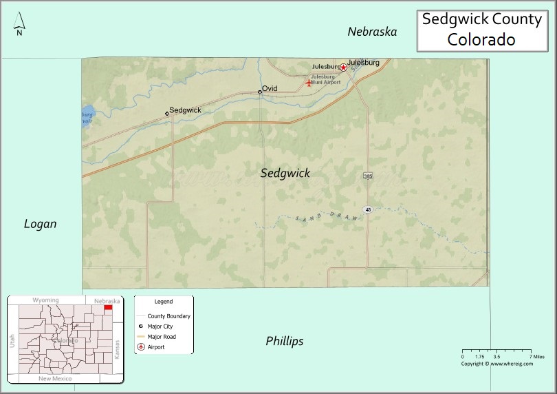
About Sedgwick County Map, Colorado: The map showing the county boundary, county seat, major cities, highways, water bodies and neighbouring counties.
Most Viewed Links
Map of Sedgwick County, Colorado
Sedgwick County is a county located in the U.S. state of Colorado. It's county seat is Julesburg. As per 2020 census, the population of Sedgwick County is 2336 people and population density is square miles. According to the United States Census Bureau, the county has a total area of 548.83 sq mi (1,421 km2). Sedgwick County was established on -3917.
Sedgwick County Facts
| Continent | North America |
| Country | United States |
| State | Colorado |
| County Seat | Julesburg |
| Largest City/Town | Julesburg |
| Established | 1889 |
| Total Area | 549 sq mi (1,422 sq km) |
| Land Area | 548 sq mi (1,419 sq km) |
| Water Area | 1 sq mi (3 sq km) |
| Population | 2,336 (Census 2020) |
| Population Density | 4.3 people per sq mi |
| Time Zone | Mountain Time Zone (MST/MDT) |
| Major Highways | Interstate 76, US Highway 138, State Highway 113 |
| Major Rivers | South Platte River |
| Neighboring Counties | Logan County, Phillips County, Deuel County (NE), Perkins County (NE), Cheyenne County (NE) |
| Famous For | South Platte River valley, Julesburg history, agriculture, and High Plains landscapes |
| Top Attractions | Fort Sedgwick Museum, Julesburg historical sites, South Platte River recreation, Pony Express history |
| Official Website | Official Website |
About Sedgwick County, Colorado
Sedgwick County is located in northeastern Colorado in the United States and was established in 1889. The county seat and largest town is Julesburg. The county is known for agriculture, frontier history, transportation heritage, and scenic High Plains landscapes along the South Platte River.
Cities and Towns in Sedgwick County, Colorado
| City/Town | Population (Census 2020) | Latitude & Longitude |
|---|---|---|
| Julesburg (county seat) | 1,307 | 40.9883°N, 102.2630°W |
| Ovid | 271 | 40.9608°N, 102.3897°W |
| Sedgwick | 152 | 40.9361°N, 102.5258°W |
| Iliff | 267 | 40.7600°N, 103.0458°W |
| Brownson | Historic area | 40.9567°N, 102.3061°W |
| Jumbo Reservoir region | Recreation area | 40.7350°N, 102.1933°W |
| South Platte Valley | Agricultural landscape region | 40.9500°N, 102.3500°W |
| High Plains prairie region | Rural landscape area | 40.9000°N, 102.4000°W |
Golf Courses in Sedgwick County, Colorado
| Golf Course | Location | Latitude & Longitude |
|---|---|---|
| Julesburg Golf Club | Julesburg | 40.9872°N, 102.2619°W |
| Riverview Golf Club | Sterling nearby | 40.6297°N, 103.2153°W |
| Indianhead Golf Course | Kimball nearby, Nebraska | 41.2386°N, 103.6647°W |
Roads and Highways in Sedgwick County, Colorado
Major highways connect the county to Nebraska, northeastern Colorado, and regional transportation routes.
- Interstate 76 - major interstate connecting Julesburg with Denver and Nebraska
- US Highway 138 - regional east-west route following the South Platte River valley
- Colorado State Highway 113 - highway linking Julesburg with nearby Nebraska communities
Neighboring Counties of Sedgwick County
- Logan County (west)
- Phillips County (southwest)
- Deuel County, Nebraska (north)
- Perkins County, Nebraska (northwest)
- Cheyenne County, Nebraska (east)
Top Attractions in Sedgwick County, Colorado
The county offers a mix of frontier history, prairie scenery, and outdoor recreation attractions.
- Fort Sedgwick Museum - local history museum focused on frontier settlement and military history
- Julesburg historical sites - landmarks tied to Pony Express, Overland Trail, and railroad history
- South Platte River recreation areas - fishing, birdwatching, and outdoor activities
- Jumbo Reservoir State Wildlife Area nearby - boating, fishing, camping, and wildlife viewing
- Pony Express Trail heritage locations - historic transportation route attractions
- Historic railroad sites in Julesburg - exhibits connected to western railroad expansion
- High Plains prairie scenic drives - open landscapes and rural Colorado scenery
- Local agricultural fairs and rodeos - celebrations of ranching and farming traditions
- Wildlife habitat areas - opportunities for migratory birdwatching and prairie wildlife viewing
- South Platte Valley farming landscapes - irrigated agricultural scenery and historic homesteads
- Historic Overland Trail regions - pioneer travel and frontier-era heritage attractions
- Small-town community events and festivals - local cultural and historical gatherings
Distance from Sedgwick County to Nearby Cities
The following distances are measured by road (driving).
- Julesburg to Sterling (Logan County), Colorado - 50 mi (80 km)
- Julesburg to Holyoke (Phillips County), Colorado - 54 mi (87 km)
- Julesburg to North Platte (Lincoln County), Nebraska - 95 mi (153 km)
- Julesburg to Fort Collins (Larimer County), Colorado - 143 mi (230 km)
- Julesburg to Denver (Denver County), Colorado - 188 mi (303 km)
- Julesburg to Cheyenne (Laramie County), Wyoming - 123 mi (198 km)
- Julesburg to Omaha (Douglas County), Nebraska - 329 mi (529 km)
- Julesburg to Wichita (Sedgwick County), Kansas - 395 mi (636 km)
- Julesburg to Colorado Springs (El Paso County), Colorado - 260 mi (418 km)
- Julesburg to Grand Junction (Mesa County), Colorado - 398 mi (641 km)
- Julesburg to Amarillo (Potter County), Texas - 444 mi (715 km)
- Julesburg to Salt Lake City (Salt Lake County), Utah - 495 mi (797 km)
FAQs about Sedgwick County
Sedgwick County is located in northeastern Colorado near the Nebraska border in the United States.
The population of Sedgwick County was 2,336 according to the Census 2020.
Sedgwick County is known for frontier history, agriculture, South Platte River landscapes, and Pony Express heritage.
The county is served by Interstate 76, US Highway 138, and Colorado State Highway 113.
Popular attractions include the Fort Sedgwick Museum, South Platte River recreation areas, Jumbo Reservoir nearby, and Julesburg historic sites.
References
- QuickFacts - U.S. Census Bureau
- United States Census Bureau
- United States Geological Survey (USGS)
- National Geodetic Survey
- Official Website
- Adams County Map
- Alamosa County Map
- Arapahoe County Map
- Archuleta County Map
- Baca County Map
- Bent County Map
- Boulder County Map
- Broomfield County Map
- Chaffee County Map
- Cheyenne County Map
- Clear Creek County Map
- Conejos County Map
- Costilla County Map
- Crowley County Map
- Custer County Map
- Delta County Map
- Denver County Map
- Dolores County Map
- Douglas County Map
- Eagle County Map
- Elbert County Map
- El Paso County Map
- Fremont County Map
- Garfield County Map
- Gilpin County Map
- Grand County Map
- Gunnison County Map
- Hinsdale County Map
- Huerfano County Map
- Jackson County Map
- Jefferson County Map
- Kiowa County Map
- Kit Carson County Map
- Lake County Map
- La Plata County Map
- Larimer County Map
- Las Animas County Map
- Lincoln County Map
- Logan County Map
- Mesa County Map
- Mineral County Map
- Moffat County Map
- Montezuma County Map
- Montrose County Map
- Morgan County Map
- Otero County Map
- Ouray County Map
- Park County Map
- Phillips County Map
- Pitkin County Map
- Prowers County Map
- Pueblo County Map
- Rio Blanco County Map
- Rio Grande County Map
- Routt County Map
- Saguache County Map
- San Juan County Map
- San Miguel County Map
- Sedgwick County Map
- Summit County Map
- Teller County Map
- Washington County Map
- Weld County Map
- Yuma County Map
- Alabama Counties
- Alaska boroughs
- Arizona Counties
- Arkansas Counties
- California County Map
- Colorado Counties
- Connecticut Counties
- Delaware Counties
- Florida County Map
- Georgia County Map
- Hawaii Counties
- Idaho Counties
- Illinois Counties
- Indiana Counties
- Iowa Counties
- Kansas Counties
- Kentucky Counties
- Louisiana Counties
- Maine Counties
- Maryland Counties
- Massachusetts Counties
- Michigan County Map
- Minnesota Counties
- Mississippi Counties
- Missouri Counties
- Montana Counties
- Nebraska Counties
- Nevada Counties
- New York Counties
- New Hampshire Counties
- New Jersey Counties
- New Mexico Counties
- North Carolina Counties
- North Dakota Counties
- Ohio County Map
- Oklahoma Counties
- Oregon Counties
- Pennsylvania Counties
- Rhode Island Counties
- South Carolina Counties
- South Dakota Counties
- Map of Tennessee
- Texas County Map
- Utah Counties
- Vermont Counties
- Virginia Counties
- Washington Counties
- West Virginia Counties
- Wisconsin Counties
- Wyoming Counties