Map of Gilpin County - Gilpin County is a county located in the U.S. state of Colorado. Gilpin County Map showing cities, highways, important places and water bodies. Get Where is Gilpin County located in the map, major cities in Gilpin county, population, areas, and places of interest.
Map of Gilpin County, Colorado
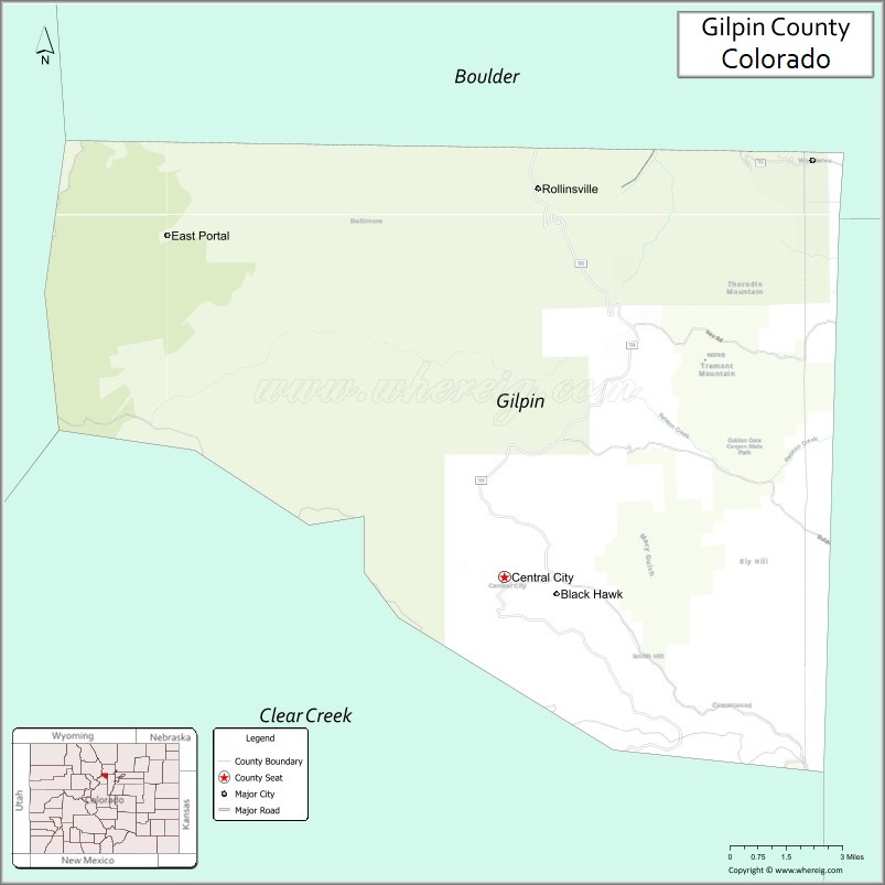
About Gilpin County Map, Colorado: The map showing the county boundary, county seat, major cities, highways, water bodies and neighbouring counties.
Most Viewed Links
Map of Gilpin County, Colorado
Gilpin County is a county located in the U.S. state of Colorado. It's county seat is Central City. As per 2020 census, the population of Gilpin County is 5873 people and population density is square miles. According to the United States Census Bureau, the county has a total area of 150.15 sq mi (389 km2). Gilpin County was established on -13938.
Gilpin County Facts
| Continent | North America |
| Country | United States |
| State | Colorado |
| County Seat | Central City |
| Largest City/Town | Black Hawk |
| Established | 1861 |
| Total Area | 150 sq mi (389 sq km) |
| Land Area | 150 sq mi (389 sq km) |
| Water Area | 0.2 sq mi (0.5 sq km) |
| Population | 5,867 (Census 2020) |
| Population Density | 39.1 people per sq mi |
| Time Zone | Mountain Time Zone (MST/MDT) |
| Major Highways | State Highway 119, State Highway 46 |
| Major Rivers | Clear Creek watershed |
| Neighboring Counties | Boulder County, Clear Creek County, Jefferson County |
| Famous For | Historic mining towns, casinos, Gold Rush history, and mountain scenery |
| Top Attractions | Black Hawk casinos, Central City Opera House, Golden Gate Canyon nearby, scenic mountain drives |
| Official Website | Official Website |
About Gilpin County, Colorado
Gilpin County is located in north-central Colorado in the United States and was established in 1861 as one of the original counties of the Colorado Territory. The county seat is Central City, while Black Hawk is the largest city. The county is known for Colorado Gold Rush history, mountain casinos, historic mining communities, scenic drives, and alpine recreation.
Cities and Towns in Gilpin County, Colorado
| City/Town | Population (Census 2020) | Latitude & Longitude |
|---|---|---|
| Central City (county seat) | 779 | 39.8019°N, 105.5142°W |
| Black Hawk | 127 | 39.8011°N, 105.4931°W |
| Rollinsville (CDP) | 194 | 39.9175°N, 105.5011°W |
| Tolland (CDP) | 50 | 39.9075°N, 105.5908°W |
| Mid Gilpin (CDP) | 1,900 | 39.8700°N, 105.4800°W |
| Russell Gulch (historic community) | Historic site | 39.7889°N, 105.5042°W |
Golf Courses in Gilpin County, Colorado
| Golf Course | Location | Latitude & Longitude |
|---|---|---|
| Coal Creek Golf Course | Louisville nearby | 39.9592°N, 105.1386°W |
| Indian Peaks Golf Course | Lafayette nearby | 39.9919°N, 105.1158°W |
| Evergreen Golf Course | Evergreen nearby | 39.6436°N, 105.3214°W |
Roads and Highways in Gilpin County, Colorado
Major highways connect the county to Denver, mountain recreation areas, and historic mining communities.
- Colorado State Highway 119 - scenic mountain highway connecting Black Hawk and Central City with Boulder and Interstate 70
- Colorado State Highway 46 - route linking Central City with Golden Gate Canyon and Jefferson County
Neighboring Counties of Gilpin County
- Boulder County (north)
- Jefferson County (south and east)
- Clear Creek County (southwest)
Top Attractions in Gilpin County, Colorado
The county offers a mix of historical and recreational attractions.
- Black Hawk Casinos - major gaming and entertainment destination in the Rocky Mountains
- Central City Opera House - historic opera venue known for summer performances and Gold Rush history
- Golden Gate Canyon State Park nearby - mountain park with hiking, camping, and scenic overlooks
- Central City Historic District - preserved mining-era buildings, museums, and heritage attractions
- Gilpin History Museum - exhibits covering mining, railroads, and pioneer life
- Apex Valley and Virginia Canyon Road - scenic drives through historic mining landscapes
- Rollins Pass Area - mountain recreation destination with hiking and railroad history
- Moffat Tunnel West Portal nearby - historic railroad engineering landmark
- Russell Gulch Ghost Town Area - historic Gold Rush settlement remnants
- St. Mary's Glacier nearby - alpine hiking area with mountain lake scenery
- Clear Creek Recreation Areas - fishing, hiking, and scenic mountain access points
- Century Casino and Ameristar Resort - entertainment complexes in Black Hawk
Distance from Gilpin County to Nearby Cities
The following distances are measured by road (driving).
- Central City to Denver (Denver County), Colorado - 38 mi (61 km)
- Central City to Boulder (Boulder County), Colorado - 31 mi (50 km)
- Central City to Golden (Jefferson County), Colorado - 29 mi (47 km)
- Central City to Idaho Springs (Clear Creek County), Colorado - 15 mi (24 km)
- Central City to Estes Park (Larimer County), Colorado - 58 mi (93 km)
- Central City to Fort Collins (Larimer County), Colorado - 73 mi (117 km)
- Central City to Breckenridge (Summit County), Colorado - 71 mi (114 km)
- Central City to Colorado Springs (El Paso County), Colorado - 108 mi (174 km)
- Central City to Vail (Eagle County), Colorado - 93 mi (150 km)
- Central City to Grand Junction (Mesa County), Colorado - 250 mi (402 km)
- Central City to Winter Park (Grand County), Colorado - 42 mi (68 km)
- Central City to Georgetown (Clear Creek County), Colorado - 28 mi (45 km)
FAQs about Gilpin County
Gilpin County is located in north-central Colorado within the Rocky Mountains west of Denver in the United States.
The population of Gilpin County was 5,867 according to the Census 2020.
Gilpin County is known for Gold Rush history, mountain casinos, historic mining towns, and scenic mountain landscapes.
The county is served by Colorado State Highway 119 and Colorado State Highway 46.
Yes, Gilpin County is home to Black Hawk and Central City casinos, which are among Colorado's major gaming destinations.
References
- QuickFacts - U.S. Census Bureau
- United States Census Bureau
- United States Geological Survey (USGS)
- National Geodetic Survey
- Official Website
- Adams County Map
- Alamosa County Map
- Arapahoe County Map
- Archuleta County Map
- Baca County Map
- Bent County Map
- Boulder County Map
- Broomfield County Map
- Chaffee County Map
- Cheyenne County Map
- Clear Creek County Map
- Conejos County Map
- Costilla County Map
- Crowley County Map
- Custer County Map
- Delta County Map
- Denver County Map
- Dolores County Map
- Douglas County Map
- Eagle County Map
- Elbert County Map
- El Paso County Map
- Fremont County Map
- Garfield County Map
- Gilpin County Map
- Grand County Map
- Gunnison County Map
- Hinsdale County Map
- Huerfano County Map
- Jackson County Map
- Jefferson County Map
- Kiowa County Map
- Kit Carson County Map
- Lake County Map
- La Plata County Map
- Larimer County Map
- Las Animas County Map
- Lincoln County Map
- Logan County Map
- Mesa County Map
- Mineral County Map
- Moffat County Map
- Montezuma County Map
- Montrose County Map
- Morgan County Map
- Otero County Map
- Ouray County Map
- Park County Map
- Phillips County Map
- Pitkin County Map
- Prowers County Map
- Pueblo County Map
- Rio Blanco County Map
- Rio Grande County Map
- Routt County Map
- Saguache County Map
- San Juan County Map
- San Miguel County Map
- Sedgwick County Map
- Summit County Map
- Teller County Map
- Washington County Map
- Weld County Map
- Yuma County Map
- Alabama Counties
- Alaska boroughs
- Arizona Counties
- Arkansas Counties
- California County Map
- Colorado Counties
- Connecticut Counties
- Delaware Counties
- Florida County Map
- Georgia County Map
- Hawaii Counties
- Idaho Counties
- Illinois Counties
- Indiana Counties
- Iowa Counties
- Kansas Counties
- Kentucky Counties
- Louisiana Counties
- Maine Counties
- Maryland Counties
- Massachusetts Counties
- Michigan County Map
- Minnesota Counties
- Mississippi Counties
- Missouri Counties
- Montana Counties
- Nebraska Counties
- Nevada Counties
- New York Counties
- New Hampshire Counties
- New Jersey Counties
- New Mexico Counties
- North Carolina Counties
- North Dakota Counties
- Ohio County Map
- Oklahoma Counties
- Oregon Counties
- Pennsylvania Counties
- Rhode Island Counties
- South Carolina Counties
- South Dakota Counties
- Map of Tennessee
- Texas County Map
- Utah Counties
- Vermont Counties
- Virginia Counties
- Washington Counties
- West Virginia Counties
- Wisconsin Counties
- Wyoming Counties