Map of Hinsdale County - Hinsdale County is a county located in the U.S. state of Colorado. Hinsdale County Map showing cities, highways, important places and water bodies. Get Where is Hinsdale County located in the map, major cities in Hinsdale county, population, areas, and places of interest.
Map of Hinsdale County, Colorado
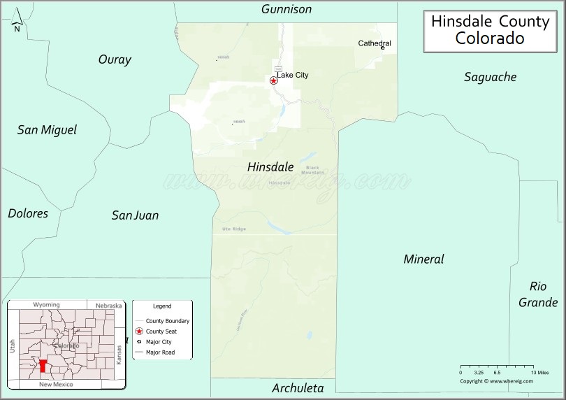
About Hinsdale County Map, Colorado: The map showing the county boundary, county seat, major cities, highways, water bodies and neighbouring counties.
Most Viewed Links
Map of Hinsdale County, Colorado
Hinsdale County is a county located in the U.S. state of Colorado. It's county seat is Lake City. As per 2020 census, the population of Hinsdale County is 781 people and population density is square miles. According to the United States Census Bureau, the county has a total area of 1,123.35 sq mi (2,909 km2). Hinsdale County was established on -9454.
Hinsdale County Facts
| Continent | North America |
| Country | United States |
| State | Colorado |
| County Seat | Lake City |
| Largest City/Town | Lake City |
| Established | 1874 |
| Total Area | 1,123 sq mi (2,909 sq km) |
| Land Area | 1,117 sq mi (2,893 sq km) |
| Water Area | 6 sq mi (16 sq km) |
| Population | 788 (Census 2020) |
| Population Density | 0.7 people per sq mi |
| Time Zone | Mountain Time Zone (MST/MDT) |
| Major Highways | State Highway 149 |
| Major Rivers | Lake Fork Gunnison River, Gunnison River watershed |
| Neighboring Counties | Saguache County, Mineral County, Archuleta County, San Juan County, Ouray County, Gunnison County |
| Famous For | San Juan Mountains, alpine wilderness, Lake City, and scenic mountain passes |
| Top Attractions | Alpine Loop Scenic Byway, Lake San Cristobal, Uncompahgre Peak, San Juan National Forest |
| Official Website | Official Website |
About Hinsdale County, Colorado
Hinsdale County is located in southwestern Colorado in the United States and was established in 1874. The county seat and largest community is Lake City. The county is known for rugged mountain scenery, alpine lakes, historic mining towns, wilderness recreation, and remote landscapes in the San Juan Mountains.
Cities and Communities in Hinsdale County, Colorado
| City/Town | Population (Census 2020) | Latitude & Longitude |
|---|---|---|
| Lake City (county seat) | 432 | 38.0297°N, 107.3150°W |
| Capitol City (historic site) | Historic ghost town | 37.9944°N, 107.2556°W |
| Cathedral (historic site) | Historic mining area | 37.9853°N, 107.2639°W |
| Lake San Cristobal communities | Regional area | 37.9858°N, 107.2611°W |
| Slumgullion Pass area | Mountain region | 37.9892°N, 107.1903°W |
Golf Courses in Hinsdale County, Colorado
| Golf Course | Location | Latitude & Longitude |
|---|---|---|
| Lake City Community Golf Area | Lake City | 38.0306°N, 107.3161°W |
| Rio Grande Club & Resort | South Fork nearby | 37.6658°N, 106.6486°W |
| Cobble Creek Golf Community | Montrose nearby | 38.4650°N, 107.8475°W |
Roads and Highways in Hinsdale County, Colorado
Mountain highways and scenic byways provide access to alpine recreation areas and historic mining regions.
- Colorado State Highway 149 - scenic highway connecting Lake City with Gunnison and South Fork
- Alpine Loop Scenic Byway - historic mountain route connecting Lake City with Silverton and Ouray via high mountain passes
Neighboring Counties of Hinsdale County
- Gunnison County (north)
- Saguache County (east)
- Mineral County (southeast)
- Archuleta County (south)
- San Juan County (west)
- Ouray County (northwest)
Top Attractions in Hinsdale County, Colorado
The county offers a mix of natural and historical attractions.
- Lake San Cristobal - large natural alpine lake popular for boating, fishing, and camping
- Alpine Loop Scenic Byway - famous high-elevation jeep trail through historic mining areas
- Uncompahgre Peak - one of Colorado's highest mountains and a major hiking destination
- San Juan National Forest - forest recreation area with hiking, camping, and wildlife viewing
- Weminuche Wilderness access areas - remote wilderness known for backpacking and alpine scenery
- Slumgullion Pass - scenic mountain pass featuring dramatic geological formations
- Lake City Historic District - preserved mining-era buildings and museums
- Engineer Pass and Cinnamon Pass - scenic four-wheel-drive mountain routes
- American Basin Wildflower Area - famous alpine wildflower viewing destination
- Gunnison National Forest access points - recreation areas for hiking and fishing
- Capitol City Ghost Town - historic abandoned mining settlement
- Henson Creek Valley - scenic valley known for waterfalls, trails, and mountain views
Distance from Hinsdale County to Nearby Cities
The following distances are measured by road (driving).
- Lake City to Gunnison (Gunnison County), Colorado - 55 mi (89 km)
- Lake City to Montrose (Montrose County), Colorado - 94 mi (151 km)
- Lake City to Durango (La Plata County), Colorado - 125 mi (201 km)
- Lake City to Salida (Chaffee County), Colorado - 126 mi (203 km)
- Lake City to Ouray (Ouray County), Colorado - 84 mi (135 km)
- Lake City to Creede (Mineral County), Colorado - 56 mi (90 km)
- Lake City to Grand Junction (Mesa County), Colorado - 168 mi (270 km)
- Lake City to Colorado Springs (El Paso County), Colorado - 225 mi (362 km)
- Lake City to Denver (Denver County), Colorado - 247 mi (398 km)
- Lake City to Telluride (San Miguel County), Colorado - 119 mi (191 km)
- Lake City to Alamosa (Alamosa County), Colorado - 122 mi (196 km)
- Lake City to Moab (Grand County), Utah - 258 mi (415 km)
FAQs about Hinsdale County
Hinsdale County is located in southwestern Colorado within the San Juan Mountains region of the United States.
The population of Hinsdale County was 788 according to the Census 2020.
Hinsdale County is known for alpine wilderness, mountain passes, Lake City, and scenic San Juan Mountain landscapes.
The county is primarily served by Colorado State Highway 149 and the Alpine Loop Scenic Byway.
Popular attractions include Lake San Cristobal, the Alpine Loop Scenic Byway, Uncompahgre Peak, and the San Juan National Forest.
References
- QuickFacts - U.S. Census Bureau
- United States Census Bureau
- United States Geological Survey (USGS)
- National Geodetic Survey
- Official Website
- Adams County Map
- Alamosa County Map
- Arapahoe County Map
- Archuleta County Map
- Baca County Map
- Bent County Map
- Boulder County Map
- Broomfield County Map
- Chaffee County Map
- Cheyenne County Map
- Clear Creek County Map
- Conejos County Map
- Costilla County Map
- Crowley County Map
- Custer County Map
- Delta County Map
- Denver County Map
- Dolores County Map
- Douglas County Map
- Eagle County Map
- Elbert County Map
- El Paso County Map
- Fremont County Map
- Garfield County Map
- Gilpin County Map
- Grand County Map
- Gunnison County Map
- Hinsdale County Map
- Huerfano County Map
- Jackson County Map
- Jefferson County Map
- Kiowa County Map
- Kit Carson County Map
- Lake County Map
- La Plata County Map
- Larimer County Map
- Las Animas County Map
- Lincoln County Map
- Logan County Map
- Mesa County Map
- Mineral County Map
- Moffat County Map
- Montezuma County Map
- Montrose County Map
- Morgan County Map
- Otero County Map
- Ouray County Map
- Park County Map
- Phillips County Map
- Pitkin County Map
- Prowers County Map
- Pueblo County Map
- Rio Blanco County Map
- Rio Grande County Map
- Routt County Map
- Saguache County Map
- San Juan County Map
- San Miguel County Map
- Sedgwick County Map
- Summit County Map
- Teller County Map
- Washington County Map
- Weld County Map
- Yuma County Map
- Alabama Counties
- Alaska boroughs
- Arizona Counties
- Arkansas Counties
- California County Map
- Colorado Counties
- Connecticut Counties
- Delaware Counties
- Florida County Map
- Georgia County Map
- Hawaii Counties
- Idaho Counties
- Illinois Counties
- Indiana Counties
- Iowa Counties
- Kansas Counties
- Kentucky Counties
- Louisiana Counties
- Maine Counties
- Maryland Counties
- Massachusetts Counties
- Michigan County Map
- Minnesota Counties
- Mississippi Counties
- Missouri Counties
- Montana Counties
- Nebraska Counties
- Nevada Counties
- New York Counties
- New Hampshire Counties
- New Jersey Counties
- New Mexico Counties
- North Carolina Counties
- North Dakota Counties
- Ohio County Map
- Oklahoma Counties
- Oregon Counties
- Pennsylvania Counties
- Rhode Island Counties
- South Carolina Counties
- South Dakota Counties
- Map of Tennessee
- Texas County Map
- Utah Counties
- Vermont Counties
- Virginia Counties
- Washington Counties
- West Virginia Counties
- Wisconsin Counties
- Wyoming Counties