
Where is Fort Carson Located? - Fort Carson is a city located in the El Paso County of Colorado, United States. Fort Carson lies between 39.1582 Degrees North latitudes and 75.5244 Degrees West longitudes.
Location Map of Fort Carson, Colorado
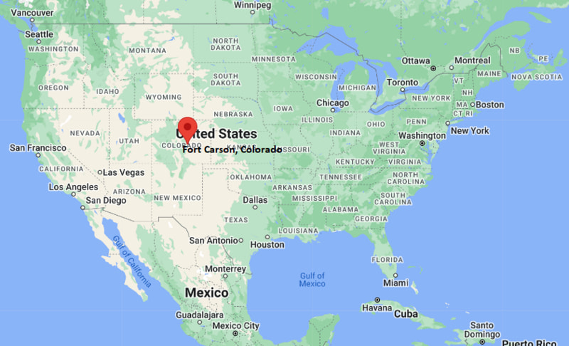
Fort Carson Map, Colorado, USA
Where is Fort Carson?: The Google Map showing the location of Fort Carson in the U.S. state of Colorado.
Where is Fort Carson Located?
Fort Carson is a city located in the El Paso County of Colorado, United States. Fort Carson lies between 39.1582 Degrees North latitudes and 75.5244 Degrees West longitudes. According to 2020 U.S.census, the population of Fort Carson city is 17693 people and the city has a total area of 8.59 sq mi. The city has numerous parks and recreational facilities.
Most Viewed US Maps
| USA Sttae Map | USA Region Map | USA Road Map |
| USA County Map | Where is USA in World Map? | US ZIP Code Map |
| USA Time Zones Map | US State and Capitals Map | USA Physical Map |
Find 4,400+ U.S. Cities by State - Explore Their Locations and Get Detailed Information
Fort Carson, Colorado Quick Facts
| Property | Information |
|---|---|
| Place | Fort Carson (Census-designated place) |
| County | El Paso County |
| State | Colorado |
| State Capital | Denver |
| US Region | Western United States |
| Latitude | 38.7416° N |
| Longitude | 104.7886° W |
| Elevation | 5,840 ft (1,780 m) |
| Land Area | 9.45 sq mi |
| Water Area | 0.03 sq mi |
| Total Area | 9.48 sq mi |
| Population (latest Census year) | 17,693 (2020 Census) |
| Population Density | 1,872 per sq mi |
| ZIP Code | 80913 |
| Area Code | 719 |
| Time Zone Standard | Mountain Standard Time (MST, UTC−7) |
| Time Zone Daylight | Mountain Daylight Time (MDT, UTC−6) |
| Currency | US Dollar (USD) |
| FIPS Code | 08-27450 |
| Congressional District | 5th Congressional District |
Nearby Cities to Fort Carson, Colorado
- Security-Widefield, Colorado — 3 mi East
- Fountain, Colorado — 5 mi South
- Colorado Springs, Colorado — 7 mi North
- Cimarron Hills, Colorado — 11 mi Northeast
- Manitou Springs, Colorado — 12 mi Northwest
- Fort Collins, Colorado — 78 mi North
- Woodland Park, Colorado — 25 mi Northwest
- Pueblo, Colorado — 42 mi South
- Castle Rock, Colorado — 52 mi North
- Denver, Colorado — 72 mi North
Driving Distances from Fort Carson, Colorado
| City | State | Distance (mi) | Approx. Drive Time |
|---|---|---|---|
| Security-Widefield | Colorado | 3 | 8 min |
| Fountain | Colorado | 5 | 10 min |
| Colorado Springs | Colorado | 7 | 15 min |
| Cimarron Hills | Colorado | 11 | 20 min |
| Manitou Springs | Colorado | 12 | 22 min |
| Woodland Park | Colorado | 25 | 35 min |
| Pueblo | Colorado | 42 | 45 min |
| Castle Rock | Colorado | 52 | 55 min |
| Denver | Colorado | 72 | 1 hr 15 min |
| Fort Collins | Colorado | 78 | 1 hr 30 min |
Transportation and Connectivity in Fort Carson, Colorado
| Category | Information |
|---|---|
| Airport Name | Colorado Springs Airport |
| IATA Code | COS |
| Port | Not applicable |
| Major Highways | Interstate 25, Colorado State Highway 115, U.S. Route 85/87 |
| Train/Amtrak Service | Nearest Amtrak service is at Denver (via connecting bus) |
| Local Bus/Transit Service | Mountain Metropolitan Transit and Fort Carson military shuttle services |
- Interstate 25 provides direct access to Colorado Springs, Pueblo, Denver, and northern Colorado.
- Colorado State Highway 115 serves as the primary route connecting Fort Carson with downtown Colorado Springs and nearby communities.
- U.S. Route 85/87 offers regional access across southern Colorado and connects with Interstate 25.
- Colorado Springs Airport, located nearby, provides convenient commercial air service for military personnel, residents, and visitors.
What are top Places to Visit in Fort Carson, Colorado
| Landmark Name | Type |
|---|---|
| Fort Carson Museum | Military Museum |
| Cheyenne Mountain State Park | State Park |
| Garden of the Gods | Natural Landmark |
| Cheyenne Mountain Zoo | Zoo |
| Pikes Peak | Mountain |
| National Museum of World War II Aviation | Museum |
| Bear Creek Regional Park | Regional Park |
| Seven Falls | Waterfall Attraction |
| Broadmoor Seven Falls | Scenic Attraction |
| United States Olympic & Paralympic Museum | Museum |
Colleges and Universities in Fort Carson, Colorado
| Institution Name | Type | Level | Notable For |
|---|---|---|---|
| Pikes Peak State College | Public | Community College | Transfer programs, workforce training and military education |
| University of Colorado Colorado Springs | Public | University | Engineering, business, nursing and research |
| Colorado State University Pueblo | Public | University | Business, engineering and health sciences |
| Department of Defense Education Activity (DoDEA) Schools | Public | K–12 District | Education for military-connected students at Fort Carson |
Waterbodies in Fort Carson, Colorado
Fountain Creek, Arkansas River, Quail Lake, Prospect Lake, Bear Creek, Monument Creek, Big Johnson Reservoir, Teller Reservoir
Golf Courses in Fort Carson, Colorado
Eisenhower Golf Club, Cheyenne Shadows Golf Club, Patty Jewett Golf Course, Valley Hi Golf Course, Pine Creek Golf Club, The Broadmoor Golf Club
Fort Carson, Colorado — Key Historical Facts
- Fort Carson was established in 1942 as Camp Carson during World War II to train U.S. Army personnel and was later renamed Fort Carson in honor of frontiersman Christopher "Kit" Carson.
- The installation became a permanent Army post after the war and expanded significantly during the Cold War, supporting numerous combat and support units.
- Fort Carson is home to the 4th Infantry Division and several other major Army commands that have participated in military operations around the world.
- Its strategic location near Colorado Springs provides access to extensive military training grounds, including the Piñon Canyon Maneuver Site in southeastern Colorado.
- Today, Fort Carson is one of the largest military installations in the western United States, serving as a major center for military training, family support, healthcare, and regional economic activity.
References
- U.S. Census Bureau
- Fort Carson U.S. Army Installation
- Pikes Peak State College
- El Paso County Government
Colorado Maps and Info
- Where is Arvada
- Where is Black Forest
- Where is Boulder
- Where is Brighton
- Where is Broomfield
- Where is Castle Rock
- Where is Centennial
- Where is Cimarron Hills
- Where is Clifton
- Where is Columbine
- Where is Commerce City
- Where is Dakota Ridge
- Where is Durango
- Where is Englewood
- Where is Erie
- Where is Evans
- Where is Firestone
- Where is Fort Carson
- Where is Fort Collins
- Where is Fountain
- Where is Frederick
- Where is Golden
- Where is Grand Junction
- Where is Greeley
- Where is Greenwood Village
- Where is Highlands Ranch
- Where is Johnstown
- Where is Ken Caryl
- Where is Lafayette
- Where is Lakewood
- Where is Littleton
- Where is Lone Tree
- Where is Longmont
- Where is Loveland
- Where is Montrose
- Where is Northglenn
- Where is Parker
- Where is Pueblo
- Where is Pueblo West
- Where is Security-Widefield
- Where is Sherrelwood
- Where is Thornton
- Where is Welby
- Where is Westminster
- Where is Wheat Ridge
- Where is Windsor