
Where is Littleton Located? - Littleton is a city located in the Arapahoe County seat County of Colorado, United States. Littleton lies between 41.3909 Degrees North latitudes and 72.8595 Degrees West longitudes.
Location Map of Littleton, Colorado
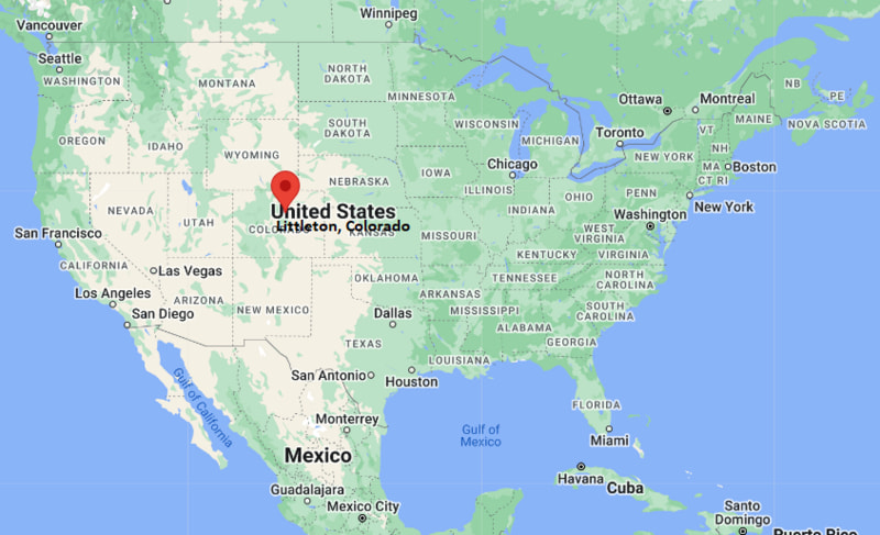
Littleton Map, Colorado, USA
Where is Littleton?: The Google Map showing the location of Littleton in the U.S. state of Colorado.
Where is Littleton Located?
Littleton is a city located in the Arapahoe County of Colorado, United States. Littleton lies between 41.3909 Degrees North latitudes and 72.8595 Degrees West longitudes. According to 2020 U.S.census, the population of Littleton city is 45652 people and the city has a total area of 12.63 sq mi. The city has numerous parks and recreational facilities.
Most Viewed US Maps
| USA Sttae Map | USA Region Map | USA Road Map |
| USA County Map | Where is USA in World Map? | US ZIP Code Map |
| USA Time Zones Map | US State and Capitals Map | USA Physical Map |
Find 4,400+ U.S. Cities by State - Explore Their Locations and Get Detailed Information
Littleton, Colorado Quick Facts
| Attribute | Details |
|---|---|
| City | Littleton |
| County | Arapahoe County |
| State | Colorado |
| State Capital | Denver |
| US Region | Western United States (Mountain Region) |
| Latitude | 39.6133° N |
| Longitude | 105.0166° W |
| Elevation | 5,351 ft (1,631 m) |
| Land Area | 13.79 sq mi |
| Water Area | 0.05 sq mi |
| Total Area | 13.84 sq mi |
| Population (2020 Census) | 45,652 |
| Population Density | 3,311 per sq mi |
| ZIP Code(s) | 80120, 80121, 80122, 80123, 80127, 80128 |
| Area Code(s) | 303, 720 |
| Time Zone Standard | Mountain Standard Time (MST, UTC−7) |
| Time Zone Daylight | Mountain Daylight Time (MDT, UTC−6) |
| Currency | United States Dollar (USD) |
| FIPS Code | 08-45255 |
| Congressional District | Colorado's 6th Congressional District |
Transportation and Connectivity in Littleton
| Category | Details |
|---|---|
| Airport Name | Denver International Airport |
| IATA Code | DEN |
| Secondary Airport | Centennial Airport |
| Major Highways | U.S. Route 85, C-470, Interstate 25, Santa Fe Drive |
| Train/Amtrak Service | RTD light rail service; Amtrak service in Denver |
| Local Bus/Transit Service | Regional Transportation District (RTD) |
- Littleton is part of the Denver metropolitan area and has strong regional transportation connections.
- RTD light rail provides direct transit connections between Littleton, Denver, and surrounding communities.
- Interstate 25 and C-470 provide access to Denver, the Front Range, and mountain destinations.
- Denver International Airport provides domestic and international air service approximately 45 miles northeast of the city.
Top Places to Visit in Littleton, Colorado
| Landmark Name | Type |
|---|---|
| Historic Downtown Littleton | Historic District |
| Chatfield State Park | State Park |
| Roxborough State Park (nearby) | Natural Area |
| Hudson Gardens | Botanical Garden |
| Littleton Museum | History Museum |
| South Platte Park and Carson Nature Center | Nature Preserve |
| Ketring Park | Community Park |
| Town Hall Arts Center | Performing Arts Venue |
| Reynolds Landing Park | Riverfront Park |
| Chatfield Reservoir | Reservoir Recreation Area |
Driving Distances from Littleton, Colorado to Nearby Cities
| City | State | Distance (mi) | Approx. Drive Time |
|---|---|---|---|
| Englewood | Colorado | 5 | 10 minutes |
| Lakewood | Colorado | 10 | 20 minutes |
| Denver | Colorado | 12 | 25 minutes |
| Centennial | Colorado | 8 | 15 minutes |
| Aurora | Colorado | 25 | 35 minutes |
| Boulder | Colorado | 40 | 55 minutes |
| Colorado Springs | Colorado | 75 | 1 hour 15 minutes |
| Fort Collins | Colorado | 75 | 1 hour 20 minutes |
| Pueblo | Colorado | 130 | 2 hours |
| Vail | Colorado | 120 | 2 hours |
Colleges and Universities in Littleton, Colorado
| Institution Name | Type | Level | Notable For |
|---|---|---|---|
| Arapahoe Community College | Public | Community College | Associate degrees, career training, business, technology, and healthcare programs |
| Colorado State University – Spur Campus (nearby) | Public | University | Research, agriculture, innovation, and applied sciences |
| University of Denver | Private | University | Law, business, international studies, research, and liberal arts |
| Metropolitan State University of Denver | Public | University | Business, aviation, education, healthcare, and professional programs |
| University of Colorado Denver | Public | University | Research, engineering, business, public affairs, and health sciences |
Waterbodies in Littleton, Colorado
Littleton is located along the South Platte River corridor in central Arapahoe County. Major nearby water resources include the South Platte River, Chatfield Reservoir, Chatfield Lake, and local streams. These waterways support recreation, wildlife habitat, flood management, and regional water supply systems.
Stadiums in Littleton
Littleton features several athletic facilities including Littleton Public Schools sports stadiums, Heritage High School Stadium, and nearby sports complexes. These venues host football, soccer, baseball, track and field, and community sporting events.
Littleton, Colorado — Key Historical Facts
- Littleton was founded during the Colorado Gold Rush era in the 1850s when settlers arrived in the South Platte River Valley.
- The community was named after Richard Sullivan Little, an engineer and early settler who helped develop local irrigation systems.
- Littleton was incorporated in 1890 and developed as an agricultural and transportation center near Denver.
- The arrival of railroads and growth of the Denver metropolitan area contributed to Littleton's suburban development during the twentieth century.
- Today, Littleton is known for its historic downtown, parks, trails, cultural attractions, and access to the Rocky Mountains.
References
- City of Littleton
- Arapahoe County Government
- U.S. Census Bureau
- Colorado Parks and Wildlife
- Visit Littleton
Colorado Maps and Info
- Where is Arvada
- Where is Black Forest
- Where is Boulder
- Where is Brighton
- Where is Broomfield
- Where is Castle Rock
- Where is Centennial
- Where is Cimarron Hills
- Where is Clifton
- Where is Columbine
- Where is Commerce City
- Where is Dakota Ridge
- Where is Durango
- Where is Englewood
- Where is Erie
- Where is Evans
- Where is Firestone
- Where is Fort Carson
- Where is Fort Collins
- Where is Fountain
- Where is Frederick
- Where is Golden
- Where is Grand Junction
- Where is Greeley
- Where is Greenwood Village
- Where is Highlands Ranch
- Where is Johnstown
- Where is Ken Caryl
- Where is Lafayette
- Where is Lakewood
- Where is Littleton
- Where is Lone Tree
- Where is Longmont
- Where is Loveland
- Where is Montrose
- Where is Northglenn
- Where is Parker
- Where is Pueblo
- Where is Pueblo West
- Where is Security-Widefield
- Where is Sherrelwood
- Where is Thornton
- Where is Welby
- Where is Westminster
- Where is Wheat Ridge
- Where is Windsor