
Kearney is a growing city in western Missouri, located in Clay County about 20 miles northeast of downtown Kansas City. It is known as the hometown of Jesse James and is surrounded by the rolling farmland and wooded landscapes of the Kansas City region. The city is also known for its historic sites, Jesse James Farm, and annual Jesse James Festival.
Location Map of Kearney, Clay County, Missouri
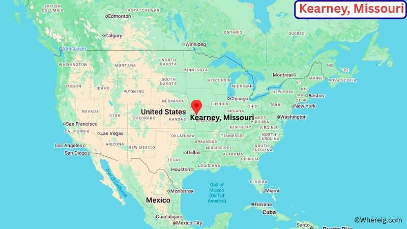
About Map: The map shows the location of Kearney in Clay County, in the U.S. state of Missouri.
Kearney Map, Missouri
About Kearney Map: The Google Map highlights the location of Kearney in Clay County, Missouri. Use the zoom, satellite, and street-view options to explore the city's neighborhoods, roads, and nearby places.
Where is Kearney Located?
Kearney is a city located in Clay County, Missouri, the United States. It lies in western Missouri, about 20 miles northeast of downtown Kansas City and roughly 15 miles north of Liberty. Kearney is part of the Kansas City metropolitan area and is surrounded by rolling farmland, wooded areas, and small streams. The city is located at approximately 39.367° North latitude and 94.362° West longitude. The 2020 Census recorded 10,404 residents. Kearney covers about 12.92 square miles, or 33.46 square kilometers. The community was incorporated in 1869 and was named after General Philip Kearny, a Union Army officer. Kearney is especially known for its connection to Jesse James, the famous 19th-century outlaw who was born and raised in the surrounding area. The Jesse James Farm and Museum preserves the historic site where James lived and died. The city's historic downtown and annual Jesse James Festival are also important parts of its local identity. A unique feature of Kearney is the combination of its rural roots and its growing connection to the Kansas City metropolitan area. Interstate 35 provides a major transportation corridor through the city, connecting Kearney with Kansas City, St. Joseph, and communities farther north. Nearby Watkins Woolen Mill State Historic Site also offers a look at Missouri's agricultural and industrial past.
Most Viewed US Maps
| USA Sttae Map | USA Region Map | USA Road Map |
| USA County Map | Where is USA in World Map? | US ZIP Code Map |
| USA Time Zones Map | US State and Capitals Map | USA Physical Map |
Find 4,400+ U.S. Cities by State - Explore Their Locations and Get Detailed Information
Kearney City Facts
| City | Kearney |
| State | Missouri |
| County | Clay County |
| Country | United States |
| Region | Western Missouri / Kansas City Metropolitan Area |
| Incorporated | 1869 |
| Founded | 1856 |
| Total Area | 12.92 sq mi (33.46 sq km) |
| Land Area | 12.84 sq mi (33.26 sq km) |
| Water Area | 0.08 sq mi (0.21 sq km) |
| Elevation | About 850 ft (259 m) |
| Population (2023 estimate) | About 11,000 |
| Population (2020 Census) | 10,404 |
| Population Density | About 810 people per sq mi |
| Time Zone | Central Time (CT) |
| ZIP Codes | 64060 |
| Area Code | 816, 975 |
| Major Highways | Interstate 35, Missouri Route 92, Missouri Route 33 |
| Public Transit | KCATA regional transit services |
| Major Attractions | Jesse James Farm and Museum, Watkins Woolen Mill State Historic Site, Kearney Historic Downtown, Jesse James Festival |
| Official Website | https://www.kearneymo.us/ |
Distance from Kearney, MO to Nearby Cities
- Liberty, MO – 10 miles (16 km)
- Excelsior Springs, MO – 12 miles (19 km)
- Smithville, MO – 10 miles (16 km)
- Gladstone, MO – 15 miles (24 km)
- North Kansas City, MO – 18 miles (29 km)
- Kansas City, MO – 20 miles (32 km)
- St. Joseph, MO – 40 miles (64 km)
- Independence, MO – 25 miles (40 km)
- Blue Springs, MO – 35 miles (56 km)
- Platte City, MO – 25 miles (40 km)
- Lawson, MO – 20 miles (32 km)
- Leavenworth, KS – 35 miles (56 km)
- Atchison, KS – 45 miles (72 km)
- Topeka, KS – 85 miles (137 km)
- Columbia, MO – 130 miles (209 km)
Top Attractions in Kearney
- Jesse James Farm and Museum – A historic site preserving the farm where the famous outlaw Jesse James was born and raised and where he was buried.
- Jesse James Festival – An annual community event celebrating Kearney's connection to Jesse James with parades, entertainment, exhibits, and family activities.
- Kearney Historic Downtown – A local commercial district featuring historic buildings, restaurants, shops, and community landmarks.
- Watkins Woolen Mill State Historic Site – A nearby historic site preserving a 19th-century woolen mill, farm, and Victorian home.
- Kearney City Park – A community recreation area with open spaces, sports facilities, walking paths, and family activities.
- Smithville Lake – A major recreational lake north of Kansas City offering boating, fishing, camping, hiking, and wildlife viewing.
- Liberty Historic District – A nearby historic area featuring the Clay County Courthouse, older homes, shops, and landmarks from Missouri's early history.
- Worlds of Fun – A major amusement park in Kansas City featuring roller coasters, family rides, and seasonal attractions.
Airports Near Kearney
- Charles B. Wheeler Downtown Airport (MKC) – 25 miles
- Kansas City International Airport (MCI) – 30 miles
- Rosecrans Memorial Airport (STJ) – 40 miles
- Lee's Summit Municipal Airport (LXT) – 45 miles
- New Century AirCenter (IXD) – 50 miles
Sources:
Population and area data sourced from the United States Census Bureau (2020 Census). General city information referenced from the official Kearney city website and local government records.
Other Missouri Maps & Info
- Where is Affton
- Where is Arnold
- Where is Ballwin
- Where is Belton
- Where is Blue Springs
- Where is Cape Girardeau
- Where is Chesterfield
- Where is Clayton
- Where is Columbia
- Where is Concord
- Where is Creve Coeur
- Where is Farmington
- Where is Ferguson
- Where is Florissant
- Where is Gladstone
- Where is Grandview
- Where is Hazelwood
- Where is Independence
- Where is Jefferson City
- Where is Joplin
- Where is Kirksville
- Where is Kirkwood
- Where is Lake St. Louis
- Where is Lee's Summit
- Where is Liberty
- Where is Manchester
- Where is Maryland Heights
- Where is Mehlville
- Where is Nixa
- Where is O'Fallon
- Where is Oakville
- Where is Old Jamestown
- Where is Ozark
- Where is Raymore
- Where is Raytown
- Where is Republic
- Where is Rolla
- Where is Sedalia
- Where is Spanish Lake
- Where is St. Charles
- Where is St. Joseph
- Where is St. Louis
- Where is St. Peters
- Where is University City
- Where is Warrensburg
- Where is Webster Groves
- Where is Wentzville
- Where is Wildwood